
A view of a vegetated inland coastline overlooking the water on Dauphin Island, Alabama. The island protects mainland Alabama’s coastal communities and resources from storms, while also providing recreational opportunities (fishing, beach tourism, etc.) and other economic benefits to the local community and state.
Images
St. Petersburg Coastal and Marine Science Center images.
Filter Total Items: 745

Dauphin Island, Alabama
A view of a vegetated inland coastline overlooking the water on Dauphin Island, Alabama. The island protects mainland Alabama’s coastal communities and resources from storms, while also providing recreational opportunities (fishing, beach tourism, etc.) and other economic benefits to the local community and state.
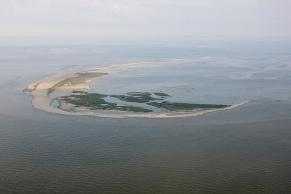
Aerial photograph looking southwest along Breton Island, Louisiana
Aerial photograph looking southwest along Breton Island, LouisianaAerial photograph looking southwest along Breton Island, Louisiana, taken July 2013
Aerial photograph looking southwest along Breton Island, Louisiana
Aerial photograph looking southwest along Breton Island, LouisianaAerial photograph looking southwest along Breton Island, Louisiana, taken July 2013

USGS researchers ride along the dune; Kennedy Space Center in distance
USGS researchers ride along the dune; Kennedy Space Center in distanceThe USGS collaborates with NASA, the University of Florida, National Park Service, and the U.S. Fish and Wildlife Service to assess coastal erosion hazards affecting space program infrastructure, habitat, and wildlife populations.

Point aux Chênes, Mississippi marsh push core
A short marsh push core, exhibiting a sandy event layer on top, collected from Point aux Chênes, Mississippi marsh during sample collection in October 2018 for sediment and radiochemical analyses.
A short marsh push core, exhibiting a sandy event layer on top, collected from Point aux Chênes, Mississippi marsh during sample collection in October 2018 for sediment and radiochemical analyses.

Point aux Chênes, Mississippi marsh shoreline
Looking south along the Point aux Chênes, Mississippi marsh shoreline during sample collection in October 2018; sediment probe located at the shoreline is used to assist in aligning sample collection along shore perpendicular transect.
Looking south along the Point aux Chênes, Mississippi marsh shoreline during sample collection in October 2018; sediment probe located at the shoreline is used to assist in aligning sample collection along shore perpendicular transect.

Coral cores like this one reveal geologic history of Keys reefs
Coral cores like this one reveal geologic history of Keys reefsUSGS Research Oceanographer Lauren Toth and Oceanographer Anastasios Stathakopoulos study a coral-reef core in the USGS’s Core Archive in St. Petersburg, Florida. Photo: Dominique Gallery, USGS.

Andrea "Andy" O'Neill in Monterey
“The ocean is the closest I can get to an unexplored world, without going into space... I mean, I feel a deep connection to the ocean and its constant rhythms, but when I visit, there's a new discovery or appreciation every time.
“The ocean is the closest I can get to an unexplored world, without going into space... I mean, I feel a deep connection to the ocean and its constant rhythms, but when I visit, there's a new discovery or appreciation every time.

Collection of a marsh sediment push core in Grand Bay in October 2018
Collection of a marsh sediment push core in Grand Bay in October 2018Two USGS scientists collect a marsh sediment push core in Grand Bay in October, 2018.
Collection of a marsh sediment push core in Grand Bay in October 2018
Collection of a marsh sediment push core in Grand Bay in October 2018Two USGS scientists collect a marsh sediment push core in Grand Bay in October, 2018.

Diadema antillarum, the long-spined sea urchin
Diadema antillarum, the long-spined sea urchin, is an ecologically important species in Caribbean coral reef habitats where it controls algal growth and coverage and helps keep reef surfaces clear for corals to grow and settle. In early 2022, the remaining D. antillarum populations began experiencing mass mortality in the Caribbean.
Diadema antillarum, the long-spined sea urchin, is an ecologically important species in Caribbean coral reef habitats where it controls algal growth and coverage and helps keep reef surfaces clear for corals to grow and settle. In early 2022, the remaining D. antillarum populations began experiencing mass mortality in the Caribbean.

Parrotfish grazing on coral in Buck Island Reef National Monument
Parrotfish grazing on coral in Buck Island Reef National MonumentParrotfish grazing on coral within an Acropora palmata framework in Buck Island Reef National Monument
Parrotfish grazing on coral in Buck Island Reef National Monument
Parrotfish grazing on coral in Buck Island Reef National MonumentParrotfish grazing on coral within an Acropora palmata framework in Buck Island Reef National Monument

Dead elkhorn coral at Buck Island Reef National Monument, St. Croix, U.S. Virgin Islands
Dead elkhorn coral at Buck Island Reef National Monument, St. Croix, U.S. Virgin IslandsPhoto shows a dead, relict reef framework built by the elkhorn coral, Acropora palmata in Buck Island Reef National Monument, St. Croix, U.S. Virgin Islands.

An egret walks in the surf of Dauphin Island beach
An egret walks in the surf of Dauphin Island beachAn egret walks in the shallow surf of an undeveloped beach on Dauphin Island, Alabama, with buildings viewed in the background from a different area on the island.
An egret walks in the surf of Dauphin Island beach
An egret walks in the surf of Dauphin Island beachAn egret walks in the shallow surf of an undeveloped beach on Dauphin Island, Alabama, with buildings viewed in the background from a different area on the island.

Erosion has taken a toll on this Keys coral
A reef in the Florida Keys National Marine Sanctuary with little living coral and extensive bioerosion. Photo taken under research permit number FKNMS-2016-085-A1. Credit: USGS, Ilsa Kuffner.
A reef in the Florida Keys National Marine Sanctuary with little living coral and extensive bioerosion. Photo taken under research permit number FKNMS-2016-085-A1. Credit: USGS, Ilsa Kuffner.
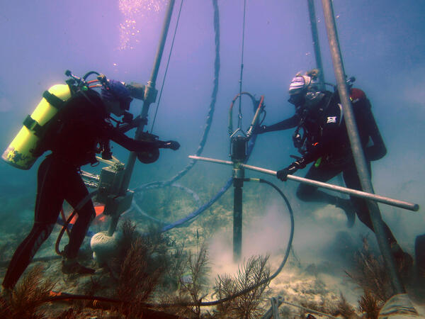
USGS scientists drill a coral-reef core in the Florida Keys
USGS scientists drill a coral-reef core in the Florida KeysResearch Oceanographer Lauren Toth and student volunteer Liz Whitcher drill a coral-reef core from a reef off Key West, Florida, in the Florida Keys National Marine Sanctuary. Photo taken under research permit FKNMS-2015-058. Credit: Anastasios Stathakopoulos, USGS.

Landsat 5 image of Tampa Bay Florida 1991
Landsat 5 captured this image of the Tampa Bay, Florida area on March 22, 1991.
Bands 7,2,1
Image processed at Center for Coastal Geology, St. Petersburg, Florida.
Landsat 5 captured this image of the Tampa Bay, Florida area on March 22, 1991.
Bands 7,2,1
Image processed at Center for Coastal Geology, St. Petersburg, Florida.

Sunrise at Jensen Beach, FL
A colorful sunrise appears over the horizon of a calm ocean offshore of Jensen Beach, Florida. USGS Scientist RC Mickey collects data for location and elevation of sea turtle crawls and associated beach profiles this stretch of coastline.
A colorful sunrise appears over the horizon of a calm ocean offshore of Jensen Beach, Florida. USGS Scientist RC Mickey collects data for location and elevation of sea turtle crawls and associated beach profiles this stretch of coastline.

Like many Keys corals, this one has no new growth
A modern coral reef in Dry Tortugas National Park. There is little living coral and high rates of bioerosion. Photo taken under research permit number DRTO-2018-SCI-0005. Credit: Lauren Toth, USGS
A modern coral reef in Dry Tortugas National Park. There is little living coral and high rates of bioerosion. Photo taken under research permit number DRTO-2018-SCI-0005. Credit: Lauren Toth, USGS

Relict Holocene coral-reef framework in the Dry Tortugas National Park
Relict Holocene coral-reef framework in the Dry Tortugas National ParkRelict Holocene coral-reef framework in the Florida Keys. Like many reefs in the western Atlantic, reefs here were just a few coral species: primary Acropora palmata and Orbicella spp. Recent disturbances have led to declines in the populations of those corals and relative increases in the abundance of more weedy taxa.

Relict Acropora palmata coral-reef framework in the Dry Tortugas
Relict Acropora palmata coral-reef framework in the Dry TortugasAcropora palmata coral-reef framework in the Dry Tortugas National Park, Florida Keys built more than 3000 years ago. That framework, which serves as the foundation for all of the critical ecosystem services reefs provide to society, is now rapidly eroding away.
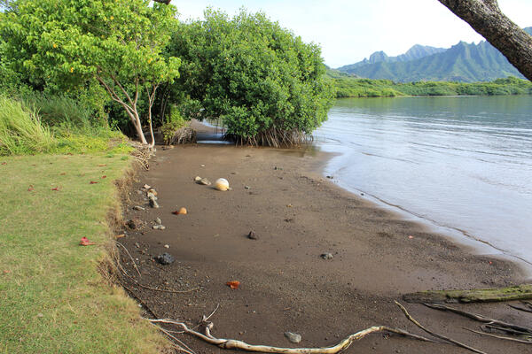
Waiāhole Beach Park near Mokoli'i, Oahu, Hawaii
Waiāhole Beach Park near Mokoli'i, Oahu, Hawaii, in an area without dunes. Photo by Michael Slattery, USGS.
Waiāhole Beach Park near Mokoli'i, Oahu, Hawaii, in an area without dunes. Photo by Michael Slattery, USGS.

Driftwood on the edge of a sandy beach on Fire Island
Driftwood on the edge of a sandy beach on Fire IslandDriftwood on the edge of a sandy beach, against the background of the Fire Island breach, with the other edge of the breach in the background.
Driftwood on the edge of a sandy beach on Fire Island
Driftwood on the edge of a sandy beach on Fire IslandDriftwood on the edge of a sandy beach, against the background of the Fire Island breach, with the other edge of the breach in the background.