
This Landsat 8 image from May 24th, 2017 shows an enthralling New Zealand landscape. Snow-capped mountain peaks, forests, farmland, and fog highlight the picturesque view of New Zealand's North Island. The scene was downloaded on March 9th, 2020 one of over 29,000 Landsat scenes downloaded worldwide that day. But this scene is special.
Landsat Satellite Missions
Bangladesh Coast of Bengal Bay
Landsat 9
Landsat 9
Canyonlands National Park
Landsat 8
Landsat 8
Center-Pivot Irrigation in Saudi Arabia
Landsat 7
Landsat 7
Southern Patagonia Icefield
Landsat 5
Landsat 5
Cape Town, False Bay, South Africa
Landsat 3
Landsat 3
In a September 21, 1966 press release, Secretary of the Department of the Interior, Stewart Udall announced the launching of "Project EROS" (Earth Resources Observation Satellites). Udall's vision was to observe the Earth for the benefit of all.
The Landsat Missions are comprised of Earth-observing operational satellites that carry remote sensors to collect data and image our planet as a part of the U.S. Geological Survey (USGS) National Land Imaging (NLI) Program. Products generated from the imagery acquired by the sensors carried on the Landsat satellites are hosted at the USGS Earth Resources Observation and Science (EROS) Center in Sioux Falls, South Dakota.
Media
Sources/Usage: Public Domain. View Media Details
Beginning in the 1960s, the remote sensing and science community worked to realize these missions for the benefit of humankind. Geography, geology, hydrology, and other natural resource management fields have all benefited from the holistic view of the Earth.
In a September 1966 press release, then Secretary of the Interior Stewart Udall, announced that the Department of the Interior (DOI) was launching "Project EROS (Earth Resources Observation Satellites)" to collect invaluable information about Earth through remote sensing satellite observation. Udall's vision was to observe the Earth for the benefit of all. Secretary Udall boldly revealed that National Aeronautics and Space Administration (NASA) and the DOI would collaborate on Earth-observing space technology to monitor the planet’s natural resources. He stated "the program will provide us with the opportunity to collect valuable resource data and use it to improve the quality of our environment."
The DOI, NASA, and the U.S. Department of Agriculture (USDA) then embarked on an ambitious effort to develop and launch the first civilian Earth observation satellite. These revolutionary satellites would be set in a heliosynchronous, near-polar orbit, completing several revolutions around the Earth every day to capture the land surface of the planet. The heliosynchronous, near-polar orbit means the satellite passes near the North and South pole consistently as it revolves around the Earth. This type of orbit allows a Landsat spacecraft to pass over the equator at a different longitude on each revolution, resulting in the spacecraft completing full coverage of the Earth after 251 orbits, about every 18 days.
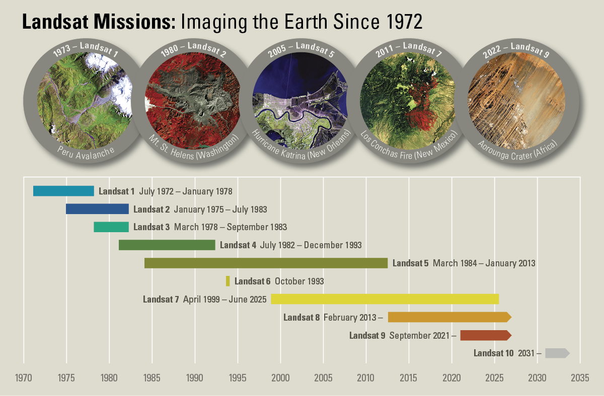
The interagency effort achieved their goal on July 23, 1972, with the launch of the Earth Resources Technology Satellite (ERTS-1), later renamed Landsat 1. Project EROS led to numerous international collaborations focusing on science and technology including a fundamental one on how to operate Landsat. Each commissioned satellite carried the storied heritage of the program. The launches of Landsat 2, Landsat 3, and Landsat 4 followed in 1975, 1978, and 1982, respectively.
When Landsat 5 launched in 1984, no one could have predicted that the satellite would deliver high quality, global data of Earth’s land surfaces for 28 years and 10 months. This officially set a new Guinness World Record for "longest-operating Earth observation satellite." Landsat 6 failed to achieve orbit in 1993. As a result of the lost mission, the satellite is not included in successful Landsat counts.
Recently-launched Landsat satellites carried sensors that would increase the volume of Earth observation data: Landsat 7 in April 1999, Landsat 8 in February 2013, and Landsat 9 in September 2021. All Landsat satellites have launched from Vandenberg Air Force Base (as of May 2021, known as Vandenberg Space Force Base).
Landsat 10 will continue the world’s longest space-based record of Earth’s land surface and will introduce new imaging capabilities for the next generation of Earth observation. Landsat 10 is expected to launch in 2031.
Media
Sources/Usage: Public Domain. View Media Details
The enduring legacy of Project EROS continues with the Landsat program to this day. The information gathered by multiple Earth observation satellites, such as Landsat, now serves as a common, reliable record for environmental change around the world. Indeed, in the last half century, the record of Earth observation from space has become the indispensable foundation of almost all deliberations about the state of the planet. Secretary Udall’s vision has fundamentally remade how we see and understand our planet.
Related

Image of the Week — 100 Million Landsat Downloads
This Landsat 8 image from May 24th, 2017 shows an enthralling New Zealand landscape. Snow-capped mountain peaks, forests, farmland, and fog highlight the picturesque view of New Zealand's North Island. The scene was downloaded on March 9th, 2020 one of over 29,000 Landsat scenes downloaded worldwide that day. But this scene is special.

Landsat 8 Swath Animation
The Earth Resources Observation and Science (EROS) Center has created a video animation describing how Landsat 8 orbits the Earth. The video explains the 16-day cycle for capturing imagery of the entire world.
The Earth Resources Observation and Science (EROS) Center has created a video animation describing how Landsat 8 orbits the Earth. The video explains the 16-day cycle for capturing imagery of the entire world.

2013 Landsat Data Continuity Mission LDCM Hand off Video
2013 Landsat Data Continuity Mission LDCM Hand off VideoA video on the 2013 Landsat Data Continuity Mission Landsat Data Continuity Mission hand off
2013 Landsat Data Continuity Mission LDCM Hand off Video
2013 Landsat Data Continuity Mission LDCM Hand off VideoA video on the 2013 Landsat Data Continuity Mission Landsat Data Continuity Mission hand off

2013 LDCM A New Era
A 2013 promotional video on Landsat Data Continuity Mission: A New Era
A 2013 promotional video on Landsat Data Continuity Mission: A New Era

2013 LDCM Mission J Irons and Others
A 2013 video on the Landsat Data Continuity Mission
A 2013 video on the Landsat Data Continuity Mission

2013 United Launch Alliance ULA L8 Launch Highlights
2013 United Launch Alliance ULA L8 Launch HighlightsA highlights video from the 2013 launch of Landsat 8.
2013 United Launch Alliance ULA L8 Launch Highlights
2013 United Launch Alliance ULA L8 Launch HighlightsA highlights video from the 2013 launch of Landsat 8.
2013 L8 Countdown Launch and Separation
A short video from the Landsat 8 launch in 2013.
A short video from the Landsat 8 launch in 2013.

2013 L8 Launch T minus 10
A video of the Landsat 8 launch in 2013
A video of the Landsat 8 launch in 2013

An Idea That Worked
On September 21, 1966, Secretary of the Interior Stewart Udall issued a press statement stating his belief that "the time is now right and urgent to apply space technology towards the solution of many pressing natural resources problems being compounded by population and industrial growth." This video provides a sense of America's long-term commitment to conservatio
On September 21, 1966, Secretary of the Interior Stewart Udall issued a press statement stating his belief that "the time is now right and urgent to apply space technology towards the solution of many pressing natural resources problems being compounded by population and industrial growth." This video provides a sense of America's long-term commitment to conservatio

Featured Films and Shorts
A video about the 30th Anniversary of USGS Landsat.
A video about the 30th Anniversary of USGS Landsat.
Related
Image of the Week — 100 Million Landsat Downloads
This Landsat 8 image from May 24th, 2017 shows an enthralling New Zealand landscape. Snow-capped mountain peaks, forests, farmland, and fog highlight the picturesque view of New Zealand's North Island. The scene was downloaded on March 9th, 2020 one of over 29,000 Landsat scenes downloaded worldwide that day. But this scene is special.
This Landsat 8 image from May 24th, 2017 shows an enthralling New Zealand landscape. Snow-capped mountain peaks, forests, farmland, and fog highlight the picturesque view of New Zealand's North Island. The scene was downloaded on March 9th, 2020 one of over 29,000 Landsat scenes downloaded worldwide that day. But this scene is special.
Landsat 8 Swath Animation
The Earth Resources Observation and Science (EROS) Center has created a video animation describing how Landsat 8 orbits the Earth. The video explains the 16-day cycle for capturing imagery of the entire world.
The Earth Resources Observation and Science (EROS) Center has created a video animation describing how Landsat 8 orbits the Earth. The video explains the 16-day cycle for capturing imagery of the entire world.
2013 Landsat Data Continuity Mission LDCM Hand off Video
2013 Landsat Data Continuity Mission LDCM Hand off VideoA video on the 2013 Landsat Data Continuity Mission Landsat Data Continuity Mission hand off
2013 Landsat Data Continuity Mission LDCM Hand off Video
2013 Landsat Data Continuity Mission LDCM Hand off VideoA video on the 2013 Landsat Data Continuity Mission Landsat Data Continuity Mission hand off
2013 LDCM A New Era
A 2013 promotional video on Landsat Data Continuity Mission: A New Era
A 2013 promotional video on Landsat Data Continuity Mission: A New Era
2013 LDCM Mission J Irons and Others
A 2013 video on the Landsat Data Continuity Mission
A 2013 video on the Landsat Data Continuity Mission
2013 United Launch Alliance ULA L8 Launch Highlights
2013 United Launch Alliance ULA L8 Launch HighlightsA highlights video from the 2013 launch of Landsat 8.
2013 United Launch Alliance ULA L8 Launch Highlights
2013 United Launch Alliance ULA L8 Launch HighlightsA highlights video from the 2013 launch of Landsat 8.
2013 L8 Countdown Launch and Separation
A short video from the Landsat 8 launch in 2013.
A short video from the Landsat 8 launch in 2013.
2013 L8 Launch T minus 10
A video of the Landsat 8 launch in 2013
A video of the Landsat 8 launch in 2013
An Idea That Worked
On September 21, 1966, Secretary of the Interior Stewart Udall issued a press statement stating his belief that "the time is now right and urgent to apply space technology towards the solution of many pressing natural resources problems being compounded by population and industrial growth." This video provides a sense of America's long-term commitment to conservatio
On September 21, 1966, Secretary of the Interior Stewart Udall issued a press statement stating his belief that "the time is now right and urgent to apply space technology towards the solution of many pressing natural resources problems being compounded by population and industrial growth." This video provides a sense of America's long-term commitment to conservatio
Featured Films and Shorts
A video about the 30th Anniversary of USGS Landsat.
A video about the 30th Anniversary of USGS Landsat.