
Fires swept across the greater Los Angeles area in early January, scarring more than 50,000 acres and destroying over 15,000 structures. Exceptionally dry conditions, coupled with strong Santa Ana winds, fueled the fires.
Does the USGS conduct studies on wildfire?
Yes. The USGS Wildland Fire Science Program produces information to identify the causes of wildfires, understand the impacts and benefits of both wildfires and prescribed fires, and help prevent and manage larger, catastrophic events. Our fire scientists provide data, tools and information that are used by fire and land managers to make decisions before, during, and after wildfires in ecosystems across the U.S.
Studied topics include:
Dynamics and risks
Geological and hydrological process effects
Geospatial and remote sensing applications
The human dimension
Management tools
Plant, animal, and ecosystem effects
Restoration and recovery
Related

Where can I find wildfire perimeter data? Where can I find wildfire perimeter data?
The USGS operated the Geospatial Multi-Agency Coordination (GeoMAC) website from 2000-2020. GeoMAC was the public face of all wildland fire perimeters. That site was shut down on April 30, 2020 and responsibility for wildfire information was transferred to the National Interagency Fire Center (NIFC). Data previously at "rmgsc.cr.usgs.gov/outgoing/GeoMAC/" is now at National Interagency Fire Center...
Will global warming produce more frequent and more intense wildfires? Will global warming produce more frequent and more intense wildfires?
There isn’t a direct relationship between climate change and fire, but researchers have found strong correlations between warm summer temperatures and large fire years, so there is general consensus that fire occurrence will increase with climate change. Hot, dry conditions, however, do not automatically mean fire—something needs to create the spark and actually start the fire. In some parts of...

What should I know about wildfires and debris flows? What should I know about wildfires and debris flows?
Wildland fires are inevitable in the western United States. Expansion of human development into forested areas has created a situation where wildfires can adversely affect lives and property, as can the flooding and landslides that occur in the aftermath of the fires. There is a need to develop tools and methods to identify and quantify the potential hazards posed by landslides produced from...
What are the long-term effects of climate change? What are the long-term effects of climate change?
Scientists have predicted that long-term effects of climate change will include a decrease in sea ice and an increase in permafrost thawing, an increase in heat waves and heavy precipitation, and decreased water resources in semi-arid regions. Below are some of the regional impacts of global change forecast by the Intergovernmental Panel on Climate Change: North America: Decreasing snowpack in the...

How can climate change affect natural disasters? How can climate change affect natural disasters?
With increasing global surface temperatures the possibility of more droughts and increased intensity of storms will likely occur. As more water vapor is evaporated into the atmosphere it becomes fuel for more powerful storms to develop. More heat in the atmosphere and warmer ocean surface temperatures can lead to increased wind speeds in tropical storms. Rising sea levels expose higher locations...

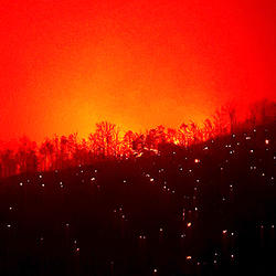
Greater Los Angeles Fires January 2025
Fires swept across the greater Los Angeles area in early January, scarring more than 50,000 acres and destroying over 15,000 structures. Exceptionally dry conditions, coupled with strong Santa Ana winds, fueled the fires.

Canada Wildfires
Smoke filled the skies over western Canada and even much of the United States in May 2023. The source was several wildfires in Alberta and British Columbia.
Landsat 8 captured this image on May 26, 2023.
Smoke filled the skies over western Canada and even much of the United States in May 2023. The source was several wildfires in Alberta and British Columbia.
Landsat 8 captured this image on May 26, 2023.
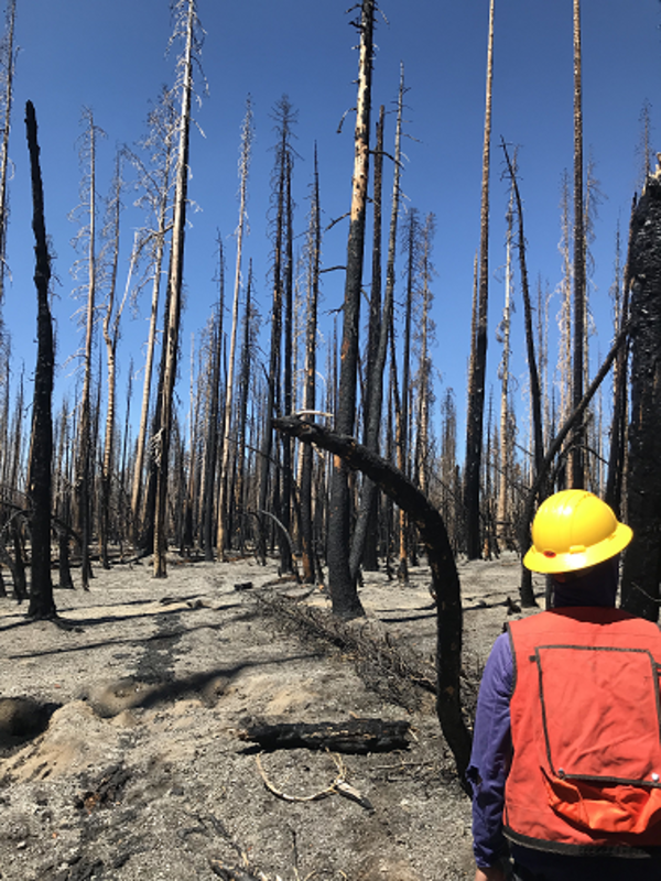
Dixie Fire, Lassen Volcanic National Park, California (2021)
Dixie Fire, Lassen Volcanic National Park, California (2021)USGS crew measuring forest conditions following the Dixie Fire in 2021. Lassen Volcanic National Park. California.
Dixie Fire, Lassen Volcanic National Park, California (2021)
Dixie Fire, Lassen Volcanic National Park, California (2021)USGS crew measuring forest conditions following the Dixie Fire in 2021. Lassen Volcanic National Park. California.

Photograph of one of the East Troublesome wildfire burn scar areas taken during a UAS mission in Colorado
Photograph of one of the East Troublesome wildfire burn scar areas taken during a UAS mission in ColoradoPhotograph of one of the East Troublesome wildfire burn scar areas taken during a UAS mission in Colorado

UAS collecting lidar over an East Troublesome Fire burn scar
UAS collecting lidar over an East Troublesome Fire burn scarIn June 2021, eight months after the East Troublesome Fire burned over 193,000 acres in Colorado, NUSO performed UAS data collection over several of the burn scars representing different fire intensity levels and fuel types.

Sampling sediment following wildfires
In August of 2020, the enormous CZU wildfire complex consumed over 85,000 acres in San Mateo and Santa Cruz Counties, leaving scarred landscapes in the hilly region. Runoff from large rainstorms in the winter months carry contaminants from the soils within these burned-out forests.
In August of 2020, the enormous CZU wildfire complex consumed over 85,000 acres in San Mateo and Santa Cruz Counties, leaving scarred landscapes in the hilly region. Runoff from large rainstorms in the winter months carry contaminants from the soils within these burned-out forests.

Wildfire at the Crossroads
The relationship between people and wildfire has always been paradoxical: fire is an essential ecological process and management tool but can also be detrimental to life and property. Consequently, fire regimes have been modified throughout history through both intentional burning to promote benefits and active suppression to reduce risks.
The relationship between people and wildfire has always been paradoxical: fire is an essential ecological process and management tool but can also be detrimental to life and property. Consequently, fire regimes have been modified throughout history through both intentional burning to promote benefits and active suppression to reduce risks.

Image of the Week - California Wildfires
Satellites have captured views of the numerous major fires burning in California.
An image acquired on November 9, 2018, from NASA’s MODIS sensor on the Terra satellite shows smoke pouring out of two major fires, the Camp Fire and the Woolsey Fire, which both ignited the day before.
Satellites have captured views of the numerous major fires burning in California.
An image acquired on November 9, 2018, from NASA’s MODIS sensor on the Terra satellite shows smoke pouring out of two major fires, the Camp Fire and the Woolsey Fire, which both ignited the day before.

AfterThomas_Wildfires_Dec2017.jpg
A Landsat image after the Thomas fire in California in 2017. This image is to be used for the after image for a before and after image.
A Landsat image after the Thomas fire in California in 2017. This image is to be used for the after image for a before and after image.

A managed wildfire burns in a Ponderosa pine stand, New Mexico
A managed wildfire burns in a Ponderosa pine stand, New MexicoA managed wildfire burns in a Ponderosa pine stand, New Mexico
A managed wildfire burns in a Ponderosa pine stand, New Mexico
A managed wildfire burns in a Ponderosa pine stand, New MexicoA managed wildfire burns in a Ponderosa pine stand, New Mexico

Monitoring fire effects at archaeological sites
Monitoring fire effects at archaeological sites provides critical information for fire planning and site preservation. Santa Fe National Forest, New Mexico, 2014.
Monitoring fire effects at archaeological sites provides critical information for fire planning and site preservation. Santa Fe National Forest, New Mexico, 2014.

A managed wildfire in New Mexico
A managed wildfire in New Mexico demonstrates application of wildland fire
science for forest restoration and risk reduction
A managed wildfire in New Mexico demonstrates application of wildland fire
science for forest restoration and risk reduction

Big Sagebrush Re-establishing 15 Years Post-wildfire Along the Boise Front Mountains
Big Sagebrush Re-establishing 15 Years Post-wildfire Along the Boise Front MountainsYoung mountain big sagebrush shown in the foreground are re-establishing in a native bunchgrass community 15 years after a fire along the Boise Front Mountains looking unto the Snake River Plain, Idaho.

Firefighters in Smoke
Firefighters surrounded by clouds of smoke and dust of the World Trade Center after the terrorist attacks of September 11, 2001. Photographer's Mate 2nd Class Jim Watson, U.S. Navy.
Firefighters surrounded by clouds of smoke and dust of the World Trade Center after the terrorist attacks of September 11, 2001. Photographer's Mate 2nd Class Jim Watson, U.S. Navy.
Related
Where can I find wildfire perimeter data? Where can I find wildfire perimeter data?
The USGS operated the Geospatial Multi-Agency Coordination (GeoMAC) website from 2000-2020. GeoMAC was the public face of all wildland fire perimeters. That site was shut down on April 30, 2020 and responsibility for wildfire information was transferred to the National Interagency Fire Center (NIFC). Data previously at "rmgsc.cr.usgs.gov/outgoing/GeoMAC/" is now at National Interagency Fire Center...
Will global warming produce more frequent and more intense wildfires? Will global warming produce more frequent and more intense wildfires?
There isn’t a direct relationship between climate change and fire, but researchers have found strong correlations between warm summer temperatures and large fire years, so there is general consensus that fire occurrence will increase with climate change. Hot, dry conditions, however, do not automatically mean fire—something needs to create the spark and actually start the fire. In some parts of...
What should I know about wildfires and debris flows? What should I know about wildfires and debris flows?
Wildland fires are inevitable in the western United States. Expansion of human development into forested areas has created a situation where wildfires can adversely affect lives and property, as can the flooding and landslides that occur in the aftermath of the fires. There is a need to develop tools and methods to identify and quantify the potential hazards posed by landslides produced from...
What are the long-term effects of climate change? What are the long-term effects of climate change?
Scientists have predicted that long-term effects of climate change will include a decrease in sea ice and an increase in permafrost thawing, an increase in heat waves and heavy precipitation, and decreased water resources in semi-arid regions. Below are some of the regional impacts of global change forecast by the Intergovernmental Panel on Climate Change: North America: Decreasing snowpack in the...
How can climate change affect natural disasters? How can climate change affect natural disasters?
With increasing global surface temperatures the possibility of more droughts and increased intensity of storms will likely occur. As more water vapor is evaporated into the atmosphere it becomes fuel for more powerful storms to develop. More heat in the atmosphere and warmer ocean surface temperatures can lead to increased wind speeds in tropical storms. Rising sea levels expose higher locations...
Greater Los Angeles Fires January 2025
Fires swept across the greater Los Angeles area in early January, scarring more than 50,000 acres and destroying over 15,000 structures. Exceptionally dry conditions, coupled with strong Santa Ana winds, fueled the fires.
Fires swept across the greater Los Angeles area in early January, scarring more than 50,000 acres and destroying over 15,000 structures. Exceptionally dry conditions, coupled with strong Santa Ana winds, fueled the fires.
Canada Wildfires
Smoke filled the skies over western Canada and even much of the United States in May 2023. The source was several wildfires in Alberta and British Columbia.
Landsat 8 captured this image on May 26, 2023.
Smoke filled the skies over western Canada and even much of the United States in May 2023. The source was several wildfires in Alberta and British Columbia.
Landsat 8 captured this image on May 26, 2023.
Dixie Fire, Lassen Volcanic National Park, California (2021)
Dixie Fire, Lassen Volcanic National Park, California (2021)USGS crew measuring forest conditions following the Dixie Fire in 2021. Lassen Volcanic National Park. California.
Dixie Fire, Lassen Volcanic National Park, California (2021)
Dixie Fire, Lassen Volcanic National Park, California (2021)USGS crew measuring forest conditions following the Dixie Fire in 2021. Lassen Volcanic National Park. California.
Photograph of one of the East Troublesome wildfire burn scar areas taken during a UAS mission in Colorado
Photograph of one of the East Troublesome wildfire burn scar areas taken during a UAS mission in ColoradoPhotograph of one of the East Troublesome wildfire burn scar areas taken during a UAS mission in Colorado
UAS collecting lidar over an East Troublesome Fire burn scar
UAS collecting lidar over an East Troublesome Fire burn scarIn June 2021, eight months after the East Troublesome Fire burned over 193,000 acres in Colorado, NUSO performed UAS data collection over several of the burn scars representing different fire intensity levels and fuel types.
Sampling sediment following wildfires
In August of 2020, the enormous CZU wildfire complex consumed over 85,000 acres in San Mateo and Santa Cruz Counties, leaving scarred landscapes in the hilly region. Runoff from large rainstorms in the winter months carry contaminants from the soils within these burned-out forests.
In August of 2020, the enormous CZU wildfire complex consumed over 85,000 acres in San Mateo and Santa Cruz Counties, leaving scarred landscapes in the hilly region. Runoff from large rainstorms in the winter months carry contaminants from the soils within these burned-out forests.
Wildfire at the Crossroads
The relationship between people and wildfire has always been paradoxical: fire is an essential ecological process and management tool but can also be detrimental to life and property. Consequently, fire regimes have been modified throughout history through both intentional burning to promote benefits and active suppression to reduce risks.
The relationship between people and wildfire has always been paradoxical: fire is an essential ecological process and management tool but can also be detrimental to life and property. Consequently, fire regimes have been modified throughout history through both intentional burning to promote benefits and active suppression to reduce risks.
Image of the Week - California Wildfires
Satellites have captured views of the numerous major fires burning in California.
An image acquired on November 9, 2018, from NASA’s MODIS sensor on the Terra satellite shows smoke pouring out of two major fires, the Camp Fire and the Woolsey Fire, which both ignited the day before.
Satellites have captured views of the numerous major fires burning in California.
An image acquired on November 9, 2018, from NASA’s MODIS sensor on the Terra satellite shows smoke pouring out of two major fires, the Camp Fire and the Woolsey Fire, which both ignited the day before.
AfterThomas_Wildfires_Dec2017.jpg
A Landsat image after the Thomas fire in California in 2017. This image is to be used for the after image for a before and after image.
A Landsat image after the Thomas fire in California in 2017. This image is to be used for the after image for a before and after image.
A managed wildfire burns in a Ponderosa pine stand, New Mexico
A managed wildfire burns in a Ponderosa pine stand, New MexicoA managed wildfire burns in a Ponderosa pine stand, New Mexico
A managed wildfire burns in a Ponderosa pine stand, New Mexico
A managed wildfire burns in a Ponderosa pine stand, New MexicoA managed wildfire burns in a Ponderosa pine stand, New Mexico
Monitoring fire effects at archaeological sites
Monitoring fire effects at archaeological sites provides critical information for fire planning and site preservation. Santa Fe National Forest, New Mexico, 2014.
Monitoring fire effects at archaeological sites provides critical information for fire planning and site preservation. Santa Fe National Forest, New Mexico, 2014.
A managed wildfire in New Mexico
A managed wildfire in New Mexico demonstrates application of wildland fire
science for forest restoration and risk reduction
A managed wildfire in New Mexico demonstrates application of wildland fire
science for forest restoration and risk reduction
Big Sagebrush Re-establishing 15 Years Post-wildfire Along the Boise Front Mountains
Big Sagebrush Re-establishing 15 Years Post-wildfire Along the Boise Front MountainsYoung mountain big sagebrush shown in the foreground are re-establishing in a native bunchgrass community 15 years after a fire along the Boise Front Mountains looking unto the Snake River Plain, Idaho.
Firefighters in Smoke
Firefighters surrounded by clouds of smoke and dust of the World Trade Center after the terrorist attacks of September 11, 2001. Photographer's Mate 2nd Class Jim Watson, U.S. Navy.
Firefighters surrounded by clouds of smoke and dust of the World Trade Center after the terrorist attacks of September 11, 2001. Photographer's Mate 2nd Class Jim Watson, U.S. Navy.
Updated Date: May 19, 2026