
Upper Midwest Environmental Sciences Center
Long Term Resource Monitoring
Ecological Status and Trends of the Upper Mississippi and Illinois Rivers
Ecological Status and Trends of the Upper Mississippi and Illinois Rivers
UMESC Activity Report for October 2025 – April 2026
Publications and Products
Publications and Products
Scientific Investigations Report
Breeding Birds of the Upper Mississippi River Floodplain Forest: One Community in a Changing Forest, 1994 to 1997
Breeding Birds of the Upper Mississippi River Floodplain Forest: One Community in a Changing Forest, 1994 to 1997
Bat Research
White-nose syndrome (WNS) caused by the fungal pathogen Pseudogymnoascus destructans (Pd)
White-nose syndrome (WNS) caused by the fungal pathogen Pseudogymnoascus destructans (Pd)
Conservation of Native Freshwater Mussels
Freshwater mussels are the most imperiled group of animals in North America, with 66% of species at risk.
Freshwater mussels are the most imperiled group of animals in North America, with 66% of species at risk.
UMRR Long Term Resource Monitoring
The LTRM is the Nation's largest river monitoring program with six remote state-operated field stations.
The LTRM is the Nation's largest river monitoring program with six remote state-operated field stations.
Upper Midwest Environmental Sciences Center
Welcome to the Upper Midwest Environmental Sciences Center (UMESC). We are proud to be one of the leading research centers conducting ecological research to support the Department of the Interior's and other local, state and federal resource agencies management of natural resources, fish, and wildlife.
News
Amphibian Week with USGS: Science for Healthy Habitats
Amphibian Week with USGS: Science for Healthy Habitats
Tackling Invasive Mussels with Science and Strategy
Tackling Invasive Mussels with Science and Strategy
WEBINAR: USGS Invasive Species Science - Innovation for a Healthy Nation
WEBINAR: USGS Invasive Species Science - Innovation for a Healthy Nation
Publications
Patterns of floodplain forest mortality and recruitment along the Upper Mississippi and Illinois Rivers: Associations with forest fragmentation and flood inundation Patterns of floodplain forest mortality and recruitment along the Upper Mississippi and Illinois Rivers: Associations with forest fragmentation and flood inundation
Context Different rates of floodplain forest recruitment and mortality can reveal important changes in ecosystem processes that drive forest dynamics, resulting in net changes in forest cover, thereby influencing a wide range of river habitat and morphological characteristics.Objectives We evaluated characteristics of forest change areas in the Upper Mississippi River System.Methods An...
Life history traits and population dynamics of Freshwater Drum across large river gradients Life history traits and population dynamics of Freshwater Drum across large river gradients
Objective Monitoring and assessment of nongame native fishes is limited, but conservation interest in these species is growing. Freshwater Drum Aplodinotus grunniens are a wide-ranging species that serve important functional roles and could serve as an indicator for similar but less common species. Our overall objectives were to quantify and compare population dynamic rates and life...
Proceedings of the Floodplain Vegetation Monitoring Workshop for the Long Term Resource Monitoring Element of the Upper Mississippi River Restoration Program, January 7–8, 2025, Moline, Illinois Proceedings of the Floodplain Vegetation Monitoring Workshop for the Long Term Resource Monitoring Element of the Upper Mississippi River Restoration Program, January 7–8, 2025, Moline, Illinois
Preface In anticipation for increased funding made possible by the Water Resources Development Act of 2020, the Upper Mississippi River Restoration (UMRR) Program identified a need to conduct river-wide assessments of floodplain vegetation. In January 2025, we assembled a group of subject matter experts to perform the following tasks:Review Upper Mississippi River Restoration’s current...
Science
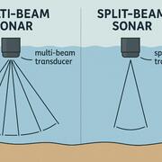
Improving hydroacoustic techniques to assess invasive carp populations in large rivers
Invasive carp, such as Bighead Carp and Silver Carp, are non-native fish that have been introduced throughout North American waterways, often through human activities. Their ability to rapidly reproduce, outcompeting native fish for food and habitat, can pose a significant threat to local ecosystems. Additionally, their large population numbers can harm commercial and recreational fishing, causing...
Riverine Acoustic Fish Telemetry (RAFT) Network
The Riverine Acoustic Fish Telemetry (RAFT™) Network is a node of the Ocean Tracking Network (OTN) and serves as a repository to access and archive acoustic fish telemetry data from projects occurring across the Mississippi River Basin. By sharing the locations of receivers and detections of member transmitters across all receivers in the Network, RAFT provides an avenue for collaboration and...

eDNA and the Efficacy of Management Actions
Environmental DNA (eDNA) is a powerful feedback tool, giving managers fast, clear, and cost-effective evidence to guide decisions and improve conservation outcomes.
By
Ecosystems Mission Area, Biological Threats and Invasive Species Research Program, Environmental Health Program, Species Management Research Program, Alaska Science Center, Columbia Environmental Research Center, Eastern Ecological Science Center, Forest and Rangeland Ecosystem Science Center, Fort Collins Science Center, Great Lakes Science Center, National Wildlife Health Center, Northern Prairie Wildlife Research Center, Northern Rocky Mountain Science Center, Pacific Island Ecosystems Research Center, Southwest Biological Science Center, Upper Midwest Environmental Sciences Center, Western Ecological Research Center (WERC), Western Fisheries Research Center, Wetland and Aquatic Research Center , Pacific Northwest Environmental DNA Laboratory