
Hydrological Alteration
Hydrological Alteration
Filter Total Items: 31
Engaging Indigenous Communities to Co-Design a Web Application to Protect Everglades Tree Islands
The USGS collaborated with the Miccosukee and Seminole Tribes to co-design a dashboard mock-up for a real-time web application that monitors tree island health in the Everglades.
Developing a Roadmap for the Future of Natural Resources in Everglades National Park
To sustain economic and ecologically viable ecosystems into the future, USGS is developing freshwater delivery targets for water flowing southward into Everglades National Park by integrating climate and sea level projections, hydrologic modeling, and ecological modeling to forecast ecosystem responses to future freshwater availability scenarios.

Integrating Remote Sensing and Numerical Modeling Technology to Detect and Manage Current and Future Harmful Algal Blooms in Louisiana’s Coastal and Tidal Waters
USGS is collaborating with partners to assess past and current CyanoHABs for the development of a predictive model and forecasting system for Lake Pontchartrain Estuary. This technology can be beneficial for informing future planning of water resource development projects, and the water management of the estuary.

A Fresh Set of Tools: New Information for Managing Fisheries During Changes in River Discharge
USGS scientists are conducting research to understand how estuary fisheries are affected by the the timing and/or magnitude of freshwater discharge into Lake Pontchartrain in Louisiana.

Vertical Control of Rod Surface Elevation Table (RSET) Benchmarks to Assess Implications of Sea-Level Rise within Texas Coastal Refuges
The USGS will establish Rod Surface Elevation Tables at five National Wildlife Refuges on the Texas coast. This work will support climate adaptation and resilience planning by identifying areas susceptible to loss and degradation due to sea-level rise and extreme climatic events along the Texas Gulf Coast.

Understanding Ecosystem Response and Infrastructure Vulnerability to Sea-Level Rise for Gulf Islands National Seashore
USGS researchers will will survey elevation and vegetation in wetlands and vegetated dunes on Horn, Petite Bois, and Ship Islands; Correct the best available lidar-based digital elevation model; estimate inundation for the Gulf Islands National Seashore under various water levels and relative sea-level rise scenarios; and quantify and predict potential marsh migration for the Gulf Islands National...

Coastal Wetland Vulnerability to Climate Change and Sea-Level Rise: Understanding Ecological Thresholds and Ecosystem Transformations
Eighteen USGS coastal scientists from all four coasts of the conterminous United States are working together to advance the understanding of climate change and sea-level rise impacts to coastal wetlands.
By
California Water Science Center, Chesapeake Bay Activities, Eastern Ecological Science Center, Florence Bascom Geoscience Center, Great Lakes Science Center, Pacific Coastal and Marine Science Center, St. Petersburg Coastal and Marine Science Center, Western Ecological Research Center (WERC), Western Geographic Science Center, Wetland and Aquatic Research Center , Woods Hole Coastal and Marine Science Center

Decision Support Tools for Everglades Ecosystem-Based Management
The USGS Joint Ecosystem Modeling team will work with partners to identify and develop decision support tools for Everglades water management.

Evaluating Population Viability and Habitat Suitability for the Cape Sable Seaside Sparrow Under Future Climate and Management Conditions
WARC will assess Cape Sable seaside sparrow population response and viability under different management and habitat change scenarios. The USGS EverSparrow model will be run on future scenarios, and differences in the predicted probability of presence and the efficacy of varying conservation strategies will be evaluated.

Vulnerability of Mole Skinks to Sea-Level Rise
Mole skinks that occur on Florida’s islands rely on sand beaches, beach berms, and dunes, making them particularly vulnerable to sea level rise and storm surge. USGS researchers predicted the impacts of sea level rise and storm surge on habitat for the Florida Keys mole skink ( Plestiodon egregius egregius), the Cedar Key mole skink ( P. e. insularis), and the Egmont Key mole skink (known from a...

Predicting Sea-Level Rise Impacts to Barrier Island Habitats
Researchers at WARC are determining if temporal mismatches between digital elevation models and land cover data can impact estimates of inundation of beach habitat for barrier islands and low-lying beaches off the Gulf Coast of Florida.

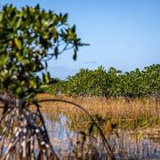
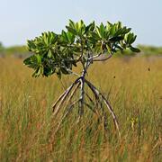
Synthesizing Surface Elevation Change Data to Advance Understanding of Sea-level Rise Impacts to Mangrove Forests and Salt Marshes
USGS and NPS partners are working together to analyze and synthesize long-term SET-MH measurements to improve understanding of coastal wetland soil elevation change and ecological responses to sea-level rise.