
Climate Change
Climate Change
The National Climate Change Viewer
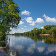
Variability in the Earth's climate system affects the location and health of terrestrial and marine ecosystems; the distribution, quantity, and quality of water resources; and the sustainability of human societies. The Ecosystems Land Change Science Program applies geological, geochemical, ecological, and other analyses to document rates, amplitudes, causes, and impacts of climate change.
Filter Total Items: 47

Connections between Forested and Urban Landscapes and Implications for Water Supply
Downstream communities rely upon forested mountains for high-quality water needed for water supply and agricultural irrigation. However, these forests are vulnerable to disturbances such as wildfire, drought, and flood, and are also affected by air pollution from adjacent urban and agricultural lands. Interactions between forested, urban, and agricultural landscapes can have substantial impacts on...

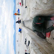
Glaciers and Landscape Change
Mountain glaciers are dynamic reservoirs of frozen water, deeply interconnected with their surrounding ecosystems. Glacier change in North America has major societal impacts, including to water resources, natural hazard risk, tourism disruption, fisheries, and global sea level change. Understanding and quantifying precise connections between changing glaciers, the surrounding landscape and climate...
How Science Helps Manage Changing Water Availability and Quality: Droughts, Floods, Avalanches and More
Droughts, floods, and avalanches are extreme events in the water cycle that can have catastrophic and lasting impacts on ecosystems and society. In addition to these extreme events, human changes to the landscape (including land use changes) can have substantial impacts on freshwater resources as well. Science from the USGS Ecosystems Land Change Science Program helps managers and decision-makers...
Research Enhancing Park Recreation and Tourism
Scientists from the USGS Ecosystems Land Change Science Program work hand-in-hand with park managers to support abundant and enduring outdoor recreation and tourism opportunities in the Nation’s national parks.

SBSC: Providing Unbiased Actionable Science & Information to Support Natural Resource Management Needs of the U.S. & Department of the Interior Priorities
The U.S. Geological Survey Southwest Biological Science Center (SBSC) is uniquely positioned in the Colorado River Basin to provide sound information, specialized expertise, and innovative tools to support the management and sustained use of natural resources on public and Tribal lands in the Southwest U.S.
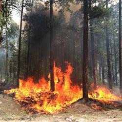
Reducing Wildfire Risks with Science
Hotter and drier conditions are making wildfires more intense and destructive across the United States. Science from the USGS Ecosystems Land Change Science Program informs local to national reduction of wildfire hazards, which saves money in avoided losses and fire suppression costs, as well as saves human lives.

Regional Assessment of Drought Impacts on Soils (RADIS)
Soils are the foundation of terrestrial ecosystems. They provide critical services including supplying a substrate and the nutrients necessary for plant growth, retaining moisture from precipitation, filtering contaminants from percolating waters, and acting as a sink of carbon. Healthy soils are key to sustaining both human and ecosystem health. However, global- and regional-scale disturbances...

Holocene and Modern Drivers of Wetland Change
On a global scale, wetland systems are affected by precipitation extremes, changing sea level, and population growth, influencing their capacity to moderate storm surge, filter contaminants, and provide habitats for fish and wildlife. This research takes a long-term perspective on the resilience of wetlands to a range of environmental- and human-induced changes and supports wetland management by...

Did we start the fire? Drought, Fire and Humans
The past decade encompasses some of the most extensive fire activity in recorded history. An area the size of Vermont (~24,000 km2) burned in a single Siberian fire in the summer of 2019 (Kehrwald et al., 2020 and references therein) while Australia, Indonesia and the Amazon have all experienced their most intense fires in recorded history (van Wees et al, 2021 and references therein). As more...

Environmental streamflows in the United States: historical patterns and predictions
The term environmental streamflows refers to the magnitude, frequency, seasonal timing, duration, and rate of change of streamflows needed to sustain freshwater and estuary ecosystems and human wellbeing. It is important that environmental streamflow assessments by water managers consider changes in climate, land use, and water management; this cannot be done effectively without understanding...

Interdisciplinary Modeling of Land Use, Climate, and Hydrologic Processes
This project focuses on development of new interdisciplinary modeling capabilities of long-term time series that capture interactions among climate, land use, water use, and water availability. Research builds on expanding the USGS Forecasting Scenarios of Land Use (FORE-SCE) model and integrating with spatially explicit models from other disciplines. Interdisciplinary models will be co-developed...

Wet Snow Avalanche Research
Wet snow avalanches, including both wet slab and glide avalanches, are dangerous and can be particularly difficult to predict because they are relatively poorly understood compared to dry snow avalanches. They pose significant risk to human life and infrastructure in mountainous areas throughout the world. Wet snow avalanches are caused by weakening in the strength of the snowpack, often triggered...