
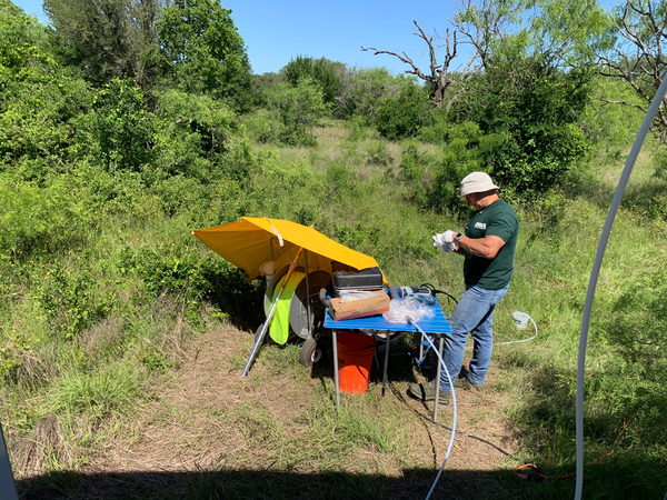
Oklahoma-Texas Water Science Center Hydrologic Technician Dwight Sparks purges a monitoring well in Austin Texas to ensure stable field parameters before collecting a groundwater sample.
MaryLynn Musgrove
MaryLynn Musgrove is a research physical scientist with the USGS Oklahoma-Texas Water Science Center.
MaryLynn conducts research applying geochemical tools and tracers to better understand water resources. Broadly trained in hydrogeology and sedimentary and isotope geochemistry, MaryLynn works across temporal and spatial scales, often with a focus on carbonate (karst) aquifers.
MaryLynn joined the Oklahoma-Texas Water Science Center in 2006. She also serves the USGS Water Resources Mission Area as the acting Chief of Staff for the Office of the Chief Operating Office.
Science and Products

Outlining Potential Health Effects of Exposure to Critical Elements: From Chemical Structure to Adverse Outcome Pathways
The Federal Government was charged with ensuring a reliable supply of critical minerals from within the U.S., and to further this policy in a safe and environmentally responsible manner by identifying new sources of critical elements. The objective of this research is to delineate anticipated adverse outcome pathways for the critical elements.

Groundwater Quality—Current Conditions and Changes Through Time
Is groundwater the source of your drinking water? The USGS is assessing the quality of groundwater used for public supply using newly collected data along with existing water-quality data. Learn more about this invisible, vital resource so many of us depend on.

Rapid Fluctuations in Groundwater Quality
We think of groundwater as moving slowly, and groundwater quality as changing slowly—over decades or even centuries. But in some parts of some aquifers, groundwater quality can fluctuate rapidly, sometimes over just a few hours. Are such changes part of a long-term trend, or just part of a short-term cycle? And what does that mean for suitability for drinking?

National Water-Quality Assessment Project in Texas - Groundwater Activities
The USGS National Water-Quality Assessment (NAWQA) Project was established by Congress in 1992 to answer the following question: What is the status of the Nation’s water quality and is it getting better or worse? Since 1992, NAWQA has been a primary source of nationally consistent data and information on the quality of the Nation’s streams and groundwater. Data and information obtained from...

Edwards Aquifer Recharge Zone Surface-water and Groundwater Interaction
The effects of urbanization across the recharge zone in Bexar County and potential impact on the water quality in the Edwards aquifer is a topic of specific concern for the City of San Antonio. The USGS Oklahoma-Texas Water Science Center is simultaneously collecting water-quality data from surface-water runoff sites and paired shallow groundwater wells within the recharge zone of the Edwards...
National Water-Quality Assessment Project in Texas - Surface Water Activities
The USGS National Water-Quality Assessment (NAWQA) Project was established by Congress in 1992 to answer the following question: What is the status of the Nation’s water quality and is it getting better or worse? Since 1992, NAWQA has been a primary source of nationally consistent data and information on the quality of the Nation’s streams and groundwater. Data and information obtained from...

Hydrogeologic and Geochemical Investigation of the Trinity and Northern Segment Edwards Aquifers
The USGS Oklahoma-Texas Water Science Center, in cooperation with the Clearwater Underground Water Conservation District and Bell County Adaptive Management Coalition, is evaluating the hydrogeology and water quality of the Northern segment of the Edwards and Trinity aquifers in Bell County to provide regional resource managers responsible for regulation of water use and drought management...

Urban Waters Federal Partnership - Edwards Aquifer Recharge Zone Monitoring Network
The USGS Oklahoma-Texas Water Science Center is implementing a more complete and integrated monitoring network for the Edwards aquifer to improve the understanding of aquifer water quality and establish a baseline for measuring future water-quality changes.

Edwards Aquifer Studies in Texas
The Edwards aquifer in south-central Texas is one of the most productive aquifers in the Nation and is the primary source of water for the rapidly growing San Antonio area. Springs issuing from the Edwards aquifer provide habitat for several threatened and endangered species, serve as locations for recreational activities, and supply downstream users. The USGS Oklahoma-Texas Water Science Center...
Groundwater quality measurements at a mobile lab
Oklahoma-Texas Water Science Center Hydrologic Technician Dwight Sparks purges a monitoring well in Austin Texas to ensure stable field parameters before collecting a groundwater sample.
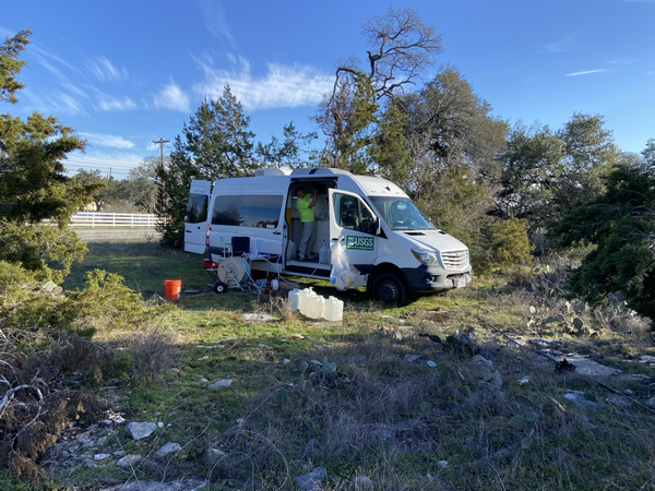
Mobile groundwater quality lab and USGS van
Oklahoma-Texas Water Science Center Hydrologic Technician Sam Matschek processes a groundwater sample at a monitoring well in Austin Texas. This groundwater sampling effort was to quantify geogenic contaminations in groundwater aquifers.
Oklahoma-Texas Water Science Center Hydrologic Technician Sam Matschek processes a groundwater sample at a monitoring well in Austin Texas. This groundwater sampling effort was to quantify geogenic contaminations in groundwater aquifers.

Strontium measured in wells tapping U.S. principal aquifers
Strontium measured in wells tapping U.S. principal aquifersConcentrations of strontium in samples of groundwater from drinking-water wells and shallow monitoring wells.
Strontium measured in wells tapping U.S. principal aquifers
Strontium measured in wells tapping U.S. principal aquifersConcentrations of strontium in samples of groundwater from drinking-water wells and shallow monitoring wells.

Sampling Dust From Sealcoated Pavement
USGS researchers collect samples of dust from a sealcoated parking lot for analysis of polycyclic aromatic hydrocarbons (PAHs). PAH concentrations in dust swept from coal-tar-sealcoated parking lots are 100s to 1000s of times higher than those swept from parking lots with other types of surfaces.
USGS researchers collect samples of dust from a sealcoated parking lot for analysis of polycyclic aromatic hydrocarbons (PAHs). PAH concentrations in dust swept from coal-tar-sealcoated parking lots are 100s to 1000s of times higher than those swept from parking lots with other types of surfaces.
Science and Products
Outlining Potential Health Effects of Exposure to Critical Elements: From Chemical Structure to Adverse Outcome Pathways
The Federal Government was charged with ensuring a reliable supply of critical minerals from within the U.S., and to further this policy in a safe and environmentally responsible manner by identifying new sources of critical elements. The objective of this research is to delineate anticipated adverse outcome pathways for the critical elements.
Groundwater Quality—Current Conditions and Changes Through Time
Is groundwater the source of your drinking water? The USGS is assessing the quality of groundwater used for public supply using newly collected data along with existing water-quality data. Learn more about this invisible, vital resource so many of us depend on.
Rapid Fluctuations in Groundwater Quality
We think of groundwater as moving slowly, and groundwater quality as changing slowly—over decades or even centuries. But in some parts of some aquifers, groundwater quality can fluctuate rapidly, sometimes over just a few hours. Are such changes part of a long-term trend, or just part of a short-term cycle? And what does that mean for suitability for drinking?
National Water-Quality Assessment Project in Texas - Groundwater Activities
The USGS National Water-Quality Assessment (NAWQA) Project was established by Congress in 1992 to answer the following question: What is the status of the Nation’s water quality and is it getting better or worse? Since 1992, NAWQA has been a primary source of nationally consistent data and information on the quality of the Nation’s streams and groundwater. Data and information obtained from...
Edwards Aquifer Recharge Zone Surface-water and Groundwater Interaction
The effects of urbanization across the recharge zone in Bexar County and potential impact on the water quality in the Edwards aquifer is a topic of specific concern for the City of San Antonio. The USGS Oklahoma-Texas Water Science Center is simultaneously collecting water-quality data from surface-water runoff sites and paired shallow groundwater wells within the recharge zone of the Edwards...
National Water-Quality Assessment Project in Texas - Surface Water Activities
The USGS National Water-Quality Assessment (NAWQA) Project was established by Congress in 1992 to answer the following question: What is the status of the Nation’s water quality and is it getting better or worse? Since 1992, NAWQA has been a primary source of nationally consistent data and information on the quality of the Nation’s streams and groundwater. Data and information obtained from...
Hydrogeologic and Geochemical Investigation of the Trinity and Northern Segment Edwards Aquifers
The USGS Oklahoma-Texas Water Science Center, in cooperation with the Clearwater Underground Water Conservation District and Bell County Adaptive Management Coalition, is evaluating the hydrogeology and water quality of the Northern segment of the Edwards and Trinity aquifers in Bell County to provide regional resource managers responsible for regulation of water use and drought management...
Urban Waters Federal Partnership - Edwards Aquifer Recharge Zone Monitoring Network
The USGS Oklahoma-Texas Water Science Center is implementing a more complete and integrated monitoring network for the Edwards aquifer to improve the understanding of aquifer water quality and establish a baseline for measuring future water-quality changes.
Edwards Aquifer Studies in Texas
The Edwards aquifer in south-central Texas is one of the most productive aquifers in the Nation and is the primary source of water for the rapidly growing San Antonio area. Springs issuing from the Edwards aquifer provide habitat for several threatened and endangered species, serve as locations for recreational activities, and supply downstream users. The USGS Oklahoma-Texas Water Science Center...
Groundwater quality measurements at a mobile lab
Oklahoma-Texas Water Science Center Hydrologic Technician Dwight Sparks purges a monitoring well in Austin Texas to ensure stable field parameters before collecting a groundwater sample.
Oklahoma-Texas Water Science Center Hydrologic Technician Dwight Sparks purges a monitoring well in Austin Texas to ensure stable field parameters before collecting a groundwater sample.
Mobile groundwater quality lab and USGS van
Oklahoma-Texas Water Science Center Hydrologic Technician Sam Matschek processes a groundwater sample at a monitoring well in Austin Texas. This groundwater sampling effort was to quantify geogenic contaminations in groundwater aquifers.
Oklahoma-Texas Water Science Center Hydrologic Technician Sam Matschek processes a groundwater sample at a monitoring well in Austin Texas. This groundwater sampling effort was to quantify geogenic contaminations in groundwater aquifers.
Strontium measured in wells tapping U.S. principal aquifers
Strontium measured in wells tapping U.S. principal aquifersConcentrations of strontium in samples of groundwater from drinking-water wells and shallow monitoring wells.
Strontium measured in wells tapping U.S. principal aquifers
Strontium measured in wells tapping U.S. principal aquifersConcentrations of strontium in samples of groundwater from drinking-water wells and shallow monitoring wells.
Sampling Dust From Sealcoated Pavement
USGS researchers collect samples of dust from a sealcoated parking lot for analysis of polycyclic aromatic hydrocarbons (PAHs). PAH concentrations in dust swept from coal-tar-sealcoated parking lots are 100s to 1000s of times higher than those swept from parking lots with other types of surfaces.
USGS researchers collect samples of dust from a sealcoated parking lot for analysis of polycyclic aromatic hydrocarbons (PAHs). PAH concentrations in dust swept from coal-tar-sealcoated parking lots are 100s to 1000s of times higher than those swept from parking lots with other types of surfaces.