
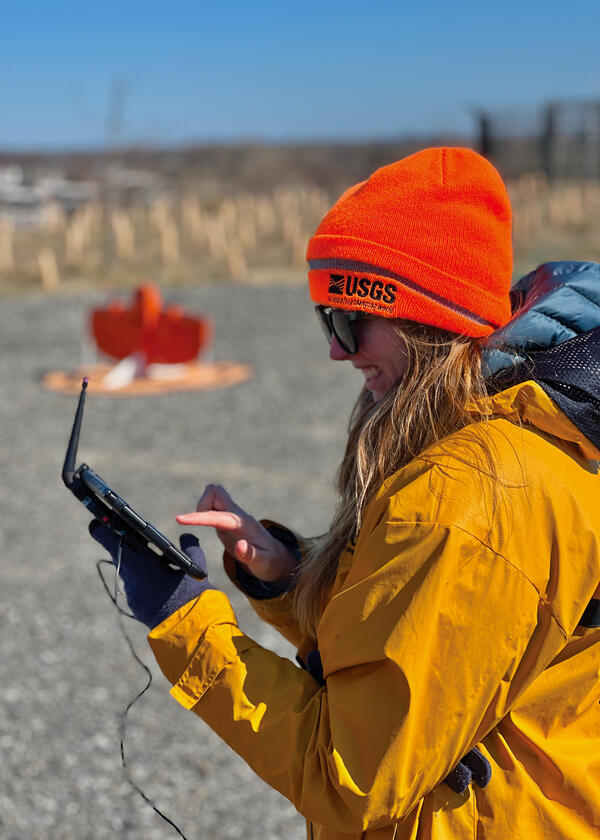
Jennifer Cramer is preparing a wingtra lidar flight at the Darby Creek landfill Superfund site (Philadelphia skyline is visible on the horizon) on March 27, 2025. sUAS, also known as a drone, is being used to model morphological changes in the tidal creek and adjacent landfill with lidar sensors, potential contaminated groundwater seeps are identified using th
Sandra M Brosnahan
Sandy Brosnahan is a Physical Scientist with the Woods Hole Coastal and Marine Science Center Aerial Imaging and Mapping Group.
Science and Products

DUNEX Pea Island Experiment
The DUring Nearshore Event eXperiment (DUNEX) is an aggregation of multiple scientific organizations collaborating to increase understanding of nearshore processes. The U.S. Geological Survey (USGS) has chosen Pea Island National Wildlife Refuge as a study location to investigate and characterize the magnitude and timing of changes to coastal morphology (i.e., dunes, shorelines), bathymetry, and...

USGS DUNEX Operations on the Outer Banks
DUring Nearshore Event eXperiment (DUNEX) is a multi-agency, academic, and non-governmental organization (NGO) collaborative community experiment designed to study nearshore coastal processes during storm events. The experiment began in 2019 and is scheduled for completion in the fall of 2021. USGS participation in DUNEX will contribute new measurements and models that will increase our...

Estuarine Processes, Hazards, and Ecosystems
Estuarine processes, hazards, and ecosystems describes several interdisciplinary projects that aim to quantify and understand estuarine processes through observations and numerical modeling. Both the spatial and temporal scales of these mechanisms are important, and therefore require modern instrumentation and state-of-the-art hydrodynamic models. These projects are led from the U.S. Geological...

Aerial Imaging and Mapping
The Aerial Imaging and Mapping group (AIM), at the U.S. Geological Survey Woods (USGS) Hole Coastal and Marine Science Center provides UAS services to scientists to advance the science mission of the Coastal and Marine Geology Program. Scientists at the Woods Hole Coastal and Marine Science Center have been using UASs to acquire imagery of coastal and wetland environments, which is then used to...

Coastal Model Applications and Field Measurements
Numerical models are used by scientists, engineers, coastal managers, and the public to understand and predict processes in the coastal ocean. This project supports the development and application of open-source coastal models and has several objectives: 1) improve the code of numerical sediment-transport models by implementing new or improved algorithms; 2) obtain measurements of coastal ocean...

Estuarine Processes Tidal Wetlands
Tidal wetlands are an important geomorphic and ecological feature of the coastal zone. Our projects deal with the physical forcings that affect wetland stability over event-to-annual timescales, including wave attack, sediment supply, and sea-level rise.
Estuarine Processes Tidal Wetlands
Tidal wetlands are an important geomorphic and ecological feature of the coastal zone. Our projects deal with the physical forcings that affect wetland stability over event-to-annual timescales, including wave attack, sediment supply, and sea-level rise.
Estuarine Processes Tidal Wetlands
Tidal wetlands are an important geomorphic and ecological feature of the coastal zone. Our projects deal with the physical forcings that affect wetland stability over event-to-annual timescales, including wave attack, sediment supply, and sea-level rise.
Estuarine Processes Tidal Wetlands
Tidal wetlands are an important geomorphic and ecological feature of the coastal zone. Our projects deal with the physical forcings that affect wetland stability over event-to-annual timescales, including wave attack, sediment supply, and sea-level rise.
Filter Total Items: 31
Researcher prepares a wingtra lidar flight
Jennifer Cramer is preparing a wingtra lidar flight at the Darby Creek landfill Superfund site (Philadelphia skyline is visible on the horizon) on March 27, 2025. sUAS, also known as a drone, is being used to model morphological changes in the tidal creek and adjacent landfill with lidar sensors, potential contaminated groundwater seeps are identified using th
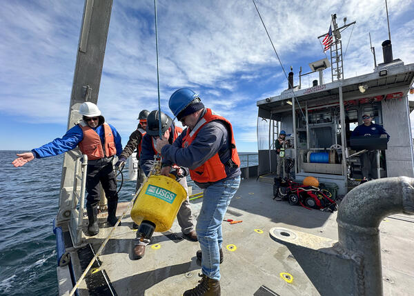
Researchers recover oceanographic instruments
Researchers Chris Sherwood, Bo Bales, Eric Marsjanik and Steve Suttles from the Woods Hole Coastal and Marine Science Center recover oceanographic instruments that measured waves, currents, and water levels off Cape Cod for three months this winter.
Researchers Chris Sherwood, Bo Bales, Eric Marsjanik and Steve Suttles from the Woods Hole Coastal and Marine Science Center recover oceanographic instruments that measured waves, currents, and water levels off Cape Cod for three months this winter.

Chris Sherwood, Athina Lange, and Jin-Si Over look at a monitor hooked up to the CoastCams overlooking Marconi Beach on Cape Cod National Seashore
Chris Sherwood, Athina Lange, and Jin-Si Over look at a monitor hooked up to the CoastCams overlooking Marconi Beach on Cape Cod National SeashoreChris Sherwood, Athina Lange, and Jin-Si Over look at a monitor hooked up to the CoastCams overlooking Marconi Beach on Cape Cod National Seashore. They are aligning the two stationary video cameras so there is a slight overlap in the look angle.
Retrieving ADCPs
Pat Berube and Eric Moore traveled to CT to help the NY water science office retrieve some ADCPs.
Pat Berube and Eric Moore traveled to CT to help the NY water science office retrieve some ADCPs.

sUAS at Darby Creek Superfund Site
Preliminary lidar data collected in the John Heinz Wildlife Refuge as a baseline for future topography change.
Preliminary lidar data collected in the John Heinz Wildlife Refuge as a baseline for future topography change.

sUAS at Darby Creek Superfund Site
Preliminary lidar data collected in the John Heinz Wildlife Refuge as a baseline for future topography change.
Preliminary lidar data collected in the John Heinz Wildlife Refuge as a baseline for future topography change.

sUAS at Darby Creek Superfund Site
USGS sUAS pilots with Josh Barber from the EPA and a sUAS with the lidar payload mounted and ready to fly over the John Heinz Wildlife Refuge.
USGS sUAS pilots with Josh Barber from the EPA and a sUAS with the lidar payload mounted and ready to fly over the John Heinz Wildlife Refuge.

sUAS at Darby Creek Superfund Site
ish and Wildlife personnel participating in a demonstration by the WHCMSC about using sUAS to collect remotely sensed data.
ish and Wildlife personnel participating in a demonstration by the WHCMSC about using sUAS to collect remotely sensed data.

sUAS at Darby Creek Superfund Site
A preliminary elevation model created by flying sUAS with a lidar scanner over the ClearView landfill.
A preliminary elevation model created by flying sUAS with a lidar scanner over the ClearView landfill.

sUAS at Darby Creek Superfund Site
Fish and Wildlife personnel participating in a demonstration by the WHCMSC about using sUAS to collect remotely sensed data.
Fish and Wildlife personnel participating in a demonstration by the WHCMSC about using sUAS to collect remotely sensed data.

sUAS at Darby Creek Superfund Site
Jin-Si Over (WHCMSC) and Chris Gazoorian (NYWSC) preparing to fly the YellowScan Mapper+ to collect lidar data on the ClearView Landfill.
Jin-Si Over (WHCMSC) and Chris Gazoorian (NYWSC) preparing to fly the YellowScan Mapper+ to collect lidar data on the ClearView Landfill.

Collecting pre-restoration LiDAR and thermal survey data
Collecting pre-restoration LiDAR and thermal survey dataIn July and October, Jen Cramer and Jin-Si Over assisted USGS UAS pilots from NUSO and Fort Collins to collect pre-restoration LiDAR and thermal survey data for the Vermillion River on the Kootenai National Forest in Montana before construction begins to improve Bull Trout habitat.

Assateague Island National Seashore
sUAS coastal Imagery collected by the Woods Hole Coastal and Marine Science Center Aerial Imaging and Mapping group (AIM) at Assateague Island National Seashore October 10-14th, 2022.
sUAS coastal Imagery collected by the Woods Hole Coastal and Marine Science Center Aerial Imaging and Mapping group (AIM) at Assateague Island National Seashore October 10-14th, 2022.
Science and Products
DUNEX Pea Island Experiment
The DUring Nearshore Event eXperiment (DUNEX) is an aggregation of multiple scientific organizations collaborating to increase understanding of nearshore processes. The U.S. Geological Survey (USGS) has chosen Pea Island National Wildlife Refuge as a study location to investigate and characterize the magnitude and timing of changes to coastal morphology (i.e., dunes, shorelines), bathymetry, and...
USGS DUNEX Operations on the Outer Banks
DUring Nearshore Event eXperiment (DUNEX) is a multi-agency, academic, and non-governmental organization (NGO) collaborative community experiment designed to study nearshore coastal processes during storm events. The experiment began in 2019 and is scheduled for completion in the fall of 2021. USGS participation in DUNEX will contribute new measurements and models that will increase our...
Estuarine Processes, Hazards, and Ecosystems
Estuarine processes, hazards, and ecosystems describes several interdisciplinary projects that aim to quantify and understand estuarine processes through observations and numerical modeling. Both the spatial and temporal scales of these mechanisms are important, and therefore require modern instrumentation and state-of-the-art hydrodynamic models. These projects are led from the U.S. Geological...
Aerial Imaging and Mapping
The Aerial Imaging and Mapping group (AIM), at the U.S. Geological Survey Woods (USGS) Hole Coastal and Marine Science Center provides UAS services to scientists to advance the science mission of the Coastal and Marine Geology Program. Scientists at the Woods Hole Coastal and Marine Science Center have been using UASs to acquire imagery of coastal and wetland environments, which is then used to...
Coastal Model Applications and Field Measurements
Numerical models are used by scientists, engineers, coastal managers, and the public to understand and predict processes in the coastal ocean. This project supports the development and application of open-source coastal models and has several objectives: 1) improve the code of numerical sediment-transport models by implementing new or improved algorithms; 2) obtain measurements of coastal ocean...
Estuarine Processes Tidal Wetlands
Tidal wetlands are an important geomorphic and ecological feature of the coastal zone. Our projects deal with the physical forcings that affect wetland stability over event-to-annual timescales, including wave attack, sediment supply, and sea-level rise.
Estuarine Processes Tidal Wetlands
Tidal wetlands are an important geomorphic and ecological feature of the coastal zone. Our projects deal with the physical forcings that affect wetland stability over event-to-annual timescales, including wave attack, sediment supply, and sea-level rise.
Estuarine Processes Tidal Wetlands
Tidal wetlands are an important geomorphic and ecological feature of the coastal zone. Our projects deal with the physical forcings that affect wetland stability over event-to-annual timescales, including wave attack, sediment supply, and sea-level rise.
Estuarine Processes Tidal Wetlands
Tidal wetlands are an important geomorphic and ecological feature of the coastal zone. Our projects deal with the physical forcings that affect wetland stability over event-to-annual timescales, including wave attack, sediment supply, and sea-level rise.
Filter Total Items: 31
Researcher prepares a wingtra lidar flight
Jennifer Cramer is preparing a wingtra lidar flight at the Darby Creek landfill Superfund site (Philadelphia skyline is visible on the horizon) on March 27, 2025. sUAS, also known as a drone, is being used to model morphological changes in the tidal creek and adjacent landfill with lidar sensors, potential contaminated groundwater seeps are identified using th
Jennifer Cramer is preparing a wingtra lidar flight at the Darby Creek landfill Superfund site (Philadelphia skyline is visible on the horizon) on March 27, 2025. sUAS, also known as a drone, is being used to model morphological changes in the tidal creek and adjacent landfill with lidar sensors, potential contaminated groundwater seeps are identified using th
Researchers recover oceanographic instruments
Researchers Chris Sherwood, Bo Bales, Eric Marsjanik and Steve Suttles from the Woods Hole Coastal and Marine Science Center recover oceanographic instruments that measured waves, currents, and water levels off Cape Cod for three months this winter.
Researchers Chris Sherwood, Bo Bales, Eric Marsjanik and Steve Suttles from the Woods Hole Coastal and Marine Science Center recover oceanographic instruments that measured waves, currents, and water levels off Cape Cod for three months this winter.
Chris Sherwood, Athina Lange, and Jin-Si Over look at a monitor hooked up to the CoastCams overlooking Marconi Beach on Cape Cod National Seashore
Chris Sherwood, Athina Lange, and Jin-Si Over look at a monitor hooked up to the CoastCams overlooking Marconi Beach on Cape Cod National SeashoreChris Sherwood, Athina Lange, and Jin-Si Over look at a monitor hooked up to the CoastCams overlooking Marconi Beach on Cape Cod National Seashore. They are aligning the two stationary video cameras so there is a slight overlap in the look angle.
Retrieving ADCPs
Pat Berube and Eric Moore traveled to CT to help the NY water science office retrieve some ADCPs.
Pat Berube and Eric Moore traveled to CT to help the NY water science office retrieve some ADCPs.
sUAS at Darby Creek Superfund Site
Preliminary lidar data collected in the John Heinz Wildlife Refuge as a baseline for future topography change.
Preliminary lidar data collected in the John Heinz Wildlife Refuge as a baseline for future topography change.
sUAS at Darby Creek Superfund Site
Preliminary lidar data collected in the John Heinz Wildlife Refuge as a baseline for future topography change.
Preliminary lidar data collected in the John Heinz Wildlife Refuge as a baseline for future topography change.
sUAS at Darby Creek Superfund Site
USGS sUAS pilots with Josh Barber from the EPA and a sUAS with the lidar payload mounted and ready to fly over the John Heinz Wildlife Refuge.
USGS sUAS pilots with Josh Barber from the EPA and a sUAS with the lidar payload mounted and ready to fly over the John Heinz Wildlife Refuge.
sUAS at Darby Creek Superfund Site
ish and Wildlife personnel participating in a demonstration by the WHCMSC about using sUAS to collect remotely sensed data.
ish and Wildlife personnel participating in a demonstration by the WHCMSC about using sUAS to collect remotely sensed data.
sUAS at Darby Creek Superfund Site
A preliminary elevation model created by flying sUAS with a lidar scanner over the ClearView landfill.
A preliminary elevation model created by flying sUAS with a lidar scanner over the ClearView landfill.
sUAS at Darby Creek Superfund Site
Fish and Wildlife personnel participating in a demonstration by the WHCMSC about using sUAS to collect remotely sensed data.
Fish and Wildlife personnel participating in a demonstration by the WHCMSC about using sUAS to collect remotely sensed data.
sUAS at Darby Creek Superfund Site
Jin-Si Over (WHCMSC) and Chris Gazoorian (NYWSC) preparing to fly the YellowScan Mapper+ to collect lidar data on the ClearView Landfill.
Jin-Si Over (WHCMSC) and Chris Gazoorian (NYWSC) preparing to fly the YellowScan Mapper+ to collect lidar data on the ClearView Landfill.
Collecting pre-restoration LiDAR and thermal survey data
Collecting pre-restoration LiDAR and thermal survey dataIn July and October, Jen Cramer and Jin-Si Over assisted USGS UAS pilots from NUSO and Fort Collins to collect pre-restoration LiDAR and thermal survey data for the Vermillion River on the Kootenai National Forest in Montana before construction begins to improve Bull Trout habitat.
Assateague Island National Seashore
sUAS coastal Imagery collected by the Woods Hole Coastal and Marine Science Center Aerial Imaging and Mapping group (AIM) at Assateague Island National Seashore October 10-14th, 2022.
sUAS coastal Imagery collected by the Woods Hole Coastal and Marine Science Center Aerial Imaging and Mapping group (AIM) at Assateague Island National Seashore October 10-14th, 2022.