An official website of the United States government
Here's how you know
Official websites use .gov
A .gov website belongs to an official government organization in the United States.
Secure .gov websites use HTTPS
A lock () or https:// means you’ve safely connected to the .gov website. Share sensitive information only on official, secure websites.
Landsat Updates are prepared periodically and distributed electronically to provide information about Landsat activities and related topics of interest.
Landsat 9 handover between USGS Earth Resources Observation and Science and NASA.
On August 11, 2022, leaders from the U.S. Geological Survey, the National Aeronautics and Space Administration (NASA), and the Sioux Falls community assembled at the USGS Earth Resources Observation and Science (EROS) Center to celebrate the handover of the management of the Landsat 9 Mission from NASA to the USGS. This celebration marks fifty years of cooperation between the agencies to provide continuous Earth imaging. NASA designs and launches the satellites, and the USGS is responsible for the archiving and distribution of data acquired by the satellites. Read more about the special day on the Landsat Missions Website.
For the first time in Landsat Mission history, three orbiting Landsat satellites are providing valuable data to users. September 27, 2021, brought the exciting and successful launch of Landsat 9 which joined the already orbiting satellites of Landsat 7, launched in 1999, and Landsat 8, launched in 2013. Data from all Landsat missions are available for download from Earth Explorer, LandsatLook, and the commercial cloud.
Unique and handy tools allow users to determine when Landsats 7–9 are crossing an area of interest or how many scenes are available for your study area. The Landsat Acquisition page allows users to display Landsat acquisition paths for any day and download a file that list the paths that were acquired. The Landsat Archive Dashboard can determine the number of scenes available for a study area. The dashboard allows users to select an area of interest and filter by multiple categories such as satellite, year, or processing level, and then output the scene IDs as a CSV file.
A recent publication provides the analysis results from the Landsat 8 and Landsat 9 underfly activities that took place in late 2021.
From November 12–17, 2021, the Landsat 8 and Landsat 9 satellites engaged in an underfly exercise that allowed for a unique calibration opportunity at the start of the Landsat 9 on-orbit mission. Early in the mission, Landsat 9 drifted in its orbit and allowed for the near-coincident collection of data with Landsat 8. This near-coincident image acquisition decreased the temporal changes between data acquired by the two satellites. Toward the end of the underfly event, the Landsat 9 spacecraft pointed off-nadir during several descending passes to increase overlap between the two satellites images. This new publication highlights the geometric accuracy between the Operational Land Imager (OLI) onboard both satellites, using tandem collects from the underfly exercise.
The authors of the USGS publication found that the co-registration between Landsat 8 and Landsat 9 data are within 2.2 meters across all bands with at least 10 percent overlap, contain less than 20 percent cloud cover, and include at least 50 percent land. The 2.2 meters represents less than one-tenth of a 30-meter multispectral pixel in misregistration between the Landsat 9 and Landsat 8 underfly products.
Reference: Choate, M.J., Rengarajan, R., Storey, J.C., Lubke, M. Landsat 9 Geometric Characteristics Using Underfly Data. Remote Sens. 2022, 14, 3781. https://pubs.usgs.gov/publication/70236633
All Landsat Collection 1 data and science products will be removed from USGS data access portals on December 30, 2022. This removal includes Level-1, Level-2, and Level-3 products. The last day to place an order for Collection 1 products from the EROS Science Processing Architecture On-Demand Interface (ESPA) is December 16, 2022.
The Landsat Collection 1 archive have not been updated with new acquisitions since December 31, 2021. Landsat Collection 1 also does not include Landsat 9 data. Landsat Collection 2 data and products remain available for download. Collection 2 has improved geometric accuracy, digital elevation modeling, better radiometric calibration, and many more advancements over Collection 1. For a complete list of Collection 2 processing improvements, please review the information on the Landsat Collection 2 webpage.
Due to processing and algorithm advancements, users are discouraged from using Collection 1 and Collection 2 interchangeably in the same workflow. Please contact EROS User Services with any questions about this announcement or about any Landsat data products at custserv@usgs.gov.
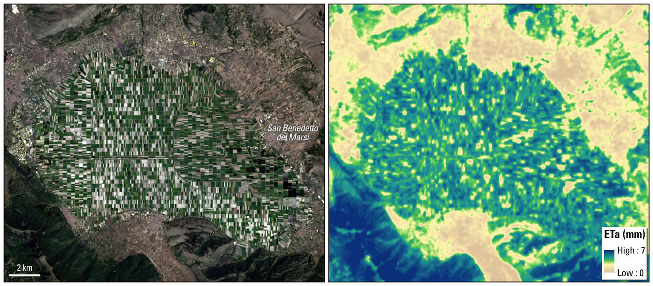
Landsat Collection 2 Level-2 Provisional Aquatic Reflectance (AR) and Level-3 Provisional Actual Evapotranspiration (ETa) science products are now available. Several improvements were made in Collection 2 Provisional AR and ETa, including the addition of Landsat 9. Details on improvements, along with technical details about Collection 2 Provisional AR and ETa are available on the Landsat Collection 2 Provisional Aquatic Reflectance Science Product and the Landsat Collection 2 Provisional Actual Evapotranspiration Science Product webpages. To access Landsat Collection 2 Provisional AR and ETa products submit a request using ESPA.
Example of the Landsat Collection 2 Provisional Evapotranspiration science product for agricultural fields on the Fucino plain near San Benedetto dei Marsi, Italy. Left: Landsat 9 Collection 2 Natural Color Surface Reflectance Image. Right: Landsat 9 Collection 2 Actual Evapotranspiration Image.
Karen St. Germain, NASA’s director of Earth Science Division, presented the 2020 Pecora Group Award on October 26, 2022, to the Landsat 5 Flight Operations Team, with Steve Covington accepting on behalf of the team.
The Pecora 22 Conference convened October 23–28 in Denver, Colorado. This year’s theme was “Opening the Aperture to Innovation: Expanding Our Collective Understanding of a Changing Earth” and celebrated the illustrious success of the Landsat mission and expansive archive.
Several staff from the USGS EROS Center presented at this year’s Pecora Conference. Presentations covered several aspects of Landsat from acquisition and processing through to end user applications. Several of the talks highlighted the Landsat science products, including the Collection 2 Fractional Snow Covered Area and Provisional Aquatic Reflectance science products. These science products ensure continuity to the Landsat record, allowing users to access large datasets with a consistent, quality product.
This year’s Pecora Conference honored several people and groups with the William T. Pecora Award. The ceremony was held on Wednesday, October 26, and honored the past three years’ recipients. This annual award, since 1974, is presented in the memory of Dr. William T. Pecora, former USGS Director and Department of the Interior Undersecretary. It is given to individuals and teams with outstanding achievements and contributions to remote sensing and Earth observations. For a complete list of all winners, please visit: https://www.usgs.gov/programs/national-land-imaging-program/william-t-pecora-award-recipients.
The Landsat Science Team met August 9–11, 2022, at the USGS EROS Center in Sioux Falls, South Dakota. During this meeting, updates on all active Landsat missions were presented, along with discussions about science and application advancements and accomplishments, processing objectives, and calibration statuses. Landsat science initiatives were also topics included during this meeting, including data harmonization with other Earth observing mission sensors. A special highlight of the week was witnessing the formal transition of the Landsat 9 operations from NASA to the USGS.
The Landsat Science Team is integral to the advancement of the Landsat Program. They provide scientific and technical evaluations on subjects of significance to the user community. This ensures the continued success of the Landsat Program within the partnership of the USGS and NASA. Visit the Landsat website for more information and to view Landsat Science Team presentations.
This picture shows the in-person attendees of the Landsat Science Team meeting August 9 - 11, 2022, which was held at the USGS Earth Resources Observation and Science Center, in Sioux Falls, South Dakota. Visit the Landsat Science Teams webpage for more information about the Landsat Science Team.
Stemming from the 2008 open data policy, several innovations in data use have created new niches far exceeding earlier expectations of the Landsat sensors and archive. A new interactive tool was created to highlight articles and publications featuring Landsat data. With this tool, users can navigate Landsat articles by location or interest. Please follow #HowDoYouLandsat or #HDYL on USGS Landsat social media pages for recently highlighted publications. This Landsat Update highlights a publication in the tool.
Ho, J.C., Michalak, A.M. & Pahlevan, N. Widespread global increase in intense lake phytoplankton blooms since the 1980s. Nature574, 667–670 (2019). https://doi.org/10.1038/s41586-019-1648-7
Using three decades of Landsat 5 data, the researchers of this article investigated long-term trends of near-surface phytoplankton blooms on large global freshwater lakes. Phytoplankton affects public health and ecosystems, and harmful effects are increasing and intensifying causing economic losses of more than US$4 billion annually.
Landsat Global Archive Consolidation - In this episode, we learn about the process that has gradually added millions of earlier Landsat scenes to the 50-year archive.
Landsat 50 Lookback - In this episode, we look back at how past guests viewed the value of Landsat satellites and their 50-year history.
Tour of the EROS Radome - In this episode, we take a tour of a crucial component of the Landsat data acquisition process at EROS: the radome that houses the 10-meter antenna for downlinking data to be placed in the archive.
Storymaps are an interactive way to learn more about Landsat using images, maps, videos, and weblinks. Take the opportunity to learn something new with the Storymaps linked below.
Eyes on Earth Episode 81 - Tour of the EROS Radome
The Landsat satellites have been collecting Earth imagery for more than 50 years. A key piece of equipment that moves the data from the spacecraft to the archive so researchers can use it is the antenna at the EROS Center. The antenna and its radome have a fascinating history of their own that adds to the overall Landsat story.
The Landsat satellites have been collecting Earth imagery for more than 50 years. A key piece of equipment that moves the data from the spacecraft to the archive so researchers can use it is the antenna at the EROS Center. The antenna and its radome have a fascinating history of their own that adds to the overall Landsat story.
Eyes on Earth Episode 79 – Landsat Global Archive Consolidation
The Landsat archive at EROS contains an unparalleled 50 years of Earth observation data. But with earlier technologies, some Landsat scenes were collected and stored only by international ground receiving stations rather than in the central archive at EROS.
The Landsat archive at EROS contains an unparalleled 50 years of Earth observation data. But with earlier technologies, some Landsat scenes were collected and stored only by international ground receiving stations rather than in the central archive at EROS.
Government officials and scientists had high hopes for Landsat when the first experimental satellite launched July 23, 1972. Those hopes were soon realized when imagery came back depicting features never before seen. Since then, an archive of imagery surpassing 10 million scenes has amassed at EROS, collected from eight different Landsat satellites.
Government officials and scientists had high hopes for Landsat when the first experimental satellite launched July 23, 1972. Those hopes were soon realized when imagery came back depicting features never before seen. Since then, an archive of imagery surpassing 10 million scenes has amassed at EROS, collected from eight different Landsat satellites.
During the early post-launch phase of the Landsat 9 mission, the Landsat 8 and 9 mission teams conducted a successful under-fly of Landsat 8 by Landsat 9, allowing for the near-simultaneous data collection of common Earth targets by the on-board sensors for cross-calibration. This effort, coordinated by the Landsat Calibration and Validation team, required contributions from various...
Authors
Edward Kaita, Brian Markham, Md Obaidul Haque, Donald Dichmann, Aaron Gerace, Lawrence Leigh, Susan Good, Michael Schmidt, Christopher J. Crawford
The Landsat program has a long history of providing remotely sensed data to the user community. This history is being extended with the addition of the Landsat 9 satellite, which closely mimics the Landsat 8 satellite and its instruments. These satellites contain two instruments, the Operational Land Imager (OLI) and the Thermal Infrared Sensor (TIRS). OLI is a push-broom sensor that...
Authors
Michael J. Choate, Rajagopalan Rengarajan, James C. Storey, Mark Lubke
Over the course of fifty years, eight Landsat satellites have observed the Earth's surface. This storymap collection allows users to view each satellite's heritage from Landsat 1 through Landsat 9 (Landsat 6 did not achieve orbit). See first light images, significant events, and unique science for each satellite.
This story contains examples of regional and global projects that utilize Landsat data to assist policymakers and land managers in making informed decisions about our environment and Earth’s natural resources.
Landsat 5 Flight Operations Team Wins Pecora Award
Landsat 5, already honored by the Guinness Book of World Records as the Longest Operating Earth Observation Satellite, received another award at the...
Landsat Science Team Meets, Celebrates Landsat 9 Transition
The 2018-2023 Landsat Science Team met for their summer meeting at the USGS Earth Resources Observation and Science (EROS) Center in Sioux Falls, S.D...
Event Celebrates a Satellite’s New Phase and Landsat’s Legacy
On a pleasant, breezy summer day, a crowd gathered under a white event tent on the USGS Earth Resources Observation and Science (EROS) Center’s lawn...
Landsat Collection 2 marks the second major reprocessing event of the USGS Landsat archive. Continuing the tiered collection management structure implemented in Landsat Collection 1, Landsat Collection 2 introduces several advancements in data processing, algorithm development, as well as data access and distribution capabilities, including: Improved per-pixel geodetic accuracy by incorporating...
Landsat Collection 2 marks the second major reprocessing event of the USGS Landsat archive. Continuing the tiered collection management structure implemented in Landsat Collection 1, Landsat Collection 2 introduces several advancements in data processing, algorithm development, as well as data access and distribution capabilities, including: Improved per-pixel geodetic accuracy by incorporating...
The naming convention for Landsat Collection 2 Level-1 products remains the same as in Collection 1. While most of Landsat Collection 2 scenes are produced to both Surface Reflectance (SR) and Surface Temperature (ST), a small number of scenes cannot be processed to ST due to missing auxiliary data. The naming convention of Landsat Collection 2 Level-2 products indicates the data included for each...
What is the naming convention for Landsat Collection 2 Level-1 and Level-2 scenes?
The naming convention for Landsat Collection 2 Level-1 products remains the same as in Collection 1. While most of Landsat Collection 2 scenes are produced to both Surface Reflectance (SR) and Surface Temperature (ST), a small number of scenes cannot be processed to ST due to missing auxiliary data. The naming convention of Landsat Collection 2 Level-2 products indicates the data included for each...
Landsat Collection 2 Level-2 Surface Reflectance and Surface Temperature science products are scene-based, produced within the standard processing system, and available to download directly from EarthExplorer. Collection 2 Level-2 products are available for Landsat 4-5 TM, Landsat 7 ETM+, and Landsat 8-9 OLI/TIRS data acquired from 1982 to present. Landsat MSS 1-5 data are not currently available...
How do Landsat Collection 2 Level-2 products compare with products from Collection 1?
Landsat Collection 2 Level-2 Surface Reflectance and Surface Temperature science products are scene-based, produced within the standard processing system, and available to download directly from EarthExplorer. Collection 2 Level-2 products are available for Landsat 4-5 TM, Landsat 7 ETM+, and Landsat 8-9 OLI/TIRS data acquired from 1982 to present. Landsat MSS 1-5 data are not currently available...
The fill values and scale factors of Landsat Collection 2 Level-2 products were updated to be consistent with that of Landsat Collection 2 Level-1 data, while using the unsigned integer data type more efficiently. As shown in the table below, the fill value of the Surface Reflectance and Surface Temperature bands were changed from “-9999” in Collection 1, to “0” in Collection 2 to be consistent...
Why are the fill values and scaling factors of Landsat Collection 2 Level-2 products different from those products in Collection 1?
The fill values and scale factors of Landsat Collection 2 Level-2 products were updated to be consistent with that of Landsat Collection 2 Level-1 data, while using the unsigned integer data type more efficiently. As shown in the table below, the fill value of the Surface Reflectance and Surface Temperature bands were changed from “-9999” in Collection 1, to “0” in Collection 2 to be consistent...
Landsat Collection 2 Level-1 and Level-2 products can be searched using EarthExplorer, the primary portal used to search all data held in the USGS EROS archives. Landsat Collection 2 products are processed and stored in the USGS Cloud Hosting Solution (CHS) environment; downloads are managed through EarthExplorer. The USGS Landsat no-cost open data policy remains intact since its inception in 2008...
How do I search and download Landsat Collection 2 data products?
Landsat Collection 2 Level-1 and Level-2 products can be searched using EarthExplorer, the primary portal used to search all data held in the USGS EROS archives. Landsat Collection 2 products are processed and stored in the USGS Cloud Hosting Solution (CHS) environment; downloads are managed through EarthExplorer. The USGS Landsat no-cost open data policy remains intact since its inception in 2008...