
Topobathymetric digital elevation model of the Kootenai River, Idaho. Image was created by Cindy Thatcher.
Images
Images intro.
Filter Total Items: 439

Topobathymetric digital elevation model of the Kootenai River, Idaho.
Topobathymetric digital elevation model of the Kootenai River, Idaho. Image was created by Cindy Thatcher.

USGS Supercomputer Usage
This graph shows the number of compute hours on the USGS Supercomputers for Fiscal Years 2019-2023.
This graph shows the number of compute hours on the USGS Supercomputers for Fiscal Years 2019-2023.

Yellowstone Turkey.png
Background: USGS Photo of Porkchop Geyer in Yellowstone. Foreground: A cartoon turkey wearing an astronaut helmet looks sheepishly at Porkchop Geyser erupting nearby. Cartoon images of common Thanksgiving side dishes are also placed around the turkey (in this case, a gravy boat and an ear of corn).
Background: USGS Photo of Porkchop Geyer in Yellowstone. Foreground: A cartoon turkey wearing an astronaut helmet looks sheepishly at Porkchop Geyser erupting nearby. Cartoon images of common Thanksgiving side dishes are also placed around the turkey (in this case, a gravy boat and an ear of corn).

Closeup View of Model of the Unisphere (Erosphere) Project on Display at Museum
A model of the Unisphere project on display at the Old Courthouse Museum in Sioux Falls, South Dakota. The concept of the project, originally called “Erosphere,” included a science center, farm of the future, visitor center, and space for scientific conventions.
A model of the Unisphere project on display at the Old Courthouse Museum in Sioux Falls, South Dakota. The concept of the project, originally called “Erosphere,” included a science center, farm of the future, visitor center, and space for scientific conventions.

Illustration of Terrestrial Planet Formation
A simplified view of the classical model for terrestrial planet formation (not to scale). From top to bottom: The central star is surrounded by nebular gas and dust where early solids form.
A simplified view of the classical model for terrestrial planet formation (not to scale). From top to bottom: The central star is surrounded by nebular gas and dust where early solids form.

FY23 Status of 3DEP Quality Data
This map of the United States and its territories shows the areal extent and quality level of planned, in-progress, and existing publicly available lidar (IfSAR in Alaska) data identified by the United States Interagency Elevation Inventory (USIEI) that meet 3DEP base level specification planned to be under award by September 30, 2023. 3DEP base level spec
This map of the United States and its territories shows the areal extent and quality level of planned, in-progress, and existing publicly available lidar (IfSAR in Alaska) data identified by the United States Interagency Elevation Inventory (USIEI) that meet 3DEP base level specification planned to be under award by September 30, 2023. 3DEP base level spec

Landsat 9 image of the White Mountain National Forest, New Hampshire
Natural color image of the White Mountain National Forest, New Hampshire, as seen by Landsat 9 on October 4th, 2023.
WRS-2 Path 013 Row 029.
Bands 4,3,2
Landsat Scene ID LC09_L2SP_013029_20231004_20231005_02_T1
Natural color image of the White Mountain National Forest, New Hampshire, as seen by Landsat 9 on October 4th, 2023.
WRS-2 Path 013 Row 029.
Bands 4,3,2
Landsat Scene ID LC09_L2SP_013029_20231004_20231005_02_T1

The Landsat Flight Operations Team Monitoring Pre-Burn Contact
This image shows the Landsat flight Operations Team monitoring a pre burn contact, ensuring the satellite is ready for the maneuver.
This image shows the Landsat flight Operations Team monitoring a pre burn contact, ensuring the satellite is ready for the maneuver.

3DEP Quality Data by Collection Year
This map of the United States and its territories shows geographic extent of planned, existing, and in-progress 3DEP data acquisition projects by year.
This map of the United States and its territories shows geographic extent of planned, existing, and in-progress 3DEP data acquisition projects by year.

FY23 Status of 3DHP Quality Data
This map of the United States and its territories shows geographic extent of the first-ever nationally consistent hydrography data acquired from high-resolution 3D Elevation Program (3DEP) data. FY23 projects are the result of ongoing Federal coordination via the 3DHP Working Group and the Alaska Mapping Initiative.
This map of the United States and its territories shows geographic extent of the first-ever nationally consistent hydrography data acquired from high-resolution 3D Elevation Program (3DEP) data. FY23 projects are the result of ongoing Federal coordination via the 3DHP Working Group and the Alaska Mapping Initiative.

FY23 Status of 3DHP Quality Data in Alaska
This map of Alaska shows geographic extent of the first-ever nationally consistent hydrography data acquired from high-resolution 3D Elevation Program (3DEP) data. FY23 projects are the result of ongoing Federal coordination via the 3DHP Working Group and the Alaska Mapping Initiative.
Explanation
This map of Alaska shows geographic extent of the first-ever nationally consistent hydrography data acquired from high-resolution 3D Elevation Program (3DEP) data. FY23 projects are the result of ongoing Federal coordination via the 3DHP Working Group and the Alaska Mapping Initiative.
Explanation

3D Hydrography Program FY23 Partnerships in Alaska
This map of Alaska shows geographic extent of the first-ever nationally consistent hydrography data acquired from high-resolution 3D Elevation Program (3DEP) data. FY23 projects are the result of ongoing Federal coordination via the 3DHP Working Group and the Alaska Mapping Initiative.
Explanation
This map of Alaska shows geographic extent of the first-ever nationally consistent hydrography data acquired from high-resolution 3D Elevation Program (3DEP) data. FY23 projects are the result of ongoing Federal coordination via the 3DHP Working Group and the Alaska Mapping Initiative.
Explanation

3DEP Quality Data by Collection Year Animated GIF
This animated GIF is a map of the United States and its territories shows geographic extent of planned, existing, and in-progress 3DEP data acquisition projects by year.
This animated GIF is a map of the United States and its territories shows geographic extent of planned, existing, and in-progress 3DEP data acquisition projects by year.

3D Hydrography Program FY23 Partnerships
This map of the United States and its territories shows geographic extent of the first-ever nationally consistent hydrography data acquired from high-resolution 3D Elevation Program (3DEP) data. FY23 projects are the result of ongoing Federal coordination via the 3DHP Working Group and the Alaska Mapping Initiative.
This map of the United States and its territories shows geographic extent of the first-ever nationally consistent hydrography data acquired from high-resolution 3D Elevation Program (3DEP) data. FY23 projects are the result of ongoing Federal coordination via the 3DHP Working Group and the Alaska Mapping Initiative.

EROS Radome in the Fall
Fall foliage surrounds the 60-foot radome at the Earth Resources Observation and Science (EROS) Center in Sioux Falls, South Dakota. The radome protects the 10-meter Landsat antenna.
Fall foliage surrounds the 60-foot radome at the Earth Resources Observation and Science (EROS) Center in Sioux Falls, South Dakota. The radome protects the 10-meter Landsat antenna.
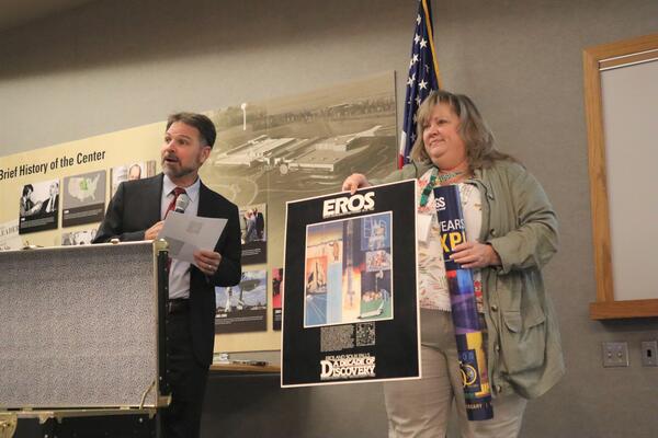
USGS EROS Center Director Pete Doucette and Branch Chief for New Missions Kristi Kline
While USGS Earth Resources Observation and Science (EROS) Center Director Pete Doucette tells the audience a little about the 10th anniversary festivities at EROS during the August 18, 2023, rededication ceremony, EROS Branch Chief for New Missions Kristi Kline holds up a 10th anniversary poster from the time capsule and prepares to add a 50
While USGS Earth Resources Observation and Science (EROS) Center Director Pete Doucette tells the audience a little about the 10th anniversary festivities at EROS during the August 18, 2023, rededication ceremony, EROS Branch Chief for New Missions Kristi Kline holds up a 10th anniversary poster from the time capsule and prepares to add a 50

EROS 50th Anniversary Reception
The USGS Earth Resources Observation and Science (EROS) Center reception area fills with people for a 50th anniversary event August 19, 2023.
The USGS Earth Resources Observation and Science (EROS) Center reception area fills with people for a 50th anniversary event August 19, 2023.

Sioux Falls, South Dakota, Puzzle
Large floor puzzles of Sioux Falls and Denver help entertain guests during the 50th anniversary event August 19, 2023.
Large floor puzzles of Sioux Falls and Denver help entertain guests during the 50th anniversary event August 19, 2023.

Public Tour at USGS EROS
Laura Nemec, a contractor at the USGS Earth Resources Observation and Science (EROS) Center, guides a tour group at the 50th anniversary event August 19, 2023. In the background is a display showing the size of the Landsat 9 satellite.
Laura Nemec, a contractor at the USGS Earth Resources Observation and Science (EROS) Center, guides a tour group at the 50th anniversary event August 19, 2023. In the background is a display showing the size of the Landsat 9 satellite.

USGS Director David Applegate and USGS EROS Center Director Pete Doucette plant a tree
On August 19, 2023, USGS Director David Applegate and USGS Earth Resources Observation and Science (EROS) Center Director Pete Doucette use golden shovels that have been used at other EROS dedication events to help dedicate a red oak tree, a long-living species, that will be planted at EROS as a symbolic gesture to its future beyond 50 years.
On August 19, 2023, USGS Director David Applegate and USGS Earth Resources Observation and Science (EROS) Center Director Pete Doucette use golden shovels that have been used at other EROS dedication events to help dedicate a red oak tree, a long-living species, that will be planted at EROS as a symbolic gesture to its future beyond 50 years.

Hovenweep High Performance Computing System
The Hovenweep High Performance Computing (HPC) system located at the USGS Earth Resources Observation and Science (EROS) Center in Sioux Falls, SD.
The Hovenweep High Performance Computing (HPC) system located at the USGS Earth Resources Observation and Science (EROS) Center in Sioux Falls, SD.