
Preacher, a Boykin spaniel, holds a harvest duck in his mouth. He belongs to longtime waterfowl hunter Tyler Coleman. The duck has bird bands on its legs.
Images
See our science through the images below.
Filter Total Items: 3543

Hunting dog with a duck in its mouth
Preacher, a Boykin spaniel, holds a harvest duck in his mouth. He belongs to longtime waterfowl hunter Tyler Coleman. The duck has bird bands on its legs.

Holding Banded Ducks
Hunter Tyler Coleman holds two harvested ducks that have been banded. Coleman believes all hunter should report bands.
Hunter Tyler Coleman holds two harvested ducks that have been banded. Coleman believes all hunter should report bands.

Ghost Forest II - Goose Creek
A ghost forest stands in Goose Creek State Park in North Carolina. This is an example of a freshwater forested wetland that is transitioning to open water.
A ghost forest stands in Goose Creek State Park in North Carolina. This is an example of a freshwater forested wetland that is transitioning to open water.

Scientist, Paul Hershberger, at the Marrowstone Marine Field Station in Washington
Scientist, Paul Hershberger, at the Marrowstone Marine Field Station in WashingtonThis is a photo of Paul Hershberger at Marrowstone Marine Field Station Lab. Dr. Hershberger studies diseases in fish.
Scientist, Paul Hershberger, at the Marrowstone Marine Field Station in Washington
Scientist, Paul Hershberger, at the Marrowstone Marine Field Station in WashingtonThis is a photo of Paul Hershberger at Marrowstone Marine Field Station Lab. Dr. Hershberger studies diseases in fish.

Mallard
Mallard is a large dabbling duck, length 15-16 inches, with a wingspan up to 36 inches.
Mallard is a large dabbling duck, length 15-16 inches, with a wingspan up to 36 inches.

White-tailed deer
White-tailed deer is native to North America and live in most states except Alaska, California, Nevada, and Utah (source: USFS).
White-tailed deer is native to North America and live in most states except Alaska, California, Nevada, and Utah (source: USFS).

Oak forest in Waterloo State Recreation area in southern Michigan
Oak forest in Waterloo State Recreation area in southern MichiganWaterloo State Recreation area in southern MI. Like the Huron National Forest near Cadillac, Michigan, this site had around 68% cover of northern red oak and red maple was the largest associate.
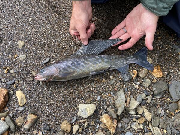
Arctic Grayling (Thymallus arctus) caught in the Nakolikuruk River near an orange tributary, Noatak National Preserve, Alaska
Arctic Grayling (Thymallus arctus) caught in the Nakolikuruk River near an orange tributary, Noatak National Preserve, AlaskaOrange streams are increasingly common in the Brooks Range of northern Alaska. The orange stream color reflects oxidized iron, but also often indicates elevated heavy metal concentrations. Our ongoing study aims to document these occurrences and the timing of their onset.
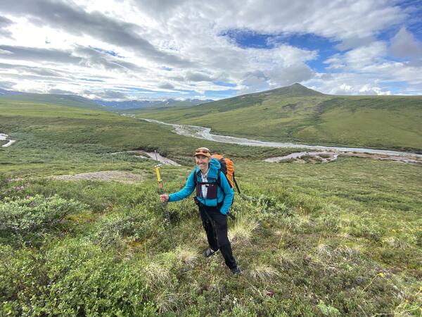
Surveying for "rusting rivers" in the Nakolikurok Creek watershed, Noatak National Preserve, Alaska
Surveying for "rusting rivers" in the Nakolikurok Creek watershed, Noatak National Preserve, AlaskaOrange streams are increasingly common in the Brooks Range of northern Alaska. The orange stream color reflects oxidized iron, but also often indicates elevated heavy metal concentrations. Our ongoing study aims to document these occurrences and the timing of their onset.

Researchers following orange staining up the braidplain of the Nakolikurok Creek
Researchers following orange staining up the braidplain of the Nakolikurok CreekOrange streams are increasingly common in the Brooks Range of northern Alaska. The orange stream color reflects oxidized iron, but also often indicates elevated heavy metal concentrations. Our ongoing study aims to document these occurrences and the timing of their onset.
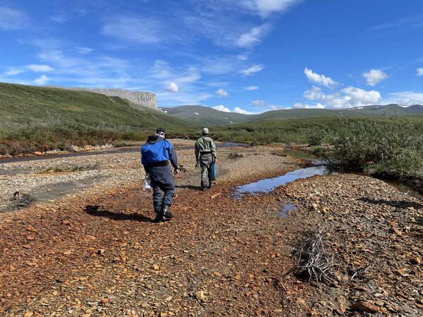
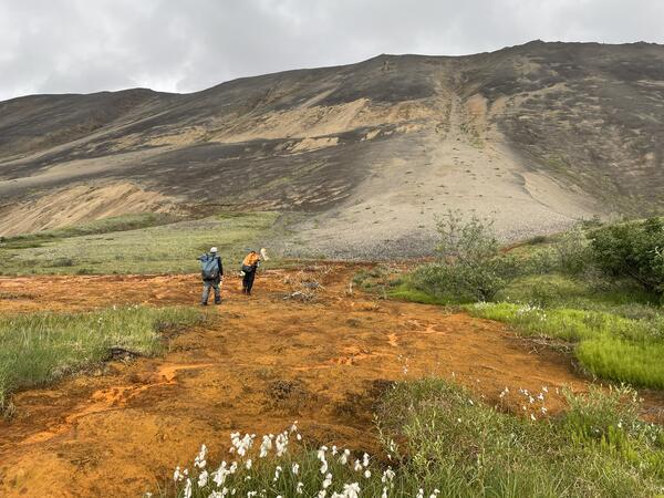
Researchers walking to a site to sample rusting in the Nakolikurok Creek Watershed
Researchers walking to a site to sample rusting in the Nakolikurok Creek WatershedOrange streams are increasingly common in the Brooks Range of northern Alaska. The orange stream color reflects oxidized iron, but also often indicates elevated heavy metal concentrations. Our ongoing study aims to document these occurrences and the timing of their onset.
A seep emanates from a hillslope in the Nakolikurok Creek Watershed, blackening vegetation and staining the streambanks orange
A seep emanates from a hillslope in the Nakolikurok Creek Watershed, blackening vegetation and staining the streambanks orangeOrange streams are increasingly common in the Brooks Range of northern Alaska. The orange stream color reflects oxidized iron, but also often indicates elevated heavy metal concentrations. Our ongoing study aims to document these occurrences and the timing of their onset.

Bat box
A bat box, photographed as part of NABat fieldwork in 2024.
A bat box, photographed as part of NABat fieldwork in 2024.

Removing a bat from a mist net
Andrea Schuhmann removes a bat from a mist net during NABat Fieldwork in 2024.
Andrea Schuhmann removes a bat from a mist net during NABat Fieldwork in 2024.
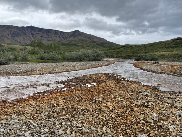
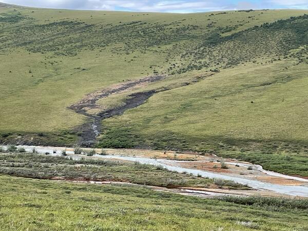
Orange staining in the braidplain of the Nakolikurok Creek
Orange staining in the braidplain of the Nakolikurok CreekOrange streams are increasingly common in the Brooks Range of northern Alaska. The orange stream color reflects oxidized iron, but also often indicates elevated heavy metal concentrations. Our ongoing study aims to document these occurrences and the timing of their onset.
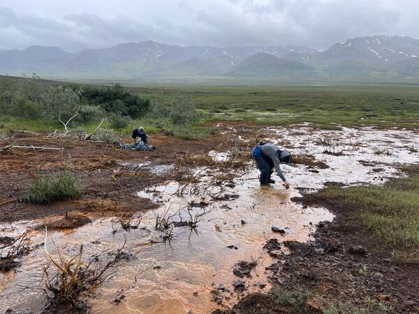
Two scientists sample the orange water of a seep in the Kelly River Watershed, Alaska
Two scientists sample the orange water of a seep in the Kelly River Watershed, AlaskaOrange streams are increasingly common in the Brooks Range of northern Alaska. The orange stream color reflects oxidized iron, but also often indicates elevated heavy metal concentrations. Our ongoing study aims to document these occurrences and the timing of their onset.
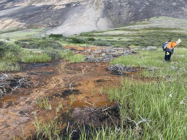
A scientist walks uphill towards the source of an orange seep
A scientist walks uphill towards the source of an orange seepOrange streams are increasingly common in the Brooks Range of northern Alaska. The orange stream color reflects oxidized iron, but also often indicates elevated heavy metal concentrations. Our ongoing study aims to document these occurrences and the timing of their onset.
Two scientists investigating the source of an orange seep
Two scientists investigating the source of an orange seepOrange streams are increasingly common in the Brooks Range of northern Alaska. The orange stream color reflects oxidized iron, but also often indicates elevated heavy metal concentrations. Our ongoing study aims to document these occurrences and the timing of their onset.
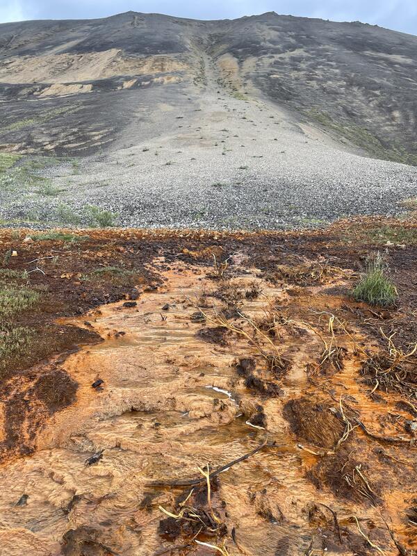
Orange staining and blackened vegetation where a seep emerges from a debris fan
Orange staining and blackened vegetation where a seep emerges from a debris fanOrange streams are increasingly common in the Brooks Range of northern Alaska. The orange stream color reflects oxidized iron, but also often indicates elevated heavy metal concentrations. Our ongoing study aims to document these occurrences and the timing of their onset.

Field sampling in Montana
A landscape of sagebrush (Artemisia tridentada) and yellow sweet clover (Melilotus officinalis) on the Charles M. Russell National Wildlife Refuge in Montana.
A landscape of sagebrush (Artemisia tridentada) and yellow sweet clover (Melilotus officinalis) on the Charles M. Russell National Wildlife Refuge in Montana.

PFOS in the presence of sulfate-reducing bacteria
PFOS removal occurred as sulfate-reducing bacteria increased in soil experiments with a dehalogenating culture. Graphic Credits: Denise Akob
PFOS removal occurred as sulfate-reducing bacteria increased in soil experiments with a dehalogenating culture. Graphic Credits: Denise Akob