



These are two USGS Western Fisheries Research Center scientists, Carl Ostberg and Jeff Duda (from left to right), sitting on a fallen tree in Skagit, WA. These scientists study critical fish, like salmon, in the Ross Dam reservoir and tributaries.
Images
See our science through the images below.
Filter Total Items: 3592
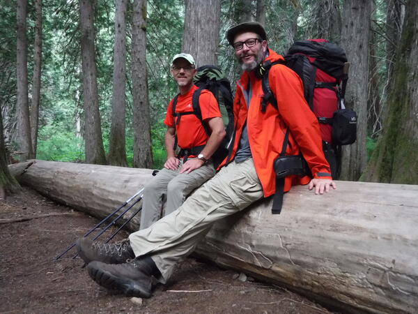
USGS Fisheries Scientists in Skagit County, WA
These are two USGS Western Fisheries Research Center scientists, Carl Ostberg and Jeff Duda (from left to right), sitting on a fallen tree in Skagit, WA. These scientists study critical fish, like salmon, in the Ross Dam reservoir and tributaries.
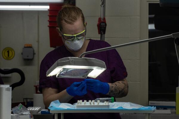
Scientists investigate pathogens in salamanders
A USGS scientist examines salamanders as part of a study to investigate for potential pathogens.
A USGS scientist examines salamanders as part of a study to investigate for potential pathogens.
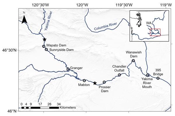
Lower Yakima River Study Map
This is a map of the lower Yakima River showing locations where acoustic telemetry receivers were deployed (open circles) to detect tagged fish that were released at two sites (stars). This was part of the study titled, "Survival implications of diversion entrainment for out-migrating juvenile Chinook Salmon and steelhead.
This is a map of the lower Yakima River showing locations where acoustic telemetry receivers were deployed (open circles) to detect tagged fish that were released at two sites (stars). This was part of the study titled, "Survival implications of diversion entrainment for out-migrating juvenile Chinook Salmon and steelhead.
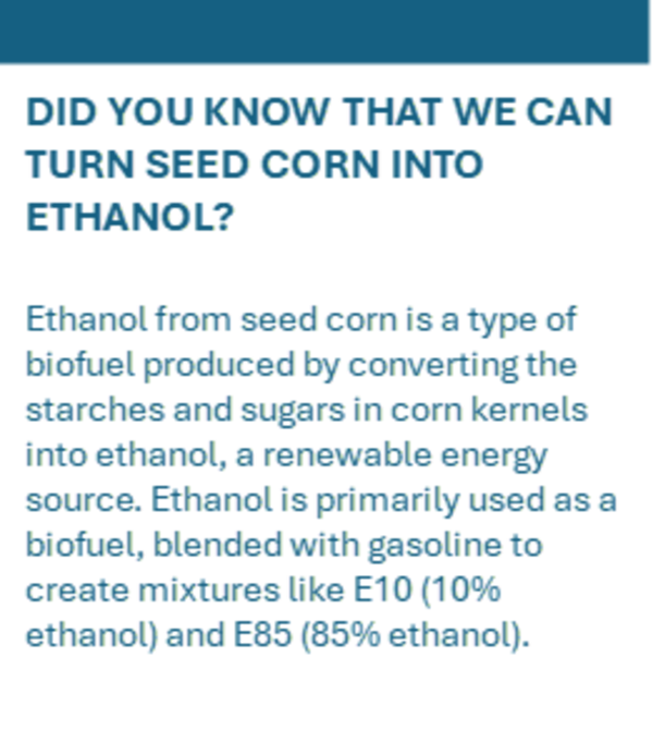
Turning seed corn into ethanol
Ethanol from seed corn is a type of biofuel produced by converting the starches and sugars in corn kernels into ethanol, a renewable energy source.
Ethanol from seed corn is a type of biofuel produced by converting the starches and sugars in corn kernels into ethanol, a renewable energy source.
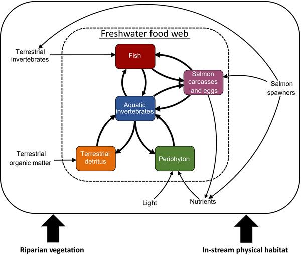
Simplified river food web
Conceptual diagram of the Aquatic Trophic Productivity Model, illustrating (1) biomass stocks of organisms and organic matter (rectangular boxes), (2) consumer–resource interactions that link biomass stocks, (3) inputs of energy, nutrients, and organic matter from outside the system (salmon spawners, light, nutrients, terrestrial organic matter and terrestrial inver
Conceptual diagram of the Aquatic Trophic Productivity Model, illustrating (1) biomass stocks of organisms and organic matter (rectangular boxes), (2) consumer–resource interactions that link biomass stocks, (3) inputs of energy, nutrients, and organic matter from outside the system (salmon spawners, light, nutrients, terrestrial organic matter and terrestrial inver
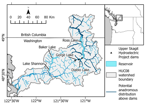
Map of Skagit
Map of the study system. The potential anadromous distribution above the dams indicated is based only on potential physical access to those stream segments (i.e., no migration barriers). Further details and habitat quality results from intrinsic potential modeling can be found in Duda and Hardiman.
Map of the study system. The potential anadromous distribution above the dams indicated is based only on potential physical access to those stream segments (i.e., no migration barriers). Further details and habitat quality results from intrinsic potential modeling can be found in Duda and Hardiman.
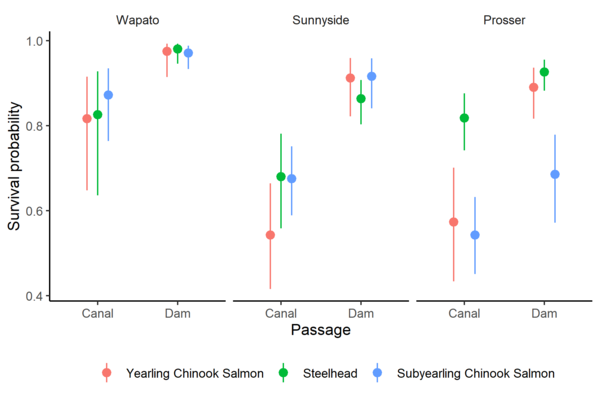
Survival Probabilities of Fish Through Canals Versus Dams
Survival Probabilities of Fish Through Canals Versus DamsSurvival probability estimates and 95% confidence intervals for yearling Chinook Salmon, juvenile steelhead, and subyearling Chinook Salmon at three diversion dams on the Yakima River, Washington.
Survival Probabilities of Fish Through Canals Versus Dams
Survival Probabilities of Fish Through Canals Versus DamsSurvival probability estimates and 95% confidence intervals for yearling Chinook Salmon, juvenile steelhead, and subyearling Chinook Salmon at three diversion dams on the Yakima River, Washington.
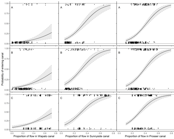
Nine Panel Plot of Fish Passage Entrainment vs Canal Flow
Nine Panel Plot of Fish Passage Entrainment vs Canal FlowEstimated relationship between entrainment probability and proportion of river flow entering canals at Wapato Dam, Sunnyside Dam, and Prosser Dam on the Yakima River, Washington. The relationships are shown at the mean total river flow for (A) yearling Chinook Salmon, (B) juvenile steelhead, and (C) subyearling Chinook Salmon.
Nine Panel Plot of Fish Passage Entrainment vs Canal Flow
Nine Panel Plot of Fish Passage Entrainment vs Canal FlowEstimated relationship between entrainment probability and proportion of river flow entering canals at Wapato Dam, Sunnyside Dam, and Prosser Dam on the Yakima River, Washington. The relationships are shown at the mean total river flow for (A) yearling Chinook Salmon, (B) juvenile steelhead, and (C) subyearling Chinook Salmon.
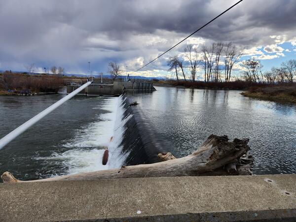
Dam in the lower Yakima River
This is a photo of a dam in the lower Yakima River. Efforts to ameliorate the negative effects of diversion dams on aquatic species of concern are important in rivers where water withdrawal supports agricultural economies, and they are likely to become increasingly important with impending climate change.
This is a photo of a dam in the lower Yakima River. Efforts to ameliorate the negative effects of diversion dams on aquatic species of concern are important in rivers where water withdrawal supports agricultural economies, and they are likely to become increasingly important with impending climate change.
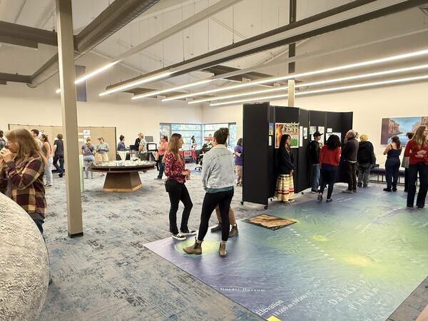
FALA USGS art show Sept 2025.jpg
Art of Inquiry show hosted at USGS on 22 September, 2025 as part of Flagstaff Festival of Science and in collaboration with Flagstaff Arts and Leadership Academy
Art of Inquiry show hosted at USGS on 22 September, 2025 as part of Flagstaff Festival of Science and in collaboration with Flagstaff Arts and Leadership Academy
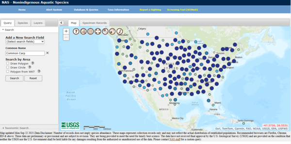
NAS Database
This is a screen grab of the Nonindigenous Aquatic Species Database. This database is used to track the spread of invasive aquatic species across the United States landscape.
This is a screen grab of the Nonindigenous Aquatic Species Database. This database is used to track the spread of invasive aquatic species across the United States landscape.
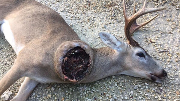
New World Screwworm On an Open Wound
New World Screwworm is a fly (Cochliomyia hominivorax) that lays eggs in open wounds of warm-blooded animals. Once hatched, the larvae (maggots) consume the living tissues at the edge of the wound, leading to severe illness and death if left untreated.
New World Screwworm is a fly (Cochliomyia hominivorax) that lays eggs in open wounds of warm-blooded animals. Once hatched, the larvae (maggots) consume the living tissues at the edge of the wound, leading to severe illness and death if left untreated.
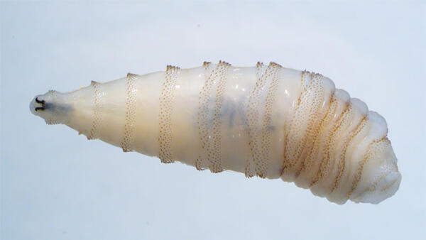
New World Screwworm larvae
New World Screwworm is a fly (Cochliomyia hominivorax) that lays eggs in open wounds of warm-blooded animals. Once hatched, the larvae (maggots) consume the living tissues at the edge of the wound, leading to severe illness and death if left untreated.
New World Screwworm is a fly (Cochliomyia hominivorax) that lays eggs in open wounds of warm-blooded animals. Once hatched, the larvae (maggots) consume the living tissues at the edge of the wound, leading to severe illness and death if left untreated.
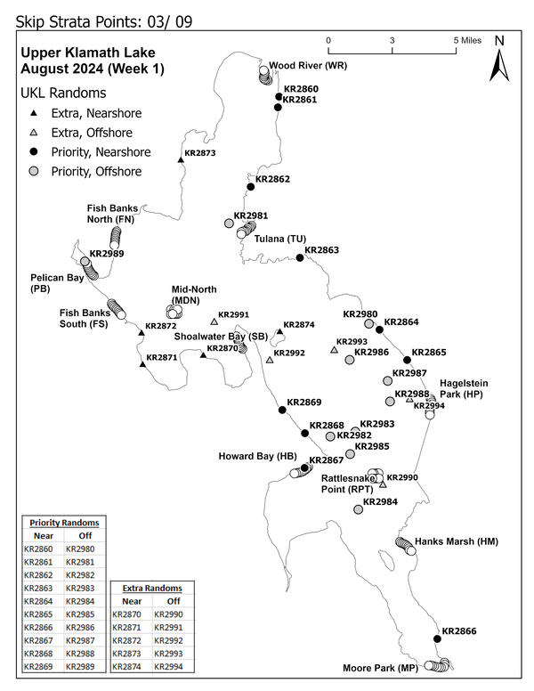
Sucker Nets on Upper Klamath Lake
This is a map of the nets on the Upper Klamath Lake in Oregon. The Western Fisheries Research Center carefully monitors juvenile Sucker populations for signs of population recovery and to better understand where they habitate.
This is a map of the nets on the Upper Klamath Lake in Oregon. The Western Fisheries Research Center carefully monitors juvenile Sucker populations for signs of population recovery and to better understand where they habitate.
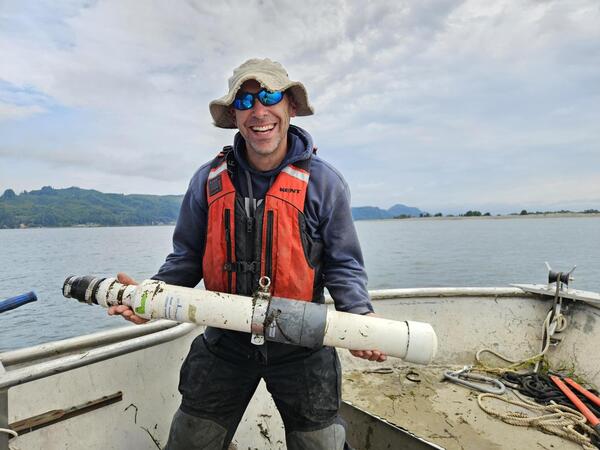
Scientist Holding a Telemetry Receiver for Tracking Fish
Scientist Holding a Telemetry Receiver for Tracking FishRyan Tomka retrieves an acoustic telemetry receiver from the lower Columbia River estuary. During the 2025 field season, researchers deployed acoustic telemetry equipment to track yearling Chinook salmon as they moved through both restored estuarine wetlands and the main Columbia River channel.
Scientist Holding a Telemetry Receiver for Tracking Fish
Scientist Holding a Telemetry Receiver for Tracking FishRyan Tomka retrieves an acoustic telemetry receiver from the lower Columbia River estuary. During the 2025 field season, researchers deployed acoustic telemetry equipment to track yearling Chinook salmon as they moved through both restored estuarine wetlands and the main Columbia River channel.
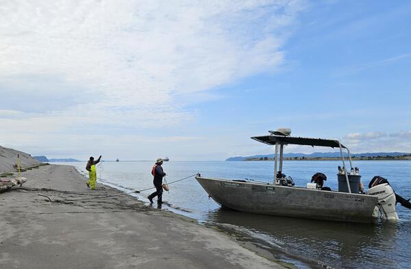
USGS Researchers Load Boat in Columbia River, OR
Chris Pullano and Ryan Tomka load acoustic telemetry receives on to boat in lower Columbia River estuary. Field work was recently completed for the first year of a study to better understand how young salmon use restored habitats in the Lower Columbia River Estuary.
Chris Pullano and Ryan Tomka load acoustic telemetry receives on to boat in lower Columbia River estuary. Field work was recently completed for the first year of a study to better understand how young salmon use restored habitats in the Lower Columbia River Estuary.
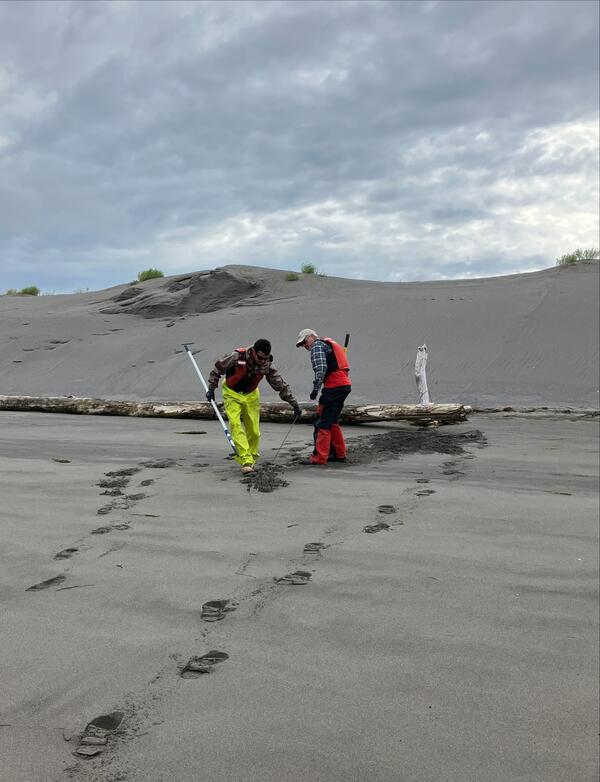
USGS Scientists Unearth Buried Cable Tethering a Telemetry Receiver to Shore in the Columbia River
USGS Scientists Unearth Buried Cable Tethering a Telemetry Receiver to Shore in the Columbia RiverChirs Pullano and Collin Smith unearth the buried cable tethering an acoustic receiver to shore in the lower Columbia River estuary. Shifting sands frequently bury equipment making it difficult to retrieve. During the 2025 field season, researchers deployed acoustic telemetry equipment to track yearling Chinook salmon as they moved through both restored e
USGS Scientists Unearth Buried Cable Tethering a Telemetry Receiver to Shore in the Columbia River
USGS Scientists Unearth Buried Cable Tethering a Telemetry Receiver to Shore in the Columbia RiverChirs Pullano and Collin Smith unearth the buried cable tethering an acoustic receiver to shore in the lower Columbia River estuary. Shifting sands frequently bury equipment making it difficult to retrieve. During the 2025 field season, researchers deployed acoustic telemetry equipment to track yearling Chinook salmon as they moved through both restored e
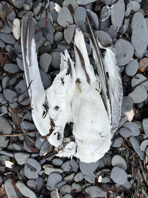
A dead Black-legged Kittiwake lies on the beach on Homer Spit in Kachemak Bay
A dead Black-legged Kittiwake lies on the beach on Homer Spit in Kachemak BayA die-off of primarily Black-legged Kittiwakes took place from July-September 2025 in Kachemak Bay and killed hundreds of birds as well as several species of marine mammals. There is not yet an identified cause of death.
A dead Black-legged Kittiwake lies on the beach on Homer Spit in Kachemak Bay
A dead Black-legged Kittiwake lies on the beach on Homer Spit in Kachemak BayA die-off of primarily Black-legged Kittiwakes took place from July-September 2025 in Kachemak Bay and killed hundreds of birds as well as several species of marine mammals. There is not yet an identified cause of death.
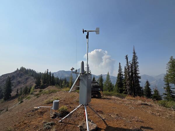
Incident Remote Automatic Weather Station (iRAWS) at the Okanogan–Wenatchee National Forest in Washington
Incident Remote Automatic Weather Station (iRAWS) at the Okanogan–Wenatchee National Forest in WashingtonAn Incident Remote Automatic Weather Station (iRAWS) is a portable, solar-powered weather station to support fire operations on the Lower Sugarloaf Fire, Okanogan-Wenatchee National Forest in Washington.
Incident Remote Automatic Weather Station (iRAWS) at the Okanogan–Wenatchee National Forest in Washington
Incident Remote Automatic Weather Station (iRAWS) at the Okanogan–Wenatchee National Forest in WashingtonAn Incident Remote Automatic Weather Station (iRAWS) is a portable, solar-powered weather station to support fire operations on the Lower Sugarloaf Fire, Okanogan-Wenatchee National Forest in Washington.
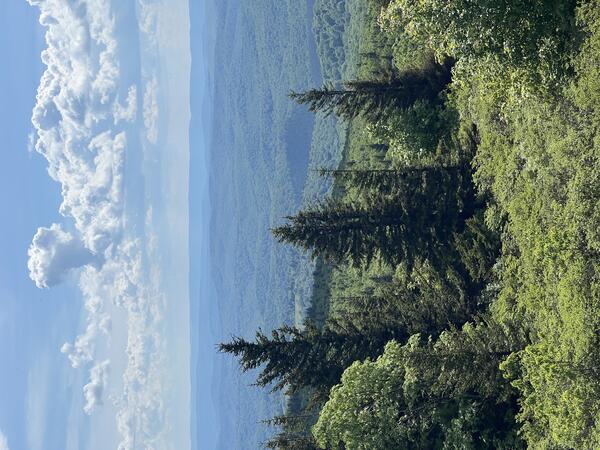
Spruce Knob, the highest point in West Virginia
Spruce Knob is the highest point in West Virginia, which offers incredible views of misty ridgelines and the unmistakable scent of spruce on cool mountain air.
Spruce Knob is the highest point in West Virginia, which offers incredible views of misty ridgelines and the unmistakable scent of spruce on cool mountain air.
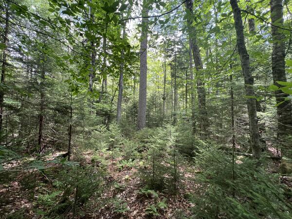
Red spruce forests in central Appalachia
USGS researchers with the Northeast Climate Adaptation Science Center (NE CASC) and Virginia Cooperative Fish and Wildlife Research Unit, and graduate students at Virginia Polytechnic Institute and State University (Va Tech) are working with the Central Appalachian Red Spruce Restoration Initiative, U.S. Forest Service, U.S.
USGS researchers with the Northeast Climate Adaptation Science Center (NE CASC) and Virginia Cooperative Fish and Wildlife Research Unit, and graduate students at Virginia Polytechnic Institute and State University (Va Tech) are working with the Central Appalachian Red Spruce Restoration Initiative, U.S. Forest Service, U.S.