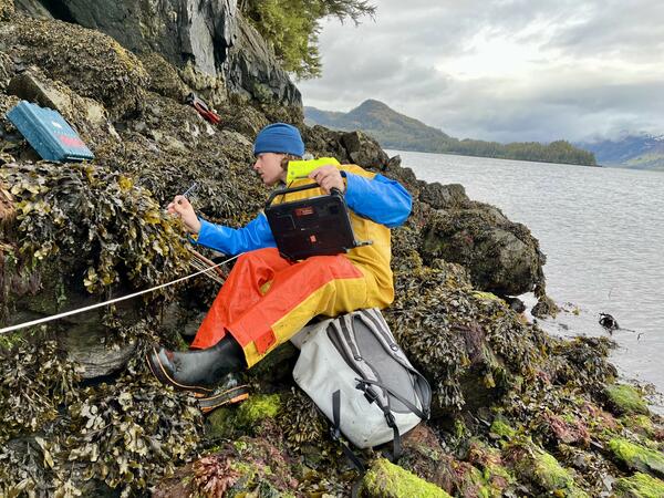
Boats and trailers can move invasive plants and animals between lakes. Aquatic invasive species are bad news and they need a plan for early detection and fast response.
Images
See our science through the images below.
Boats and trailers can move invasive plants and animals between lakes. Aquatic invasive species are bad news and they need a plan for early detection and fast response.
Technician is holding an invasive swamp eel in Central Florida
Technician is holding an invasive swamp eel in Central FloridaInvasive swamp eel (Monopterus albus) collected in central Florida. Swamp eels are used as bait and in live food markets and have the potential to impact the ecology and economics of a waterbody.
Distribution of Highly Pathogenic Avian Influenza H5 and H5N1 in North America, 2021-2025
Distribution of Highly Pathogenic Avian Influenza H5 and H5N1 in North America, 2021-2025Distribution of Highly Pathogenic Avian Influenza H5 and H5N1 in wild birds the United States, by county, 2021-2025. Updated February 10, 2025.
RestoreNet is a networked ecological restoration experiment spanning drylands of the American Southwest. It is engaging diverse partners to develop methods for successful revegetation projects that mitigate the effects of drought, invasion by non-native species, and land use practices.
A fisher retrieving his nets in the Rio Madre de Dios in Bolivia. Previously, fishers in the area reported abundant catches but nowadays it increasingly common for fishers to return home empty-handed because of impacts from dams and gold mining. (Photo credit: Gretchen Stokes)
Dozer Line through Repaired Habitat Supervised by SPARCS Fireline Resource Advisors during the Palisades Fire
Dozer Line through Repaired Habitat Supervised by SPARCS Fireline Resource Advisors during the Palisades FireBulldozer lines create breaks in vegetation and are commonly used when fighting wildfires. This dozer line was created during the Palisades Fire in Los Angeles County, California in January 2025.
The front elevation showcases a combination of glass and metal elements, reflecting a contemporary aesthetic. WHC will be a single, integrated, multistory, state-of-the-art building that will include offices, laboratories (BSL-2 and BSL-3), and vivarium
Picture provide by :Julia Lankton
Deputy Center Director
Conceptual illustration of the future USGS National Wildlife Health Center, courtesy of Flad Architects
Conceptual illustration of the future USGS National Wildlife Health Center, courtesy of Flad ArchitectsNWHC modernization overhead view, The image showcases an overhead view of the NWHC modernization project for the microsite homepage. Its highlighting the contemporary structures integrated into a vibrant landscape. Provided by: Lankton, Julia
Conceptual diagram of a potential SIR (susceptible - infected - recovered) model
Conceptual diagram of a potential SIR (susceptible - infected - recovered) modelA conceptual box-and-arrow diagram of avian influenza transmission. In each box, the first letter indicates low pathogenic avian influenza (LPAI) infection status (susceptible, infected, recovered) and the second indicates highly pathogenic avian influenza (HPAI) infection status.
Temperature logger attached to submerged cobble in Quartzville Creek, OR. This logger was placed as part of an ongoing effort to retrieve continuous temperature data from rivers and tributaries within the Willamette River basin, OR.
Covers of the National Seed Strategy and National Seed Strategy Progress Report for 2022 and 2023
Covers of the National Seed Strategy and National Seed Strategy Progress Report for 2022 and 2023Covers of the Plant Conservation Alliance National Seed Strategy Progress Report for 2022 and 2023 (left) and the National Seed Strategy for Rehabilitation and Restoration (right).
Cinnamon teal with a GPS tracking backpack that weighs 10 grams, making it much more successful in staying on longer than heavier tracking devices.
A RestoreNet Field Trial Network restoration experiment site in the Sonoran Desert, Arizona, in spring 2024. Photo by Laura Shriver (USGS).
Accomplishments in Native Seed Development in 2022 and 2023
Accomplishments in Native Seed Development in 2022 and 2023Accomplishments in Native Seed Development.
Accomplishments in Native Seed Development in 2022 and 2023
Accomplishments in Native Seed Development in 2022 and 2023Accomplishments in Native Seed Development.
Cattle inside a grazing enclosure at Canyonlands Research Center (The Nature Conservancy) in southern Utah.
Scenic view of the red rock mesas surrounding Canyonlands Research Center (The Nature Conservancy) in southern Utah.
Multidisciplinary approach to prioritize critical elements for environmental research.
Multidisciplinary approach to prioritize critical elements for environmental research.This infographic introduces an approach that could subsequently be used to prioritize environmental research for the full range of critical elements.
While it’s easy to assume there’s not much going on in deserts and other types of drylands, the opposite is true! Come with us to learn more about these underappreciated ecosystems; once you get to know them, we are sure you will love drylands as much as we do!
Map of locations of Ecosystems Mission Area locations across the U.S. This map includes the USGS Regions and Department of Interior Unified Regions.
Bison and elk feeding at the National Elk Refuge with map inset showing land holdings of core elk range around refuge
Bison and elk feeding at the National Elk Refuge with map inset showing land holdings of core elk range around refugeElk and bison being fed on the National Elk Refuge, Wyoming. Grand Teton and Grand Teton National Park are in the background. A map inset shows federal, state, and private land holdings of core winter elk range around the National Elk Refuge (labeled as the FWS unit). Map was generated by the USGS.
Winter elk range land holdings around National Elk Refuge
Winter elk range land holdings around National Elk RefugeMap showing federal, state, and private land holdings of core winter elk range around the National Elk Refuge (labeled as the FWS unit). Map was generated by the USGS.
Winter elk range land holdings around National Elk Refuge
Winter elk range land holdings around National Elk RefugeMap showing federal, state, and private land holdings of core winter elk range around the National Elk Refuge (labeled as the FWS unit). Map was generated by the USGS.