
Screenshot of Nebraska water dashboard. This image was added to use as an example of a resource on the Nebraska Water Science Center Home page.
Images
Explore water-related photography, imagery, and illustrations.
Filter Total Items: 2553

Nebraska Water Dashboard screenshot
Screenshot of Nebraska water dashboard. This image was added to use as an example of a resource on the Nebraska Water Science Center Home page.
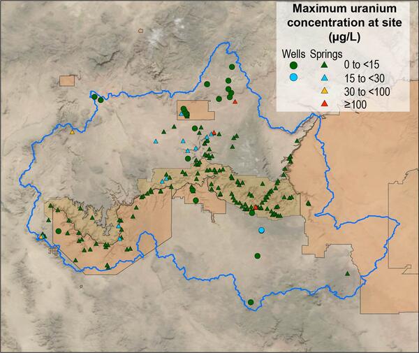
Map of Grand Canyon uranium concentrations as spring and well sites
Map of Grand Canyon uranium concentrations as spring and well sitesMap of maximum uranium concentration at 206 spring and well sites in the Grand Canyon region.
Map of Grand Canyon uranium concentrations as spring and well sites
Map of Grand Canyon uranium concentrations as spring and well sitesMap of maximum uranium concentration at 206 spring and well sites in the Grand Canyon region.

October 2021 USGS Active Groundwater Level Network Animation
October 2021 USGS Active Groundwater Level Network AnimationThe USGS Active Groundwater Level Network includes about 20,000 wells that have been measured by the USGS or USGS cooperators at least once within the past 13 months. The animation shows snapshots of water-level statistics in the network during Octobers 2021.

USGS Scientist Conducts Groundwater Slug Test
In this photo, USGS scientist Martha Nielsen conducts a slug test in a groundwater well completed in bedrock. During a slug test, a hydrologist causes the water level in a well to increase or decrease rapidly, while measuring the water-level response in the well over time.
In this photo, USGS scientist Martha Nielsen conducts a slug test in a groundwater well completed in bedrock. During a slug test, a hydrologist causes the water level in a well to increase or decrease rapidly, while measuring the water-level response in the well over time.

Kenna Grubb measuring on the Holston River
Photo Contest Winner | September 2021 | Honorable Mention 1
Kenna Grubb measuring on the Holston River
Photo Contest Winner | September 2021 | Honorable Mention 1
Kenna Grubb measuring on the Holston River

Ruby Lake National Wildlife Reserve
Ruby Lake National Wildlife Refuge lies at the southern end of Ruby Valley in northeast Nevada. For more information visit the Ruby Lake NWR website.
By
Ecosystems Mission Area, Water Resources Mission Area, Land Management Research Program, Water Availability and Use Science Program, Climate Adaptation Science Centers, Forest and Rangeland Ecosystem Science Center, Fort Collins Science Center, Nevada Water Science Center, Oregon Water Science Center, Utah Water Science Center, Western Ecological Research Center (WERC), Saline Lakes Ecosystems Integrated Water Availability Assessment

September 2021 USGS Active Groundwater Level Network Animation
September 2021 USGS Active Groundwater Level Network AnimationThe USGS Active Groundwater Level Network includes about 20,000 wells that have been measured by the USGS or USGS cooperators at least once within the past 13 months. The animation shows snapshots of water-level statistics in the network during September 2021.

Hurricane Ida Water Footprint Data Visualization
Hurricane Ida made landfall as a Category 4 hurricane in Louisiana, and brought widespread precipitation and flooding along its path and up the northeastern coast of U.S. in the following week.
Hurricane Ida made landfall as a Category 4 hurricane in Louisiana, and brought widespread precipitation and flooding along its path and up the northeastern coast of U.S. in the following week.

August 2021 USGS Active Groundwater Level Network Animation
August 2021 USGS Active Groundwater Level Network AnimationThe USGS Active Groundwater Level Network includes about 20,000 wells that have been measured by the USGS or USGS cooperators at least once within the past 13 months. The animation shows snapshots of water-level statistics in the network during August 2021.

Liz Nystrom captaining a boat on the Hudson River
Photo Contest Winner | September 2021 | Honorable Mention 2
Liz Nystrom captaining a boat on the Hudson River
Photo Contest Winner | September 2021 | Honorable Mention 2
Liz Nystrom captaining a boat on the Hudson River

Hurricane Henri Water Footprint Data Visualization
Hurricane Henri Water Footprint Data VisualizationAn animated map of tropical storm Henri that made landfall in Rhode Island on Sunday, August 22, 2021. The map shows the east coast of the United States from Maryland to Maine, with the storm path traveling from the Atlantic Ocean north to make land in Rhode Island.

Pack Creek at Pack Creek Road Bridge river gage
Photo looking downstream from the Pack Creek Road Bridge shows the rain gage on top with a USGS sticker. Below is a solar panel for power. The other white round object contains the data logger and satellite antenna.
Photo looking downstream from the Pack Creek Road Bridge shows the rain gage on top with a USGS sticker. Below is a solar panel for power. The other white round object contains the data logger and satellite antenna.

Neil Terry preparing for resistivity surveys in Northern Minnesota
Neil Terry preparing for resistivity surveys in Northern MinnesotaPhoto Contest Winner | September 2021 | USGS at Work
USGS Research Hyrologist Neil Terry preparing for resistivity surveys in Northern Minnesota
Neil Terry preparing for resistivity surveys in Northern Minnesota
Neil Terry preparing for resistivity surveys in Northern MinnesotaPhoto Contest Winner | September 2021 | USGS at Work
USGS Research Hyrologist Neil Terry preparing for resistivity surveys in Northern Minnesota
July 2021 USGS Active Groundwater Level Network Animation
July 2021 USGS Active Groundwater Level Network AnimationThe USGS Active Groundwater Level Network includes about 20,000 wells that have been measured by the USGS or USGS cooperators at least once within the past 13 months. The animation shows snapshots of water-level statistics in the network during July 2021.

Chany Huddleston and Ross Clyma prepare QBoat at Schoharie Creek
Chany Huddleston and Ross Clyma prepare QBoat at Schoharie CreekPhoto Contest Winner | September 2021 | Where We Work
Chany Huddleston and Ross Clyma prepare QBoat at Schoharie Creek
Chany Huddleston and Ross Clyma prepare QBoat at Schoharie Creek
Chany Huddleston and Ross Clyma prepare QBoat at Schoharie CreekPhoto Contest Winner | September 2021 | Where We Work
Chany Huddleston and Ross Clyma prepare QBoat at Schoharie Creek

Great Salt Lake Reaches New Historic Low
USGS hydrologic technician Travis Gibson confirms Great Salt Lake water levels at the SaltAire gauge.
USGS hydrologic technician Travis Gibson confirms Great Salt Lake water levels at the SaltAire gauge.

Great Salt Lake Reaches New Historic Low
A sailboat is removed from the Great Salt Lake Marina due to low lake levels.
A sailboat is removed from the Great Salt Lake Marina due to low lake levels.

Great Salt Lake May Reach Historic Low Soon
Decreasing water levels in the southern arm of the Great Salt Lake expose microbialite communities that are normally underwater.
Decreasing water levels in the southern arm of the Great Salt Lake expose microbialite communities that are normally underwater.

June 2021 USGS Active Groundwater Level Network Animation
June 2021 USGS Active Groundwater Level Network AnimationThe USGS Active Groundwater Level Network includes about 20,000 wells that have been measured by the USGS or USGS cooperators at least once within the past 13 months. The animation shows snapshots of daily water-level statistics in the network for June 2021.

Climate station locations, U.S. Environmental Protection Agency (EPA)-defined North America Level III ecoregions (ecoregions), and California Department of Water Resources (CDWR) full natural flow (FNF) hydrological basins.
Climate station locations, U.S. Environmental Protection Agency (EPA)-defined North America Level III ecoregions (ecoregions), and California Department of Water Resources (CDWR) full natural flow (FNF) hydrological basins.FIG. 1. Study area, climate station locations, U.S. Environmental Protection Agency (EPA)-defined North America Level III ecoregions (ecoregions), and California Department of Water Resources (CDWR) full natural flow (FNF) hydrological basins.
Climate station locations, U.S. Environmental Protection Agency (EPA)-defined North America Level III ecoregions (ecoregions), and California Department of Water Resources (CDWR) full natural flow (FNF) hydrological basins.
Climate station locations, U.S. Environmental Protection Agency (EPA)-defined North America Level III ecoregions (ecoregions), and California Department of Water Resources (CDWR) full natural flow (FNF) hydrological basins.Climate station locations, U.S. Environmental Protection Agency (EPA)-defined North America Level III ecoregions (ecoregions), and California Department of Water Resources (CDWR) full natural flow (FNF) hydrological basins.
Climate station locations, U.S. Environmental Protection Agency (EPA)-defined North America Level III ecoregions (ecoregions), and California Department of Water Resources (CDWR) full natural flow (FNF) hydrological basins.FIG. 1. Study area, climate station locations, U.S. Environmental Protection Agency (EPA)-defined North America Level III ecoregions (ecoregions), and California Department of Water Resources (CDWR) full natural flow (FNF) hydrological basins.

Lees Ferry streamgage and cableway on the Colorado River, Arizona
Lees Ferry streamgage and cableway on the Colorado River, ArizonaLees Ferry streamgage and cableway downstream on the Colorado River, Arizona
Lees Ferry streamgage and cableway on the Colorado River, Arizona
Lees Ferry streamgage and cableway on the Colorado River, ArizonaLees Ferry streamgage and cableway downstream on the Colorado River, Arizona