
Overlooking Lake Mead.
Images
Explore water-related photography, imagery, and illustrations.
Filter Total Items: 2553

Lake Mead

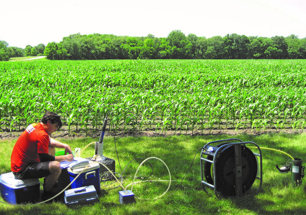
Evaluating the Fate of Methane Released into Streams
Evaluating the Fate of Methane Released into StreamsScientists apply a new method for determining the fate of methane discharged into streams. Here, gas is injected into stream water along West Bear Creek, North Carolina.
Evaluating the Fate of Methane Released into Streams
Evaluating the Fate of Methane Released into StreamsScientists apply a new method for determining the fate of methane discharged into streams. Here, gas is injected into stream water along West Bear Creek, North Carolina.

Surveying a high-water mark on Liberty Island, after Hurricane Sandy
Surveying a high-water mark on Liberty Island, after Hurricane SandyUSGS hydrologic technician Amy Simonson surveying a high-water mark on Liberty Island, New York after Hurricane Sandy
Surveying a high-water mark on Liberty Island, after Hurricane Sandy
Surveying a high-water mark on Liberty Island, after Hurricane SandyUSGS hydrologic technician Amy Simonson surveying a high-water mark on Liberty Island, New York after Hurricane Sandy

Niskin bottle
Black tape is stretched across the stopper of the 'Niskin' bottle and secured to form a positive pressure seal.
Black tape is stretched across the stopper of the 'Niskin' bottle and secured to form a positive pressure seal.

Humpback Rocks Views
Humpback Rocks Views

Predicted arsenic concentrations in Southwest basin-fill aquifers
Predicted arsenic concentrations in Southwest basin-fill aquifersPredicted concentrations of arsenic in groundwater exceed the Maximum Contaminant Level (MCL) of 10 μg/L in 43 percent of the areal extent of the four Southwest basin-fill aquifers.

An Appalachian Mountain Stream in the Spring
An Appalachian Mountain Stream in the Spring. Photographed by Samuel H Austin
An Appalachian Mountain Stream in the Spring. Photographed by Samuel H Austin

USGS Water towers
USGS Water towers at Upper Midwest Environmental Sciences Center
USGS Water towers at Upper Midwest Environmental Sciences Center

2012 SPARROW Models for the Midwest
2012 SPARROW Models for the Midwest: Total Phosphorus, Total Nitrogen, Suspended Sediment, and Streamflow
2012 SPARROW Models for the Midwest: Total Phosphorus, Total Nitrogen, Suspended Sediment, and Streamflow
Sampling a shallow monitoring well representing agricultural land use
Sampling a shallow monitoring well representing agricultural land useUSGS collects groundwater from shallow monitoring wells beneath agricultural and urban areas to assess the effects of these activities on recently recharged groundwater as part of the National Water Quality Network (NWQN).

Phosphorus Filter
Tom Kehler, fishery biologist at the U.S.
Tom Kehler, fishery biologist at the U.S.

Dried Acid Mine Drainage Residuals
Dried acid mine drainage residuals that are formed during treatment of the drainage. The USGS has pioneered a new use for these residuals that are currently a disposal challenge, using them to filter phosphorus from agricultural and municipal wastewaters.
Dried acid mine drainage residuals that are formed during treatment of the drainage. The USGS has pioneered a new use for these residuals that are currently a disposal challenge, using them to filter phosphorus from agricultural and municipal wastewaters.

Liberty State Park
Liberty State Park, Jersey City, NJ; Chad Ostheimer surveying a high-water mark left October 29, 2012 by Hurricane Sandy.
Liberty State Park, Jersey City, NJ; Chad Ostheimer surveying a high-water mark left October 29, 2012 by Hurricane Sandy.

Hurricane Sandy flood effects 2012, Mantoloking, NJ
Hurricane Sandy flood effects 2012, Mantoloking, NJHurricane Sandy struck the New Jersey shore Oct. 29-31, 2012. This house in Mantoloking, NJ was partly collapsed after Hurricane Sandy's storm tide receded.
Hurricane Sandy flood effects 2012, Mantoloking, NJ
Hurricane Sandy flood effects 2012, Mantoloking, NJHurricane Sandy struck the New Jersey shore Oct. 29-31, 2012. This house in Mantoloking, NJ was partly collapsed after Hurricane Sandy's storm tide receded.

Hurricane Sandy flood effects 2012, Seaside Heights NJ
Hurricane Sandy flood effects 2012, Seaside Heights NJHurricane Sandy struck the New Jersey shore Oct. 29-31, 2012. Houses, cars and a street in Seaside Heights, NJ were covered in beach sand after Hurricane Sandy's storm tide receded.
Hurricane Sandy flood effects 2012, Seaside Heights NJ
Hurricane Sandy flood effects 2012, Seaside Heights NJHurricane Sandy struck the New Jersey shore Oct. 29-31, 2012. Houses, cars and a street in Seaside Heights, NJ were covered in beach sand after Hurricane Sandy's storm tide receded.

Faulting in limestone outcrop, Greenwood Creek
Faulting in limestone outcrop downstream from where Greenwood Creek flows into the Colorado River, October 31, 2012 (photograph by Jennifer Wilson, U.S. Geological Survey).
SIR 2015–5098
Faulting in limestone outcrop downstream from where Greenwood Creek flows into the Colorado River, October 31, 2012 (photograph by Jennifer Wilson, U.S. Geological Survey).
SIR 2015–5098

Seeps along limestone outcrop, Jim John Creek
Seeps along limestone outcrop downstream from where Jim John Creek flows into the Colorado River, October 31, 2012 (photograph by Jennifer Wilson, U.S. Geological Survey).
SIR 2015–5098
Seeps along limestone outcrop downstream from where Jim John Creek flows into the Colorado River, October 31, 2012 (photograph by Jennifer Wilson, U.S. Geological Survey).
SIR 2015–5098

Travertine deposits, Post Oak Falls near Tow, Texas
Travertine deposits, Post Oak Falls near Tow, TexasTravertine deposits near site 4 (Post Oak Falls near Tow, Texas, October 31, 2012) (photograph by Jennifer Wilson, U.S. Geological Survey).
SIR 2015–5098
Travertine deposits, Post Oak Falls near Tow, Texas
Travertine deposits, Post Oak Falls near Tow, TexasTravertine deposits near site 4 (Post Oak Falls near Tow, Texas, October 31, 2012) (photograph by Jennifer Wilson, U.S. Geological Survey).
SIR 2015–5098

Sandbar growth Grand Canyon following controlled flood
Sandbar growth Grand Canyon following controlled floodPicture showing the increased size of the sandbar after the November 2012 controlled flood from the Glen Canyon Dam. This location is 65 miles downstream from Lees Ferry and the view is looking downstream. These and additional photographs depicting the results of the recent controlled floods can be viewed online.

USGS scientists, Michael Noll and Amy Simonson, installing storm surge sensors before Hurricane Sandy
USGS scientists, Michael Noll and Amy Simonson, installing storm surge sensors before Hurricane SandyUSGS scientists, Michael Noll and Amy Simonson, installing storm surge sensors before Hurricane Sandy

Chicago River mainstem, Chicago, Illinois
Looking west down Chicago River mainstem from the Chicago River Controlling Works where water enters from Lake Michigan.
Looking west down Chicago River mainstem from the Chicago River Controlling Works where water enters from Lake Michigan.