
Streams and Rivers
Streams and Rivers
Filter Total Items: 119

Flood Inundation Mapping Science
When planning for a flood, there are three key questions that must be answered: What areas will be flooded? How deep will the floodwaters get? When will the flood arrive? A flood inundation map library is a set of maps that together show where flooding may occur – and how deep it may be - over a range of potential flooding scenarios in a stream or river.

Flood Inundation Mapping (FIM) Program
The USGS Flood Inundation Mapping (FIM) Program helps communities protect lives and property by providing tools and information to help them understand their local flood risks and make cost-effective mitigation decisions.
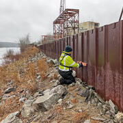
High-Water Marks
High-water marks are like footprints left behind by a flood — they show how high the water reached during a flood event. High-water marks serve as valuable data points for both educational purposes and scientific research, helping us understand past and recent flood events. Collecting this information is an essential and time-sensitive task for understanding flood risk and improving public safety.

National Water Monitoring Network
To manage our water resources effectively, we need to understand how much water is available and its usefulness. The USGS monitors the nation’s water resources through various national observing networks that use a range of technologies and methods to assess real-time water conditions and predict future changes in water availability for human and ecological uses.

Reconstructing Flow History From Riparian Tree Rings
FORT aquatic scientists analyze rings of riparian trees relating tree growth and establishment to historical flow. They then use the tree rings to reconstruct the flow in past centuries. Flow reconstructions discover the frequency and magnitude of past droughts and floods—information that is essential for management of rivers and water supplies. They have pioneered the use of cottonwood, a...

National Water Availability Assessments
The USGS National Water Availability Assessment consists of reports, which provide a scientific summary and interpretation of water quantity, quality and use, and the data companion, which delivers model-based estimates of water supply and demand.

Regional Water Availability Assessments
Regional Water Availability Assessments are scientific assessments of water availability in different hydrologic regions across the Nation. They are designed to capture a range of conditions in major drivers of water availability.

Integrated Water Availability Assessments
The USGS Water Resources Mission Area is assessing how much water is available for human and ecological needs in the United States and identifying where and when the Nation may have challenges meeting its demand for water.

Integrated Water Availability Assessments Fundamentals
The USGS Water Resources Mission Area is assessing how much water is available for human and ecological needs in the United States and identifying where and when the Nation may have challenges meeting its demand for water.

National Water Availability Assessment Data Companion
The National Water Availability Assessment Data Companion (NWDC) delivers model-based estimates of water supply and demand.

USGS National Streamgaging Network
As of October 2024, the USGS Groundwater and Streamflow Information Program supports the collection and (or) delivery of both streamflow and water-level information at 8,705 sites and water-level information alone at 3,460 additional sites. The data are served online—most in near real-time—to meet many diverse needs including the protection of life, property, the environment, and our economy.

Centennial Streamgages
Centennial Streamgages are USGS streamgages that have been in operation for more than 100 years.