
Techniques and Methods
Techniques and Methods
Filter Total Items: 35
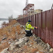
High-Water Marks
High-water marks are like footprints left behind by a flood — they show how high the water reached during a flood event. High-water marks serve as valuable data points for both educational purposes and scientific research, helping us understand past and recent flood events. Collecting this information is an essential and time-sensitive task for understanding flood risk and improving public safety.

National Water Monitoring Network
To manage our water resources effectively, we need to understand how much water is available and its usefulness. The USGS monitors the nation’s water resources through various national observing networks that use a range of technologies and methods to assess real-time water conditions and predict future changes in water availability for human and ecological uses.

National Water Availability Assessments
The USGS National Water Availability Assessment consists of reports, which provide a scientific summary and interpretation of water quantity, quality and use, and the data companion, which delivers model-based estimates of water supply and demand.

Regional Water Availability Assessments
Regional Water Availability Assessments are scientific assessments of water availability in different hydrologic regions across the Nation. They are designed to capture a range of conditions in major drivers of water availability.

Integrated Water Availability Assessments
The USGS Water Resources Mission Area is assessing how much water is available for human and ecological needs in the United States and identifying where and when the Nation may have challenges meeting its demand for water.

MODFLOW and Related Programs
MODFLOW is the USGS's modular hydrologic model. MODFLOW is considered an international standard for simulating and predicting groundwater conditions and groundwater/surface-water interactions. MODFLOW 6 is presently the core MODFLOW version distributed by the USGS.

Integrated Water Science (IWS) Basins
The U.S. Geological Survey is integrating its water science programs to better address the Nation’s greatest water resource challenges. At the heart of this effort are plans to intensively study several Integrated Water Science (IWS) basins—medium-sized watersheds (10,000-20,000 square miles) and underlying aquifers—over the next decade. The IWS basins will represent a wide range of environmental...

Next Generation Water Observing System (NGWOS)
The Next Generation Water Observing System (NGWOS) supports water availability assessments, management, and prediction by enhancing water observations in basins that represent major U.S. hydrologic regions. NGWOS provides high-resolution, real-time data on water quantity, quality, and use, as well as advance the development and application of new sensor technologies and remote sensing methods.

Atmospheric Warming, Loss of Snow Cover, and Declining Colorado River Flow
Declining snow cover is playing a key role in decreasing the flow of the Colorado River, “the lifeblood of the Southwest,” by enabling increased evaporation. As the warming continues, increasingly severe water shortages are expected.

National Water Quality Laboratory (NWQL)
Offering a wide-range of environemental analytical services, the U.S. Geological Survey (USGS) National Water Quality Laboratory (NWQL) is a world-class environmental analysis and research laboratory located on the campus of the Denver Federal Center in Lakewood, Colorado.

Integration of sUAS into Hydrogeophysical Studies
The USGS is evaluating the integration of small unoccupied aircraft systems – sUAS or "drones" – into USGS hydrogeophysical studies.

StreamStats
StreamStats provides access to spatial analytical tools that are useful for water-resources planning and management, and for engineering and design purposes. The map-based user interface can be used to delineate drainage areas, get basin characteristics and estimates of flow statistics, and more. Available information varies from state to state.