
Providing Major Storm and Short-Term Flood Event Data
During major storms or other short-term events, the USGS collects streamflow and additional data to help document high-water events. This data is uploaded to the Short-Term Network (STN) for long-term archival and served out to the public through the Flood Event Viewer (FEV) which provides convenient, map-based access to downloadable event-based data.
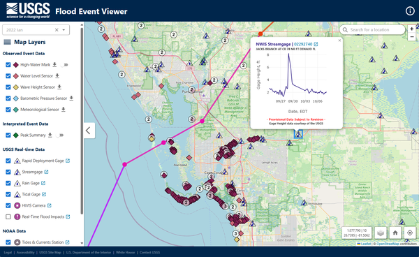
The USGS streamgage network is the largest in the U.S., but even with over 9,000 active real-time streamgages monitoring river discharge, additional data are often needed to respond to and document major storms or other short-term events. During these events, the USGS collects additional data from temporary sensor deployments, including storm tide, wave height, high-water marks (HWM), and additional sensor deployments. These short-term event data are uploaded to the USGS Short-Term Network (STN) for long-term archival and made publicly available through the USGS Flood Event Viewer (FEV), which provides convenient, map-based access to storm-surge and other event-based data.
The USGS uses the STN system to collect, store, quality-assure, manage, and deliver HWM and short-term sensor data for flood events. The STN's short-term event data are used by researchers from the USGS and other public and private entities to study and document flood events, develop inundation maps, evaluate coastal impacts, validate gage peaks, and many other applications.
The USGS Flood Event Viewer (FEV) is a national-scale application and database supporting the USGS Storm-Tide Program and HWM data collection efforts. The FEV application integrates with USGS Water Data for the Nation data (rain, tidal, and streamgages) for display of time-series water data, which are maintained independently of FEV and STN. The FEV also integrates historical hurricane tracks from the National Ocean and Atmospheric Administration (NOAA), the USGS Hydrologic Imagery Visualization and Information System (HIVIS) cameras, and NOAA Tides and Currents Stations.
There are many ways to access flood event data through the Flood Event Viewer:
Below are other science topics associated with flood response.

USGS Flood Information

Flood Inundation Mapping (FIM) Program

Rapid Deployment Gages (RDGs)

Surge, Wave, and Tide Hydrodynamics (SWaTH) Network

Historical Flooding
During major storms or other short-term events, the USGS collects streamflow and additional data to help document high-water events. This data is uploaded to the Short-Term Network (STN) for long-term archival and served out to the public through the Flood Event Viewer (FEV) which provides convenient, map-based access to downloadable event-based data.
The USGS streamgage network is the largest in the U.S., but even with over 9,000 active real-time streamgages monitoring river discharge, additional data are often needed to respond to and document major storms or other short-term events. During these events, the USGS collects additional data from temporary sensor deployments, including storm tide, wave height, high-water marks (HWM), and additional sensor deployments. These short-term event data are uploaded to the USGS Short-Term Network (STN) for long-term archival and made publicly available through the USGS Flood Event Viewer (FEV), which provides convenient, map-based access to storm-surge and other event-based data.
The USGS uses the STN system to collect, store, quality-assure, manage, and deliver HWM and short-term sensor data for flood events. The STN's short-term event data are used by researchers from the USGS and other public and private entities to study and document flood events, develop inundation maps, evaluate coastal impacts, validate gage peaks, and many other applications.
The USGS Flood Event Viewer (FEV) is a national-scale application and database supporting the USGS Storm-Tide Program and HWM data collection efforts. The FEV application integrates with USGS Water Data for the Nation data (rain, tidal, and streamgages) for display of time-series water data, which are maintained independently of FEV and STN. The FEV also integrates historical hurricane tracks from the National Ocean and Atmospheric Administration (NOAA), the USGS Hydrologic Imagery Visualization and Information System (HIVIS) cameras, and NOAA Tides and Currents Stations.
There are many ways to access flood event data through the Flood Event Viewer:
Below are other science topics associated with flood response.
USGS Flood Information
Flood Inundation Mapping (FIM) Program
Rapid Deployment Gages (RDGs)
Surge, Wave, and Tide Hydrodynamics (SWaTH) Network