U.S. flag

An official website of the United States government

Images

Explore our planet through photography and imagery, including climate change and water all the way back to the 1800s when the USGS was surveying the country by horse and buggy.

Filter Total Items: 21609
Liz Nystrom captaining a boat on the Hudson River

Photo Contest Winner | September 2021 | Honorable Mention 2

Liz Nystrom captaining a boat on the Hudson River

Photo Contest Winner | September 2021 | Honorable Mention 2

Liz Nystrom captaining a boat on the Hudson River

On August 31, the water level in Keller Well was measured at approximately 514.12 m (1686.75 ft) below the ground surface
Sampling Keller Well in Kīlauea’s south caldera region

On August 31, the water level in Keller Well was measured at approximately 514.12 m (1686.75 ft) below the ground surface. Though an intrusion of magma took place beneath the ground surface in Kīlauea's south caldera region from August 23–30, water level in Keller Well does not show significant changes as a result of this event. USGS image by P. Nadeau.

On August 31, the water level in Keller Well was measured at approximately 514.12 m (1686.75 ft) below the ground surface. Though an intrusion of magma took place beneath the ground surface in Kīlauea's south caldera region from August 23–30, water level in Keller Well does not show significant changes as a result of this event. USGS image by P. Nadeau.

On August 31, Hawaiian Volcano Observatory scientists and technicians visited the Keller Well in Kīlauea's south caldera region
Sampling Keller Well in Kīlauea’s south caldera region

On Tuesday, August 31, Hawaiian Volcano Observatory (HVO) scientists and technicians visited the Keller Well in Kīlauea's south caldera region. Water from the well is typically sampled and analyzed quarterly to monitor how magma supply to Kīlauea's summit reservoirs might impact regional ground water.

On Tuesday, August 31, Hawaiian Volcano Observatory (HVO) scientists and technicians visited the Keller Well in Kīlauea's south caldera region. Water from the well is typically sampled and analyzed quarterly to monitor how magma supply to Kīlauea's summit reservoirs might impact regional ground water.

View of a shoreline with a wooden pole supported by wires and secured to the soil, with a pickup truck parked nearby.
Video camera setup at Nuvuk, Alaska

Point Barrow, Alaska, or Nuvuk, is the northernmost point in the United States. USGS has set up video cameras, mounted to the pole shown here, to study sediment movement and wave dynamics along this dynamic coastline.

Point Barrow, Alaska, or Nuvuk, is the northernmost point in the United States. USGS has set up video cameras, mounted to the pole shown here, to study sediment movement and wave dynamics along this dynamic coastline.

View of a shoreline of soil near the ocean with wooden poles sitting atop a large berm.
Video camera setup at Point Barrow, Alaska

Point Barrow, Alaska, or Nuvuk, is the northernmost point in the United States. USGS has set up video cameras, mounted to the pole shown here, to study sediment movement and wave dynamics along this dynamic coastline.

Point Barrow, Alaska, or Nuvuk, is the northernmost point in the United States. USGS has set up video cameras, mounted to the pole shown here, to study sediment movement and wave dynamics along this dynamic coastline.

A pole with instruments strapped to it is supported by wires and stands on a coastal bluff with the ocean in the background.
Video camera setup, Point Barrow, Alaska

Point Barrow, Alaska, or Nuvuk, is the northernmost point in the United States. USGS has set up video cameras, mounted to the pole shown here, to study sediment movement and wave dynamics along this dynamic coastline.

Point Barrow, Alaska, or Nuvuk, is the northernmost point in the United States. USGS has set up video cameras, mounted to the pole shown here, to study sediment movement and wave dynamics along this dynamic coastline.

Map of volcano summit
Map of intrusive activity at Kīlauea Volcano―August 23–30, 2021

This map depicts the detected intrusive activity over the past week at Kīlauea Volcano. The initial swarm of small earthquakes from August 23–25 was centered in the south caldera region, as labelled on the map.

This map depicts the detected intrusive activity over the past week at Kīlauea Volcano. The initial swarm of small earthquakes from August 23–25 was centered in the south caldera region, as labelled on the map.

Extracting pore water from Yellowstone Lake sediment cores

Pore waters from Yellowstone Lake sediment cores collected in August 2021 are extracted through filtration devices into plastic syringes.  Note that the second core from the left appears light in color because the plastic core liner was etched by very hot 91°C (196°F) fluids.

Pore waters from Yellowstone Lake sediment cores collected in August 2021 are extracted through filtration devices into plastic syringes.  Note that the second core from the left appears light in color because the plastic core liner was etched by very hot 91°C (196°F) fluids.

Gravity coring device after sampling Yellowstone Lake sediment

Gravity coring device on the rear deck of the R/V Annie after coring the floor of Yellowstone Lake, with dark mud coating the outside of the corer.  The 100-lb. green coring head is at the top, and the bottom of the barrel has a tapered stainless steel core cutter.

Gravity coring device on the rear deck of the R/V Annie after coring the floor of Yellowstone Lake, with dark mud coating the outside of the corer.  The 100-lb. green coring head is at the top, and the bottom of the barrel has a tapered stainless steel core cutter.

R/V Annie leaves Bridge Bay, Yellowstone National Park

View to the aft of the R/V Annie as it leaves Bridge Bay Marina early in the morning of August 26, 2021.

View to the aft of the R/V Annie as it leaves Bridge Bay Marina early in the morning of August 26, 2021.

Animation showing rain totals and water levels in the northeast US during Hurricane Henri.
Hurricane Henri Water Footprint Data Visualization

An animated map of tropical storm Henri that made landfall in Rhode Island on Sunday, August 22, 2021. The map shows the east coast of the United States from Maryland to Maine, with the storm path traveling from the Atlantic Ocean north to make land in Rhode Island.

An animated map of tropical storm Henri that made landfall in Rhode Island on Sunday, August 22, 2021. The map shows the east coast of the United States from Maryland to Maine, with the storm path traveling from the Atlantic Ocean north to make land in Rhode Island.

Map of seismic activity
Map showing Kīlauea south caldera seismicity August 23-25, 2021

Map showing the seismic activity beneath the south part of Kīlauea caldera, within Hawaiʻi Volcanoes National Park, from August 23, 2021, at noon through the same time on August 25, 2021. The earthquake swarm began in that region at around 4:30 p.m. HST on August 23 and continued until the morning of August 25, 2021.

Map showing the seismic activity beneath the south part of Kīlauea caldera, within Hawaiʻi Volcanoes National Park, from August 23, 2021, at noon through the same time on August 25, 2021. The earthquake swarm began in that region at around 4:30 p.m. HST on August 23 and continued until the morning of August 25, 2021.

Two aerial photos of the southern part of Florida labeled with asset and people loss due to coral reef damage.
Annual coastal hazard risk increase due to hurricanes in Florida

Maps for the southern part of the Florida coastline show the increase in annual coastal hazard risk due to damage by Hurricanes Irma and Maria.

  1. Increase in population at risk due to coral reef damage per kilometer (left)
  2. Increase in value ($) of assets at risk due to coral reef damage per kilometer (right)
Folleto con texto y una vista aérea mirando hacia abajo en una costa con columnas que representan valores de datos en la costa.
Beneficios sociales y económicos de la restauración: Puerto Rico 1

RESUMEN DEL REPORTE

Los beneficios sociales y económicos de la restauración de arrecifes de coral en Puerto Rico

PUNTOS CLAVE

Folleto con texto y una vista aérea mirando hacia abajo en una costa con puntos que representan valores de datos en la costa.
Beneficios sociales y económicos de la restauración: Puerto Rico 2

La restauración de los arrecifes de coral puede producir beneficios significativos en la reducción de inundaciones. Estas defensas naturales sufrieron daños a causa de los huracanes de 2017; su recuperación reduciría riesgos adicionales a la naturaleza, las personas y propiedades causados por tormentas.

La restauración de los arrecifes de coral puede producir beneficios significativos en la reducción de inundaciones. Estas defensas naturales sufrieron daños a causa de los huracanes de 2017; su recuperación reduciría riesgos adicionales a la naturaleza, las personas y propiedades causados por tormentas.

Four aerial photos of the southern part of Florida labeled with asset and people loss due to elevation and erosion degradation.
Coastal hazard risk increase due to reef degradation: Florida

Four scenarios for the southern part of the Florida coastline show the increase in annual coastal hazard risk due to projected coral reef degradation.

Four scenarios for the southern part of the Florida coastline show the increase in annual coastal hazard risk due to projected coral reef degradation.

Brochure with text and an aerial view looking down on a coast with areas of projected reef loss.
Future Flooding Impacts from Projected Coral Reef Degradation in FL, 1

Report Summary

Future Flooding Impacts from Projected Coral Reef Degradation in Florida

Projected future degradation of reef natural infrastructure puts U.S. people and property at significant risk of future flooding.

Key Points

Report Summary

Future Flooding Impacts from Projected Coral Reef Degradation in Florida

Projected future degradation of reef natural infrastructure puts U.S. people and property at significant risk of future flooding.

Key Points

Brochure with text and an aerial view looking down on a coast with dots depicting data values along the coast.
Future Flooding Impacts from Projected Coral Reef Degradation in FL, 2

Future flooding on Florida’s reef-lined coasts would increase by 16% if present reef loss continues.

Folleto con texto y una vista aérea mirando hacia abajo en una costa con columnas que representan valores de datos en la costa.
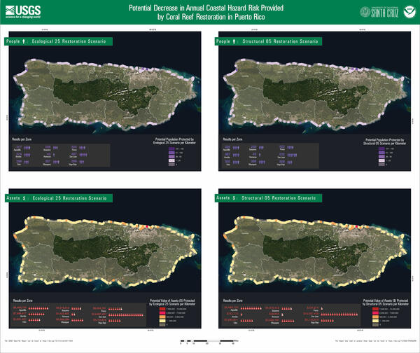
Huracanes aumentan el riesgo de inundaciones futuras en Puerto Rico, 1

RESUMEN DEL REPORTE

Los daños causados ​​por los huracanes a los arrecifes de coral en 2017 aumentan el riesgo de inundaciones futuras en Puerto Rico y Florida

RESUMEN DEL REPORTE

Los daños causados ​​por los huracanes a los arrecifes de coral en 2017 aumentan el riesgo de inundaciones futuras en Puerto Rico y Florida

Folleto con texto y una vista aérea mirando hacia abajo en una costa con puntos que representan valores de datos en la costa.
Huracanes aumentan el riesgo de inundaciones futuras en Puerto Rico, 2

Las consecuencias significativas del riesgo de inundación debido a los daños en los arrecifes de coral causado por los huracanes Irma y María clarifican por qué los beneficios de defensa de esta infraestructura natural deben recuperarse, repararse y restaurarse.

Las consecuencias significativas del riesgo de inundación debido a los daños en los arrecifes de coral causado por los huracanes Irma y María clarifican por qué los beneficios de defensa de esta infraestructura natural deben recuperarse, repararse y restaurarse.

Brochure with text and an aerial view looking down on a coast with columns depicting data values along the coast.
Hurricanes increase future flood risk in Puerto Rico and Florida, 1

Report Summary

Hurricane Damage to Coral Reefs in 2017 Increases Future Flood Risk in Puerto Rico and Florida

The damage to reef natural infrastructure from Hurricanes Irma and Maria puts U.S. people and property at significant risk of future flooding

Key Points

Report Summary

Hurricane Damage to Coral Reefs in 2017 Increases Future Flood Risk in Puerto Rico and Florida

The damage to reef natural infrastructure from Hurricanes Irma and Maria puts U.S. people and property at significant risk of future flooding

Key Points