
I Am An...Ecotoxicologist
Images
Explore our planet through photography and imagery, including climate change and water all the way back to the 1800s when the USGS was surveying the country by horse and buggy.
Filter Total Items: 21338

I Am An...Ecotoxicologist
I Am An...Ecotoxicologist

Kīlauea summit observations—September 3, 2021
No changes were observed at Kīlauea's summit during a brief field visit on September 3, 2021. Sunny weather made for spectacular views, though strong winds were blowing. The solidified crust of the lava lake within Halema‘uma‘u—which was active from December 2020 to May 2021—is visible in the lower center of this image. USGS photo by K. Mulliken.
No changes were observed at Kīlauea's summit during a brief field visit on September 3, 2021. Sunny weather made for spectacular views, though strong winds were blowing. The solidified crust of the lava lake within Halema‘uma‘u—which was active from December 2020 to May 2021—is visible in the lower center of this image. USGS photo by K. Mulliken.

South of Kīlauea caldera towards 1982 flow
View from a temporary webcam, which is located just southwest of Kīlauea summit caldera, and looks south over the area of the August 2021 intrusion. The dark lava flow on the left of image (mid-ground) is where the 1982 lava flow spilled out of the south caldera.
View from a temporary webcam, which is located just southwest of Kīlauea summit caldera, and looks south over the area of the August 2021 intrusion. The dark lava flow on the left of image (mid-ground) is where the 1982 lava flow spilled out of the south caldera.

Photomicrographs from a California newt found moribund in California
Photomicrographs from a California newt found moribund in CaliforniaPhotomicrographs from a California newt (Taricha torosa) found moribund in California, USA. (A) Necrosis of the tail tip with exposed vertebral bone (B), hyperplastic epithelial regrowth at the edges (arrowhead), moderate mixed leukocytes and dilated lymphatics (*), and a few osteoclasts remodeling the exposed bone (arrows). H&E stain 4X.

Planning the ASV Route bathymetry
To survey the bathymetry off of the Pea Island DUNEX site WHOI investigator Peter Traykovski, and USGS investigator, Chris Sherwood, prepare to launch the ASV into the water to measure the bathymetry of the Pea Island DUNEX site.
To survey the bathymetry off of the Pea Island DUNEX site WHOI investigator Peter Traykovski, and USGS investigator, Chris Sherwood, prepare to launch the ASV into the water to measure the bathymetry of the Pea Island DUNEX site.

Station HRPKE maintenance
HVO technician Steven Fuke checks the solar panel at station HRPKE while conducting station maintenance on September 1. HVO remote monitoring stations are powered via solar panels and a suite of batteries.
HVO technician Steven Fuke checks the solar panel at station HRPKE while conducting station maintenance on September 1. HVO remote monitoring stations are powered via solar panels and a suite of batteries.

Station HRPKE maintenance
Station HRPKE is located southwest of Kīlauea's summit, in the upper Southwest Rift Zone region, within Hawai‘i Volcanoes National Park. The station measures sulfur dioxide (SO2) concentrations in the air, as well as local meteorological data such as wind speed, wind direction, and rainfall.
Station HRPKE is located southwest of Kīlauea's summit, in the upper Southwest Rift Zone region, within Hawai‘i Volcanoes National Park. The station measures sulfur dioxide (SO2) concentrations in the air, as well as local meteorological data such as wind speed, wind direction, and rainfall.

View of Pu‘ukoa‘e on Kīlauea's Southwest Rift Zone
View of Pu‘ukoa‘e on Kīlauea's Southwest Rift ZoneView to the southwest from HVO station HRPKE, showing Pu‘ukoa‘e on Kīlauea's Southwest Rift Zone in the background.
View of Pu‘ukoa‘e on Kīlauea's Southwest Rift Zone
View of Pu‘ukoa‘e on Kīlauea's Southwest Rift ZoneView to the southwest from HVO station HRPKE, showing Pu‘ukoa‘e on Kīlauea's Southwest Rift Zone in the background.

Liz Nystrom captaining a boat on the Hudson River
Photo Contest Winner | September 2021 | Honorable Mention 2
Liz Nystrom captaining a boat on the Hudson River
Photo Contest Winner | September 2021 | Honorable Mention 2
Liz Nystrom captaining a boat on the Hudson River

Sampling Keller Well in Kīlauea’s south caldera region
Sampling Keller Well in Kīlauea’s south caldera regionOn August 31, the water level in Keller Well was measured at approximately 514.12 m (1686.75 ft) below the ground surface. Though an intrusion of magma took place beneath the ground surface in Kīlauea's south caldera region from August 23–30, water level in Keller Well does not show significant changes as a result of this event. USGS image by P. Nadeau.

Sampling Keller Well in Kīlauea’s south caldera region
Sampling Keller Well in Kīlauea’s south caldera regionOn Tuesday, August 31, Hawaiian Volcano Observatory (HVO) scientists and technicians visited the Keller Well in Kīlauea's south caldera region. Water from the well is typically sampled and analyzed quarterly to monitor how magma supply to Kīlauea's summit reservoirs might impact regional ground water.

Map of intrusive activity at Kīlauea Volcano―August 23–30, 2021
Map of intrusive activity at Kīlauea Volcano―August 23–30, 2021This map depicts the detected intrusive activity over the past week at Kīlauea Volcano. The initial swarm of small earthquakes from August 23–25 was centered in the south caldera region, as labelled on the map.

Extracting pore water from Yellowstone Lake sediment cores
Extracting pore water from Yellowstone Lake sediment coresPore waters from Yellowstone Lake sediment cores collected in August 2021 are extracted through filtration devices into plastic syringes. Note that the second core from the left appears light in color because the plastic core liner was etched by very hot 91°C (196°F) fluids.

Gravity coring device after sampling Yellowstone Lake sediment
Gravity coring device after sampling Yellowstone Lake sedimentGravity coring device on the rear deck of the R/V Annie after coring the floor of Yellowstone Lake, with dark mud coating the outside of the corer. The 100-lb. green coring head is at the top, and the bottom of the barrel has a tapered stainless steel core cutter.

R/V Annie leaves Bridge Bay, Yellowstone National Park
R/V Annie leaves Bridge Bay, Yellowstone National ParkView to the aft of the R/V Annie as it leaves Bridge Bay Marina early in the morning of August 26, 2021.
R/V Annie leaves Bridge Bay, Yellowstone National Park
R/V Annie leaves Bridge Bay, Yellowstone National ParkView to the aft of the R/V Annie as it leaves Bridge Bay Marina early in the morning of August 26, 2021.

Annual coastal hazard risk increase due to hurricanes in Florida
Annual coastal hazard risk increase due to hurricanes in FloridaMaps for the southern part of the Florida coastline show the increase in annual coastal hazard risk due to damage by Hurricanes Irma and Maria.
- Increase in population at risk due to coral reef damage per kilometer (left)
- Increase in value ($) of assets at risk due to coral reef damage per kilometer (right)

Beneficios sociales y económicos de la restauración: Puerto Rico 1
Beneficios sociales y económicos de la restauración: Puerto Rico 1RESUMEN DEL REPORTE
Los beneficios sociales y económicos de la restauración de arrecifes de coral en Puerto Rico
PUNTOS CLAVE
Beneficios sociales y económicos de la restauración: Puerto Rico 1
Beneficios sociales y económicos de la restauración: Puerto Rico 1RESUMEN DEL REPORTE
Los beneficios sociales y económicos de la restauración de arrecifes de coral en Puerto Rico
PUNTOS CLAVE

Beneficios sociales y económicos de la restauración: Puerto Rico 2
Beneficios sociales y económicos de la restauración: Puerto Rico 2La restauración de los arrecifes de coral puede producir beneficios significativos en la reducción de inundaciones. Estas defensas naturales sufrieron daños a causa de los huracanes de 2017; su recuperación reduciría riesgos adicionales a la naturaleza, las personas y propiedades causados por tormentas.
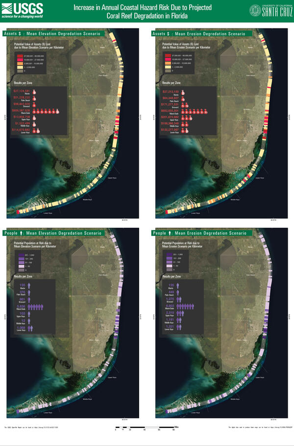
Coastal hazard risk increase due to reef degradation: Florida
Coastal hazard risk increase due to reef degradation: FloridaFour scenarios for the southern part of the Florida coastline show the increase in annual coastal hazard risk due to projected coral reef degradation.
Coastal hazard risk increase due to reef degradation: Florida
Coastal hazard risk increase due to reef degradation: FloridaFour scenarios for the southern part of the Florida coastline show the increase in annual coastal hazard risk due to projected coral reef degradation.

Future Flooding Impacts from Projected Coral Reef Degradation in FL, 1
Future Flooding Impacts from Projected Coral Reef Degradation in FL, 1Report Summary
Future Flooding Impacts from Projected Coral Reef Degradation in Florida
Projected future degradation of reef natural infrastructure puts U.S. people and property at significant risk of future flooding.
Key Points

Future Flooding Impacts from Projected Coral Reef Degradation in FL, 2
Future Flooding Impacts from Projected Coral Reef Degradation in FL, 2Future flooding on Florida’s reef-lined coasts would increase by 16% if present reef loss continues.
Future Flooding Impacts from Projected Coral Reef Degradation in FL, 2
Future Flooding Impacts from Projected Coral Reef Degradation in FL, 2Future flooding on Florida’s reef-lined coasts would increase by 16% if present reef loss continues.