
Scour under a bridge on the Kenai Peninsula in 2002.
Images
Explore our planet through photography and imagery, including climate change and water all the way back to the 1800s when the USGS was surveying the country by horse and buggy.
Filter Total Items: 21545

Scour under a bridge on the Kenai Peninsula
Scour under a bridge on the Kenai Peninsula in 2002.

Set-up to Sieve Samples for Pollen, Pollen Laboratory
Seen in this image is the sieving setup of the pollen lab.
Seen in this image is the sieving setup of the pollen lab.

Sieving a Sample to Extract Pollen, Pollen Laboratory
In this photo, a lab technician sieves a sample to get rid of fine minerals (such as clay).
In this photo, a lab technician sieves a sample to get rid of fine minerals (such as clay).

Swirling a Sample to Separate Pollen from Minerals, Pollen Laboratory
In a watch glass, a lab technician swirls out pollen from heavier mineral material and then pipets it out.
In a watch glass, a lab technician swirls out pollen from heavier mineral material and then pipets it out.

Measuring streamflow from a cableway, Green River blw Fontenelle Resv
Measuring streamflow from a cableway using an ADCP, Green River blw Fontenelle Reservoir, WY
Measuring streamflow from a cableway using an ADCP, Green River blw Fontenelle Reservoir, WY

Interpretive signage for USGS Western Fisheries Research Center Pump House
Interpretive signage created by interpretive designer and illustrator Denise Dahn, with murals of USGS Western Fisheries Research Center Pump House created by Jeff Jacobson in background.
Interpretive signage created by interpretive designer and illustrator Denise Dahn, with murals of USGS Western Fisheries Research Center Pump House created by Jeff Jacobson in background.

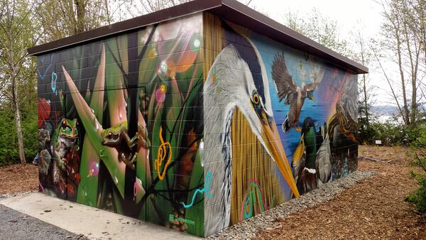
Murals on the USGS Western Fisheries Research Center Pump House
Murals on the USGS Western Fisheries Research Center Pump House structure by Jeff Jacobson.
Murals on the USGS Western Fisheries Research Center Pump House structure by Jeff Jacobson.
USGS Western Fisheries Research Structure Pump House structure
Murals on the USGS Western Fisheries Research Structure Pump House structure by Jeff Jacobson.
Murals on the USGS Western Fisheries Research Structure Pump House structure by Jeff Jacobson.

Beaufort Sea Ice Experiences Unusually Early Breakup
Ice covering Beaufort Sea near the Arctic Ocean typically reaches full-blown breakup by late May each year as air and water temperatures warm, and as daylight turns longer. But 2016 has been dramatically different.
Ice covering Beaufort Sea near the Arctic Ocean typically reaches full-blown breakup by late May each year as air and water temperatures warm, and as daylight turns longer. But 2016 has been dramatically different.

DDT nearly wiped out these birds, now they’re making a comeback
Washington Post article on the impacts of DDT on birds.
Washington Post article on the impacts of DDT on birds.

Salt Creek Rock Avalanche in Western Colorado
Photograph taken from a Colorado National Guard helicopter looking north down the West Salt Creek rock avalanche deposit. On May 25, 2014, the central core of the rock avalanche deposit continued to move for 1-2 hours after the main rock avalanche deposit had stopped moving.
Photograph taken from a Colorado National Guard helicopter looking north down the West Salt Creek rock avalanche deposit. On May 25, 2014, the central core of the rock avalanche deposit continued to move for 1-2 hours after the main rock avalanche deposit had stopped moving.

Beach erosion, North Carolina, 2011, caused by Hurricane Irene.
Oblique aerial photograph near Rodanthe, NC, along the coast on August 30, 2011, three days after landfall of Hurricane Irene. A breach was carved through the barrier island, severing NC Highway 12. The storm surge was approximately 2 m high on the sound-side and was less on the ocean-side.
Oblique aerial photograph near Rodanthe, NC, along the coast on August 30, 2011, three days after landfall of Hurricane Irene. A breach was carved through the barrier island, severing NC Highway 12. The storm surge was approximately 2 m high on the sound-side and was less on the ocean-side.

Eudialyte and Bastnäsite Samples
Sample of eudialyte (pink) within layered vein consisting of quartz, albite, and sodic amphibole, Dora Bay, Alaska. Size of sample is 11 by 9 cm. Sample of coarse-grained, tabular bastnäsite within matrix of ferruginous dolomite, Birthday Claim, Mountain Pass, California. Photographs by Philip Verplanck, U.S. Geological Survey. SIR 2010-5070-J
Sample of eudialyte (pink) within layered vein consisting of quartz, albite, and sodic amphibole, Dora Bay, Alaska. Size of sample is 11 by 9 cm. Sample of coarse-grained, tabular bastnäsite within matrix of ferruginous dolomite, Birthday Claim, Mountain Pass, California. Photographs by Philip Verplanck, U.S. Geological Survey. SIR 2010-5070-J

1955 USGS streamgage near Carrollton, Texas
Nearly completed construction of a streamgage structure in 1955 at Elm Fork Trinity River near Carollton, Texas.
Nearly completed construction of a streamgage structure in 1955 at Elm Fork Trinity River near Carollton, Texas.

Construction of a USGS streamgage in 1939
Construction in 1939 of a streamgage structure at Elm Fork Trinity River near Carrollton, Texas.
Construction in 1939 of a streamgage structure at Elm Fork Trinity River near Carrollton, Texas.

Discharge Measurement at Moyer Creek
USGS Hydrologist Travis Smith makes a wading (section-by-section) discharge measurement at Moyer Creek stream gauging station near Frankfort, NY to allow for better estimates of streamflow during ice-affected periods in winter.
USGS Hydrologist Travis Smith makes a wading (section-by-section) discharge measurement at Moyer Creek stream gauging station near Frankfort, NY to allow for better estimates of streamflow during ice-affected periods in winter.

Early USGS streamgage in Dallas, Texas
This 1922 photo shows an early USGS streamgage on the Trinity River in Dallas.
This 1922 photo shows an early USGS streamgage on the Trinity River in Dallas.

Early USGS streamgage in Texas
Looking upstream from gage site at Trinity River at Commerce Street Bridge.
Looking upstream from gage site at Trinity River at Commerce Street Bridge.

Ground-Penetrating Radar acquisition at Fire Island, NY
Ground-Penetrating Radar instruments are towed across land. Data from this instrument show underlying sediment layers within the dune and barrier island, which may reveal patterns of growth and erosion.
Ground-Penetrating Radar instruments are towed across land. Data from this instrument show underlying sediment layers within the dune and barrier island, which may reveal patterns of growth and erosion.

Karyn Rode checking vitals of polar bear on the Chukchi Sea
Karyn Rode taking vitals on a polar bear in the Chukchi Sea April 2016. On sea ice off the northwest coast of Alaska in the Chukchi Sea.
Karyn Rode taking vitals on a polar bear in the Chukchi Sea April 2016. On sea ice off the northwest coast of Alaska in the Chukchi Sea.

Oldest version of a USGS streamgage in Texas
A close-up view of the top part of one of the oldest streamgage structures constructed in Texas.
A close-up view of the top part of one of the oldest streamgage structures constructed in Texas.