
Small plants grow beneath the needles of a Bishop pine
Images
Explore our planet through photography and imagery, including climate change and water all the way back to the 1800s when the USGS was surveying the country by horse and buggy.
Filter Total Items: 21344

Bishop pine acting as a plant nursery
Small plants grow beneath the needles of a Bishop pine

Rainbow over Halema‘uma‘u and the water lake
The KWcam webcam at Kīlauea's summit captured a rainbow over the water lake in Halema‘uma‘u this afternoon, as light mist moved across the caldera.
The KWcam webcam at Kīlauea's summit captured a rainbow over the water lake in Halema‘uma‘u this afternoon, as light mist moved across the caldera.

Return of the Terns
Now that Forster’s terns have returned to nesting in Pond A16, an important nesting colony has been re-established, with hopes that this tern colony will grow in future years and help reverse the decline of the Forster’s tern population in San Francisco Bay.
Now that Forster’s terns have returned to nesting in Pond A16, an important nesting colony has been re-established, with hopes that this tern colony will grow in future years and help reverse the decline of the Forster’s tern population in San Francisco Bay.

USGS Scientists Map Nutrients on Sacramento Delta
USGS Scientists Map Nutrients on Sacramento Delta
USGS Scientists Map Nutrients on Sacramento Delta

Aerial image from post-Hurricane Isaias of North Carolina coast
Aerial image from post-Hurricane Isaias of North Carolina coastThe USGS Remote Sensing Coastal Change Project collected aerial imagery of the northern Outer Banks, North Carolina coastline from pre- and post-Hurricane Isaias, in order to use Structure-from-Motion techniques to produce digital elevation models (DEMs) and orthomosaic photos, to be used in evaluating the storm-induced coastal change, such as sand transported onto

Flooded Pennsylvania Streamgage after Hurricane Isaias
Flooded Pennsylvania Streamgage after Hurricane IsaiasThis USGS streamgage on Schantz Spring near Wescosville, Pennsylvania was partially submerged after floodwaters from Tropical Storm Isaias quickly rose and flooded the area.
Flooded Pennsylvania Streamgage after Hurricane Isaias
Flooded Pennsylvania Streamgage after Hurricane IsaiasThis USGS streamgage on Schantz Spring near Wescosville, Pennsylvania was partially submerged after floodwaters from Tropical Storm Isaias quickly rose and flooded the area.

Measuring streamflow on Rock Creek after Hurricane Isaias
Measuring streamflow on Rock Creek after Hurricane IsaiasFisseha Mengistu, USGS hydrologic technician, uses a device that lowers a water sampler into the creek below to collect samples used for water quality testing. Experts will be able to use this data to track how Tropical Storm Isaias impacted water quality in the area. This work was done on Rock Creek in Washington, D.C.

Aquatic insect sampling in Glacier National Park
Researchers taking aquatic insect samples in a high-elevation Glacier National Park stream as part of ecohydrological monitoring efforts to study the effects of climate change on aquatic species and ecosystems.
Researchers taking aquatic insect samples in a high-elevation Glacier National Park stream as part of ecohydrological monitoring efforts to study the effects of climate change on aquatic species and ecosystems.
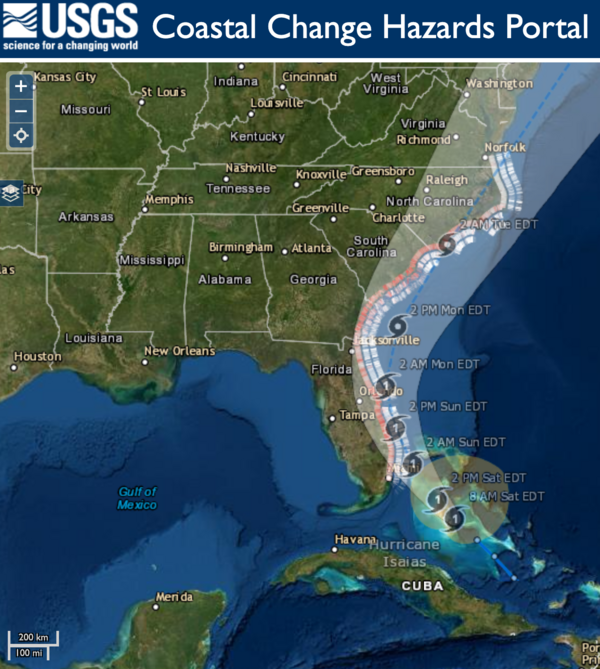
Hurricane Isaias Unlikely to Cause Widespread Atlantic Beach Erosion
Hurricane Isaias Unlikely to Cause Widespread Atlantic Beach ErosionUSGS coastal change experts predict that storm waves kicked up by the Category 1 hurricane are likely to cause some erosion at the base of the dunes along about 11 percent of coastal beaches between Florida and Virginia.

RDG installed in NC to monitor potential flooding caused by Isaias
RDG installed in NC to monitor potential flooding caused by IsaiasThis rapid deployment gauge was installed August 1 in Swansboro, North Carolina on the White Oak River to monitor water levels in order track potential flooding caused by Tropical Storm Isaias. Photo by Bryce McClenney, USGS.
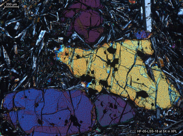
Thin section image of a lava sample from Yellowstone
Thin section image of a lava sample from YellowstoneThin section image of a lava sample from Yellowstone using a polarizing microscope. The mineral assemblage is representative of many of Yellowstone’s basaltic rocks. The three large and colored crystals (known as phenocrysts) in the center of the image are the mineral olivine.

This USGS storm tide sensor installed for Hurricane Isaias.
This USGS storm tide sensor installed for Hurricane Isaias.This USGS storm tide sensor was installed August 1 in North Myrtle Beach, South Carolina to measure the coastal impacts of Hurricane Isaias. Photo by Joshua Lee, USGS.
This USGS storm tide sensor installed for Hurricane Isaias.
This USGS storm tide sensor installed for Hurricane Isaias.This USGS storm tide sensor was installed August 1 in North Myrtle Beach, South Carolina to measure the coastal impacts of Hurricane Isaias. Photo by Joshua Lee, USGS.

Timelapse showing typical activity at Kīlauea's summit water lake
Timelapse showing typical activity at Kīlauea's summit water lakeThis timelapse video at Kīlauea's summit covers approximately 30 minutes and shows the dynamic nature of the water lake in Halema‘uma‘u crater. Steam from the hot water surface is constantly shifting in the winds, while the migrating color boundaries on the water surface appear to show circulation in the lake. USGS video by M. Patrick.

Kīlauea Volcano's summit water lake is one-year old
Kīlauea Volcano's summit water lake is one-year oldPlot showing rise of Kīlauea's summit crater lake over the past year, during which laser rangefinder measurements of lake level were made 2–3 times per week. Photos compare the lake on August 27, 2019, when it was ~22 ft (7 m) deep, to July 7, 2020, when it was ~130 ft (40 m) deep. USGS photos.

Little Pine Lake wells
Groundwater piezometers used to monitor vertical hydraulic gradients, Little Pine Lake, Browns Mills, New Jersey.
Groundwater piezometers used to monitor vertical hydraulic gradients, Little Pine Lake, Browns Mills, New Jersey.

Visitors at Winnewissa Falls viewing area, Pipestone National Monument
Visitors at Winnewissa Falls viewing area, Pipestone National MonumentVisitors at Winnewissa Falls in Pipestone National Monument
Visitors at Winnewissa Falls viewing area, Pipestone National Monument
Visitors at Winnewissa Falls viewing area, Pipestone National MonumentVisitors at Winnewissa Falls in Pipestone National Monument

Continued slow rise of water in Halema‘uma‘u
Kīlauea's summit water lake, in Halema‘uma‘u, continues to slowly rise. Today, the lake colors were vibrant, with a zone of aquamarine water in the west end (lower right in photo). These greenish zones tend to be slightly hotter, and appear to be zones of water influx. USGS photo by M. Patrick.
Kīlauea's summit water lake, in Halema‘uma‘u, continues to slowly rise. Today, the lake colors were vibrant, with a zone of aquamarine water in the west end (lower right in photo). These greenish zones tend to be slightly hotter, and appear to be zones of water influx. USGS photo by M. Patrick.

Jezero crater, Mars
This oblique view looking toward the northwest shows the location where a river valley cuts through the rim of Jezero crater and ends in a fan-shaped delta deposit. The Perseverance Mars rover will land near this delta to search for evidence of past life and collect samples that could be returned to Earth by a later mission.
This oblique view looking toward the northwest shows the location where a river valley cuts through the rim of Jezero crater and ends in a fan-shaped delta deposit. The Perseverance Mars rover will land near this delta to search for evidence of past life and collect samples that could be returned to Earth by a later mission.

Jezero crater, Mars
Description: This is a high-resolution oblique view of the southern edge of the delta deposit in Jezero crater, the landing site for the Perseverance Mars rover. In the foreground, a butte of delta material stands above the crater floor.
Description: This is a high-resolution oblique view of the southern edge of the delta deposit in Jezero crater, the landing site for the Perseverance Mars rover. In the foreground, a butte of delta material stands above the crater floor.

Jezero crater, Mars
Description: This is a high-resolution oblique view of the northeastern edge of the delta deposit in Jezero crater, the landing site for the Perseverance Mars rover. In the foreground, buttes of delta material stand above the crater floor. On the left and in the middle of this image, the layered rocks of the delta deposit are visible.
Description: This is a high-resolution oblique view of the northeastern edge of the delta deposit in Jezero crater, the landing site for the Perseverance Mars rover. In the foreground, buttes of delta material stand above the crater floor. On the left and in the middle of this image, the layered rocks of the delta deposit are visible.

Jezero crater, Mars
Description: This oblique view looks to the west from above the Jezero crater floor, over the fan-shaped delta deposit, and into the valley that cuts through the crater rim. The Perseverance Mars rover will land near this delta to search for evidence of past life and collect samples that could be returned to Earth by a later mission.
Description: This oblique view looks to the west from above the Jezero crater floor, over the fan-shaped delta deposit, and into the valley that cuts through the crater rim. The Perseverance Mars rover will land near this delta to search for evidence of past life and collect samples that could be returned to Earth by a later mission.