U.S. flag

An official website of the United States government

Multimedia

The USGS Volcano Observatories host videos, photos, web camera views, and sometimes podcasts to share visual and audio information about volcanic eruptions and volcanic processes. 

Images

Color photograph of lava fountaining within caldera
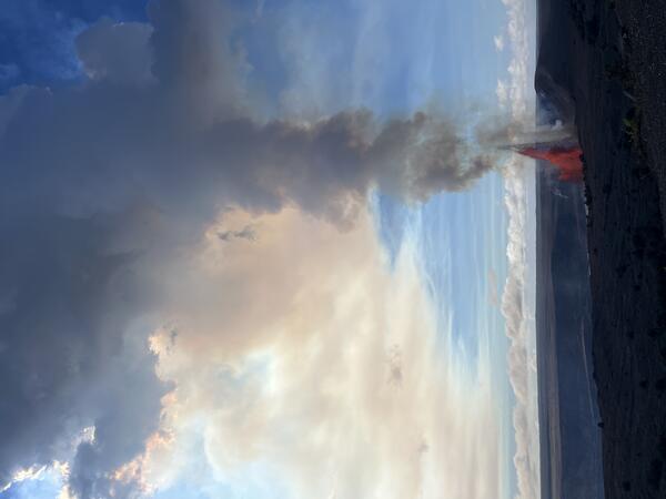
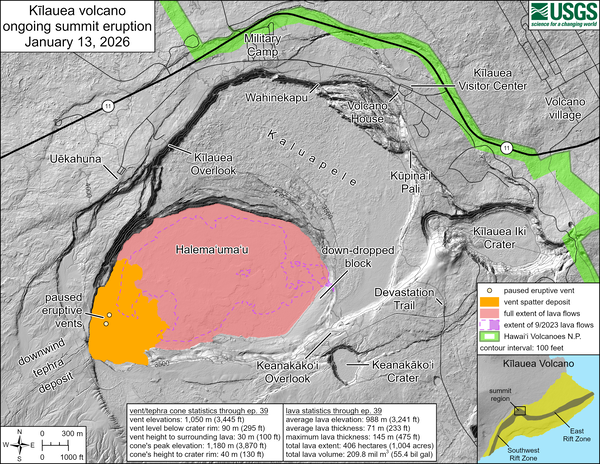
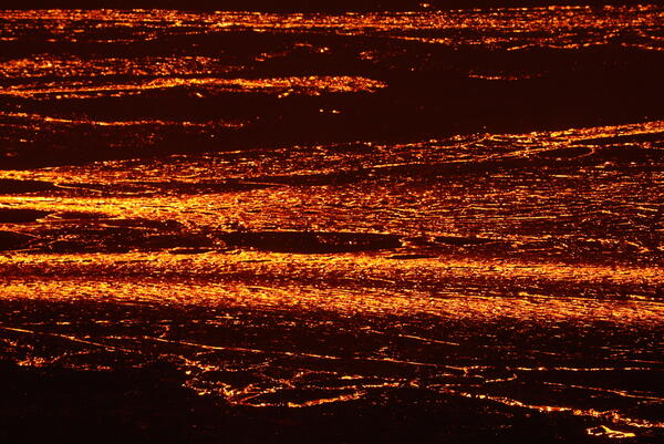
January 12, 2026 — Kīlauea episode 40 from Uēkahuna

On January 12, 2026, Kīlauea had its 40th fountaining episode of the ongoing eruption within Halema‘uma‘u. This view was taken at 10:50 a.m. H.S.T. from the publicly accessible viewing area at Uēkahuna within Hawaiʻi Volcanoes National Park, showing north vent fountaining. USGS photo by N. Deligne. 

On January 12, 2026, Kīlauea had its 40th fountaining episode of the ongoing eruption within Halema‘uma‘u. This view was taken at 10:50 a.m. H.S.T. from the publicly accessible viewing area at Uēkahuna within Hawaiʻi Volcanoes National Park, showing north vent fountaining. USGS photo by N. Deligne. 

Color map showing area recently affected by eruption
January 13, 2026—Kīlauea summit eruption reference map

This reference map depicts the Kīlauea summit eruption within Halema‘uma‘u crater that began on December 23, 2024. The data for this map were collected during a Hawaiian Volcano Observatory helicopter overflight on January 2, 2026; as such, the provided statistics are reflective of the first thirty-nine episodes of the eruption through December 24, 2025.

This reference map depicts the Kīlauea summit eruption within Halema‘uma‘u crater that began on December 23, 2024. The data for this map were collected during a Hawaiian Volcano Observatory helicopter overflight on January 2, 2026; as such, the provided statistics are reflective of the first thirty-nine episodes of the eruption through December 24, 2025.

Color photograph of lava fountaining within a caldera
January 12, 2026 — Kīlauea episode 40 from Kūpinaʻi Pali

On January 12, 2026, Kīlauea had its 40th fountaining episode of the ongoing eruption within Halema‘uma‘u. This photo was taken at 4:37 p.m. HST from the publicly accessible viewing area at Kūpinaʻi Pali (Waldron's Ledge) within Hawaiʻi Volcanoes National Park, showing north vent fountaining. The episode ended about an hour and a half after this photo was taken.

On January 12, 2026, Kīlauea had its 40th fountaining episode of the ongoing eruption within Halema‘uma‘u. This photo was taken at 4:37 p.m. HST from the publicly accessible viewing area at Kūpinaʻi Pali (Waldron's Ledge) within Hawaiʻi Volcanoes National Park, showing north vent fountaining. The episode ended about an hour and a half after this photo was taken.

Color photograph of lava fountaining with crater rim in foreground
January 12, 2026 — Kīlauea episode 40 fountains from Uēkahuna overlook

USGS Hawaiian Volcano Observatory geologists observe episode 40 fountains from the Uēkahuna overlook within Hawai‘i Volcanoes National Park. This episode had multiple days of precursory overflows from both the north and south vents, leading to fountains primarily from the north vent starting on January 12 and reaching up to 800 feet (250 meters).

USGS Hawaiian Volcano Observatory geologists observe episode 40 fountains from the Uēkahuna overlook within Hawai‘i Volcanoes National Park. This episode had multiple days of precursory overflows from both the north and south vents, leading to fountains primarily from the north vent starting on January 12 and reaching up to 800 feet (250 meters).

Telephoto of lava flow
November 25, 2025—Kīlauea summit eruption episode 37 lava flow

The telephoto shows lava flowing east across the floor of Halemaʻumaʻu crater, fed by the lava fountains in the west part of the crater.  Preliminary estimates suggest that approximately 6 million cubic meters (7.8 million cubic yards) of lava were erupted during episode 37, based on ground deformation data. USGS photo by M. Patrick. 

The telephoto shows lava flowing east across the floor of Halemaʻumaʻu crater, fed by the lava fountains in the west part of the crater.  Preliminary estimates suggest that approximately 6 million cubic meters (7.8 million cubic yards) of lava were erupted during episode 37, based on ground deformation data. USGS photo by M. Patrick. 

Map of Yellowstone with colored triangles and boxes showing locations, types, and operators for seismic stations
Yellowstone seismic network

Map of seismic stations in the Yellowstone region, with numbers of channels indicated by number and sensor type by color.  Inverted triangles indicate stations operated by University of Utah Seismograph Stations (UUSS), and squares indicate stations operated by other agencies.

Map of seismic stations in the Yellowstone region, with numbers of channels indicated by number and sensor type by color.  Inverted triangles indicate stations operated by University of Utah Seismograph Stations (UUSS), and squares indicate stations operated by other agencies.

Videos

Thumbnail image of a man speaking in front of a photo of a colorful hot spring Thumbnail image of a man speaking in front of a photo of a colorful hot spring
Top 5 Yellowstone geological stories of 2025 (Yellowstone monthly update - January 2026)

Happy New Year! Let's go back and take a look at the top five geologic stories for Yellowstone in 2025.

Number five: Rumors. It was a year of internet rumors, mostly related to animals fleeing the park, and none of which were true.

Thumbnail image of a man speaking in front of a desolate Yellowstone thermal basin Thumbnail image of a man speaking in front of a desolate Yellowstone thermal basin
Hawaii versus Yellowstone (Yellowstone monthly update - December 2025)

Just last week, Kīlauea put on another dramatic display of lava fountaining and flows within the caldera, during its 37th episode of this most recent eruption. It doesn't seem like Hawaii and Yellowstone have a lot in common, but actually, those two magmatic systems have a common cause.

Just last week, Kīlauea put on another dramatic display of lava fountaining and flows within the caldera, during its 37th episode of this most recent eruption. It doesn't seem like Hawaii and Yellowstone have a lot in common, but actually, those two magmatic systems have a common cause.

Thumbnail image of a man gesturing towards trees in the background Thumbnail image of a man gesturing towards trees in the background
Emergency fix at a Yellowstone monitoring site (Yellowstone Monthly Update October 2025)

The Yellowstone caldera is vast – 45 miles across by 30 miles wide. You could fit over 60 islands of Manhattan in this area. There are deep canyons, like the one on the Yellowstone River, that reveal a complex geologic history. And, forested landscapes and features remind us that this special place is ever-changing.

The Yellowstone caldera is vast – 45 miles across by 30 miles wide. You could fit over 60 islands of Manhattan in this area. There are deep canyons, like the one on the Yellowstone River, that reveal a complex geologic history. And, forested landscapes and features remind us that this special place is ever-changing.

Thumbnail image of a man with his arms in the air in a meadow with cliffs in the background Thumbnail image of a man with his arms in the air in a meadow with cliffs in the background
Lava flows in Yellowstone! (Yellowstone Monthly Update September 2025)

Picture a Yellowstone eruption. What comes to mind? It’s a huge explosion, right? Like the one that formed the caldera about 631,000 years ago. But the most common form of eruption in Yellowstone isn’t a huge explosion, it’s a lava flow.

Picture a Yellowstone eruption. What comes to mind? It’s a huge explosion, right? Like the one that formed the caldera about 631,000 years ago. But the most common form of eruption in Yellowstone isn’t a huge explosion, it’s a lava flow.

Color photograph of lava pond in volcanic vent Color photograph of lava pond in volcanic vent
August 5, 2025 — Lava flowing in the north vent

During a USGS Hawaiian Volcano Observatory helicopter overflight on the morning of August 5, geologists observed a lava pond within the north vent of the ongoing Kīlauea summit eruption. The pond was feeding a subterranean lava tube contained within the east side of the vent cone, toward the floor of Halema‘uma‘u crater.

During a USGS Hawaiian Volcano Observatory helicopter overflight on the morning of August 5, geologists observed a lava pond within the north vent of the ongoing Kīlauea summit eruption. The pond was feeding a subterranean lava tube contained within the east side of the vent cone, toward the floor of Halema‘uma‘u crater.

Rainier seismic swarm update - July 14, 2025

In this video, Cascades Volcano Observatory (CVO) scientists Tyler Paladino and Alex Iezzi and Mount Rainier National Park Geologist Scott Beason provide an update on the earthquake swarm at Mount Rainier.

In this video, Cascades Volcano Observatory (CVO) scientists Tyler Paladino and Alex Iezzi and Mount Rainier National Park Geologist Scott Beason provide an update on the earthquake swarm at Mount Rainier.

Audio

Kīlauea's Summit Vent Churns and Pops as Rocks Fall Into the Lava L...
Kīlauea's Summit Vent Churns and Pops as Rocks Fall Into Lava Lake
Lava lake activity from inside Halema`uma`u Crater
Kīlauea's Summit Vent Churns and Pops as Rocks Fall Into the Lava L...
Kīlauea's Summit Vent Churns and Pops as Rocks Fall Into Lava Lake
Lava lake activity from inside Halema`uma`u Crater

Sounds of lava lake activity within Kilauea Volcano's summit vent inside Halema`uma`u Crater on the afternoon of February 14, 2011. The continuous "crashing wave" noise is the sound of churning lava as gases are released from the lake surface, which is in nearly constant motion.

Sounds of lava lake activity within Kilauea Volcano's summit vent inside Halema`uma`u Crater on the afternoon of February 14, 2011. The continuous "crashing wave" noise is the sound of churning lava as gases are released from the lake surface, which is in nearly constant motion.

CoreFacts
CoreFacts Album Artwork
How far did the ash from Mount St. Helens travel?
CoreFacts
CoreFacts Album Artwork
How far did the ash from Mount St. Helens travel?

Welcome to CoreFacts, where we're always short on time and big on science. I'm Brian Campbell. Today's question is …

How far did the ash from Mount St. Helens travel?

Welcome to CoreFacts, where we're always short on time and big on science. I'm Brian Campbell. Today's question is …

How far did the ash from Mount St. Helens travel?

USGS CoreCast
USGS CoreCast Series
Dramatic Developments at Kilauea Volcano
USGS CoreCast
USGS CoreCast Series
Dramatic Developments at Kilauea Volcano

Kilauea Volcano in Hawaii has experienced its first explosive eruption in more than 80 years and is now spewing noxious gas at 10 times the normal rate. John Eichelberger, head of the USGS Volcano Hazards Program, fills us in on the situation.

Kilauea Volcano in Hawaii has experienced its first explosive eruption in more than 80 years and is now spewing noxious gas at 10 times the normal rate. John Eichelberger, head of the USGS Volcano Hazards Program, fills us in on the situation.

Webcams

Looking at hot spring with high cliffs in the background
Biscuit Basin webcam

The camera view is north-northwest from the Biscuit Basin boardwalk looking at Black Diamond Pool, which is in the foreground (the tilted viewing angle is due to the slope of the boardwalk).

The camera view is north-northwest from the Biscuit Basin boardwalk looking at Black Diamond Pool, which is in the foreground (the tilted viewing angle is due to the slope of the boardwalk).

Image of Mount St. Helens looking south from north of the volcano
Johnston Ridge Observatory, Mount St. Helens

This static image is from a USGS Cascades Volcano Observatory research camera located at the Johnston Ridge Observatory, north of Mount St. Helens.  The view is to the south.  This camera is intended to assist the USGS with situational awareness. At times, clouds, rain, and snow obscure visibility.

This static image is from a USGS Cascades Volcano Observatory research camera located at the Johnston Ridge Observatory, north of Mount St. Helens.  The view is to the south.  This camera is intended to assist the USGS with situational awareness. At times, clouds, rain, and snow obscure visibility.

Webcam image view of volcano flank
[HLcam] Live Image of Mauna Loa's northwest flank from Hualālai volcano
[HLcam] Live Image of Mauna Loa's northwest flank from Hualālai volcano
[HLcam] Live Image of Mauna Loa's northwest flank from Hualālai volcano

Live view of the northwest flank of Mauna Loa; the view is from the southeast flank of Hualālai [HLcam]. This camera is a pan-tilt-zoom model and the view may change depending on activity.

Live webcam view of lava erupting from Mauna Loa volcano
[MK2cam] Mauna Loa's Summit and Northeast Rift Zone from Mauna Kea
[MK2cam] Mauna Loa's Summit and Northeast Rift Zone from Mauna Kea
[MK2cam] Mauna Loa's Summit and Northeast Rift Zone from Mauna Kea

Live Image of Mauna Loa's Summit and Northeast Rift Zone from Mauna Kea [MK2cam]. This camera is a pan-tilt-zoom model and the view may change depending on activity.

Webcam image view of volcanic vent in summit crater
[V1cam] Kīlauea volcano, Hawaii (west Halemaʻumaʻu crater)
[V1cam] Kīlauea volcano, Hawaii (west Halemaʻumaʻu crater)
[V1cam] Kīlauea volcano, Hawaii (west Halemaʻumaʻu crater)

Live view of Halemaʻumaʻu crater within Kaluapele (Kīlauea caldera), from the northwest rim of the crater [V1cam]. This camera is a pan-tilt-zoom model and the view may change depending on activity.

Disclaimer

Live view of Halemaʻumaʻu crater within Kaluapele (Kīlauea caldera), from the northwest rim of the crater [V1cam]. This camera is a pan-tilt-zoom model and the view may change depending on activity.

Disclaimer

This image is from a temporary research camera positioned just south of Puʻu ʻŌʻō, looking north at the southern flank of Puʻ
[PScam] Puʻu ʻŌʻō South Flank from the South Rim
[PScam] Puʻu ʻŌʻō South Flank from the South Rim
[PScam] Puʻu ʻŌʻō South Flank from the South Rim

This image is from a temporary research camera positioned just south of Puʻu ʻŌʻō, looking north at the southern flank of Puʻu ʻŌʻō's cone.


Disclaimer

Was this page helpful?