
Images
Explore photos, graphics, and illustrations related to projects from across the CASC Network. And be sure to check out our Climate Illustrations page, featuring free-to-download illustrations that help describe tricky climate concepts and explain how climate change affects the world around us.


Plants Vulnerability to Nitrogen Depends on Where They Grow
Plants Vulnerability to Nitrogen Depends on Where They GrowA subalpine meadow on Niwot Ridge, Colorado, displaying a rich diversity of plants.
Plants Vulnerability to Nitrogen Depends on Where They Grow
Plants Vulnerability to Nitrogen Depends on Where They GrowA subalpine meadow on Niwot Ridge, Colorado, displaying a rich diversity of plants.

Field camp in the Yukon-Kuskokwim Delta, western AK
Field camp in the Yukon-Kuskokwim Delta, western AKField camp in the Yukon-Kuskokwim Delta, western AK, where USGS and other ecologists monitor impacts of climate changes, erosion, sedimentation, and flooding on coastal ecosystems
Field camp in the Yukon-Kuskokwim Delta, western AK
Field camp in the Yukon-Kuskokwim Delta, western AKField camp in the Yukon-Kuskokwim Delta, western AK, where USGS and other ecologists monitor impacts of climate changes, erosion, sedimentation, and flooding on coastal ecosystems

An Alaska Native village on the Yukon-Kuskokwim Delta, western AK
An Alaska Native village on the Yukon-Kuskokwim Delta, western AKAn Alaska Native village on the Yukon-Kuskokwim Delta, western AK
An Alaska Native village on the Yukon-Kuskokwim Delta, western AK
An Alaska Native village on the Yukon-Kuskokwim Delta, western AKAn Alaska Native village on the Yukon-Kuskokwim Delta, western AK

Wind Cave is the first cave national park and currently, the 6th most extensive cave network in the world. It's most famous for its large concentration of a fairly rare cave formation known as boxwork. Boxwork is formed when dissolved calcium carbonate crystallized in cracks in surrounding rock.
Wind Cave is the first cave national park and currently, the 6th most extensive cave network in the world. It's most famous for its large concentration of a fairly rare cave formation known as boxwork. Boxwork is formed when dissolved calcium carbonate crystallized in cracks in surrounding rock.

Scenic view from Siuslaw National Forest, OR.

This is a photograph of the Las Conchas Fire, USGS - New Mexico Water Science Center
This is a photograph of the Las Conchas Fire, USGS - New Mexico Water Science Center

Salt marsh grass grows in the restored marsh at Bass Creek, Yarmouth, MA.
Salt marsh grass grows in the restored marsh at Bass Creek, Yarmouth, MA.

Photograph showing San Pedro Riparian National Conservation Area, residential development southeast of Sierra Vista, Arizona, and the Huachuca Mountains from Hereford Road, Cochise County, Arizona.
Photograph showing San Pedro Riparian National Conservation Area, residential development southeast of Sierra Vista, Arizona, and the Huachuca Mountains from Hereford Road, Cochise County, Arizona.
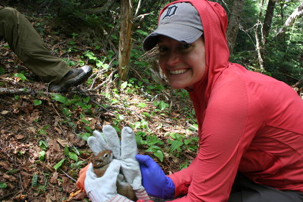
Toni Lyn Morelli; White Mountain National Forest, NH; trapping red squirrels
Toni Lyn Morelli; White Mountain National Forest, NH; trapping red squirrels

Douglas-fir trees topped to create snags for wildlife habitat
Douglas-fir trees topped to create snags for wildlife habitatSnags provide habitat for a wide range of organisms from cavity-nesting birds to insects, and are critical for maintaining forest biodiversity. Resource managers can create snags by topping trees to mitigate loss of snags to timber harvest, but information regarding changes in habitat for snag-dependent wildlife over time as created snags decay is lacking.

Coral reefs, Kwajalein Atoll, Republic of the Marshall Islands
Coral reefs, Kwajalein Atoll, Republic of the Marshall IslandsAerial photograph of Kwajalein Atoll showing its low-lying islands and coral reefs.
Coral reefs, Kwajalein Atoll, Republic of the Marshall Islands
Coral reefs, Kwajalein Atoll, Republic of the Marshall IslandsAerial photograph of Kwajalein Atoll showing its low-lying islands and coral reefs.

Coral reefs, Kwajalein Atoll, Republic of the Marshall Islands
Coral reefs, Kwajalein Atoll, Republic of the Marshall IslandsUnderwater image of a wave breaking over a coral reef on Kwajalein Atoll in the Republic of the Marshall Islands. This image shows how the high hydrodynamic roughness of live, healthy corals causes friction that induces breaking of waves over coral reefs, reducing wave energy at the shoreline that can cause flooding and island overwash.

Coral reefs, Kwajalein Atoll, Republic of the Marshall Islands
Coral reefs, Kwajalein Atoll, Republic of the Marshall IslandsAerial photograph of Kwajalein Atoll showing its low-lying islands and coral reefs.
Coral reefs, Kwajalein Atoll, Republic of the Marshall Islands
Coral reefs, Kwajalein Atoll, Republic of the Marshall IslandsAerial photograph of Kwajalein Atoll showing its low-lying islands and coral reefs.

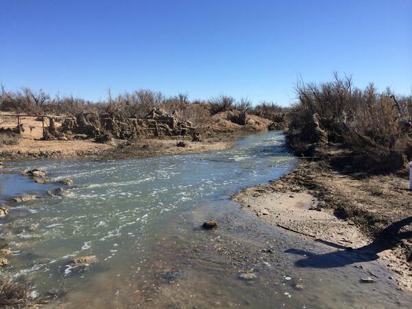
Devils River - downstream view. Pecos River Watershed Salinity Study. April 14-16, 2015 field trip, Texas.
Devils River - downstream view. Pecos River Watershed Salinity Study. April 14-16, 2015 field trip, Texas.
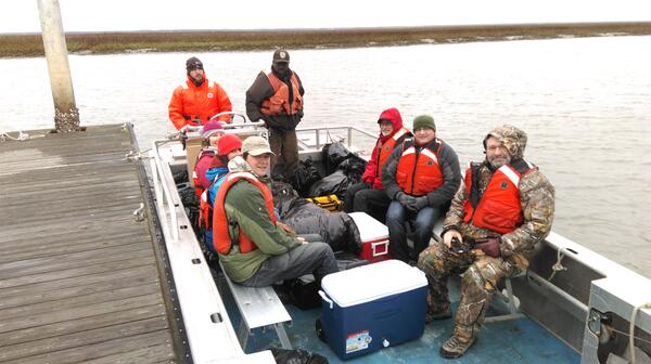
FWS staff leading a tour of the coastal marshes of Cape Romain NWR
FWS staff leading a tour of the coastal marshes of Cape Romain NWRFWS staff leading a tour of the coastal marshes of Cape Romain NWR. Project team members (clockwise starting at 1pm) included Fred Johnson, Nathan Wood, David Case, Julien Martin, Elda Varela Minder, and Jennifer Costanza. (credit – M. Eaton)
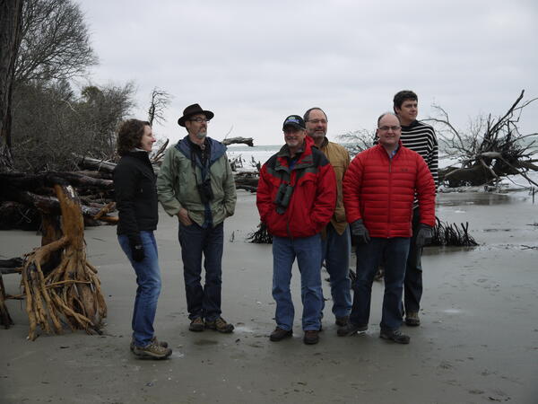
Cape Romain Project team members visit 'boneyard beach'
Cape Romain Project team members visit 'boneyard beach'Cape Romain Project team members (left to right) Jen Costanza, Mitch Eaton, Fred Johnson, Dave Case, Nate Wood and Julien Martin visit the refuge’s ‘boneyard beach’ to observe the impacts of SLR on former maritime forest. (credit - M. Eaton)
Pecos River at Old Crane Road bridge, Texas, downstream view. Photograph by Christopher Braun, U.S. Geological Survey, February 2015.
SIR 2019-5071
Pecos River at Old Crane Road bridge, Texas, downstream view. Photograph by Christopher Braun, U.S. Geological Survey, February 2015.
SIR 2019-5071

Bison herd grazing on a hill in Montana. Ryan Hagerty photo. FWS.
Bison herd grazing on a hill in Montana. Ryan Hagerty photo. FWS.

An amphitheater at the natural entrance of Carlsbad Caverns.
An amphitheater at the natural entrance of Carlsbad Caverns.

Amistad National Recreation Area includes the Amistad Reservoir, a man-made lake along the border of Texas and Mexico.
Amistad National Recreation Area includes the Amistad Reservoir, a man-made lake along the border of Texas and Mexico.