Shallow Water Irradience Platform placement in Barnegat Bay, NJ
Shallow Water Irradience Platform placement in Barnegat Bay, NJInvestigators prepare to place a Shallow Water Irradience Platform (SWIP) at a site in Barnegat Bay, NJ.

Official websites use .gov
A .gov website belongs to an official government organization in the United States.
Secure .gov websites use HTTPS
A lock () or https:// means you’ve safely connected to the .gov website. Share sensitive information only on official, secure websites.
Coastal and Marine Hazards and Resources Program images.
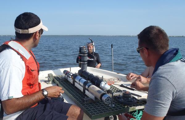
Investigators prepare to place a Shallow Water Irradience Platform (SWIP) at a site in Barnegat Bay, NJ.
Investigators prepare to place a Shallow Water Irradience Platform (SWIP) at a site in Barnegat Bay, NJ.

USGS research supports wetland conservation as critical habitat, Cape Cod, MA
USGS research supports wetland conservation as critical habitat, Cape Cod, MA

USGS and Summer Interns from the Partnership Education Program (PEP) program sampling over a tidal cycle.
USGS and Summer Interns from the Partnership Education Program (PEP) program sampling over a tidal cycle.

Equipment used for a measuring lateral fluxes over tidal cycle
Equipment used for a measuring lateral fluxes over tidal cycle

Estuarine salt marsh at China Camp State Park looking towards San Pablo Bay, northern San Francisco, California.
Estuarine salt marsh at China Camp State Park looking towards San Pablo Bay, northern San Francisco, California.

A sensor is deployed to measure flow in a channel of the marsh in Rachel Carlson National Wildlife Refuge in 2013.
A sensor is deployed to measure flow in a channel of the marsh in Rachel Carlson National Wildlife Refuge in 2013.

Images of the remotely operated vehicle Jason2 sampling a sea urchin in a deep sea mussel community found near a gas seep on the U.S. outer continental shelf. Images courtesy Deepwater Canyons 2013 - Pathways to the Abyss expedition, NOAA-OER/BOEM/USGS.
Images of the remotely operated vehicle Jason2 sampling a sea urchin in a deep sea mussel community found near a gas seep on the U.S. outer continental shelf. Images courtesy Deepwater Canyons 2013 - Pathways to the Abyss expedition, NOAA-OER/BOEM/USGS.

Methane gas bubbles rise from the seafloor—this type of activity, originally noticed by NOAA Ship Okeanos Explorer in 2012 on a multibeam sonar survey, is what led scientists to the area. Image courtesy of Deepwater Canyons 2013 – Pathways to the Abyss expedition, NOAA-OER/BOEM/USGS.
Methane gas bubbles rise from the seafloor—this type of activity, originally noticed by NOAA Ship Okeanos Explorer in 2012 on a multibeam sonar survey, is what led scientists to the area. Image courtesy of Deepwater Canyons 2013 – Pathways to the Abyss expedition, NOAA-OER/BOEM/USGS.

A lithodid crab seen on a bed of deep sea mussels living near a gas seep 1,600 meters below the surface of the Atlantic Ocean. Images courtesy Deepwater Canyons 2013 - Pathways to the Abyss expedition, NOAA-OER/BOEM/USGS.
A lithodid crab seen on a bed of deep sea mussels living near a gas seep 1,600 meters below the surface of the Atlantic Ocean. Images courtesy Deepwater Canyons 2013 - Pathways to the Abyss expedition, NOAA-OER/BOEM/USGS.

Adrian Mann is using a piezometer to extract submarine groundwater to analyze for geochemical parameters in Indian River Bay, DE.
Adrian Mann is using a piezometer to extract submarine groundwater to analyze for geochemical parameters in Indian River Bay, DE.

Assessing how storms move sediment during storms provides coastal scientists and managers the information they need to keep coastal communities safe and prosperous. And, lucky for us, provides many opportunities to see great coastal sunsets!
Assessing how storms move sediment during storms provides coastal scientists and managers the information they need to keep coastal communities safe and prosperous. And, lucky for us, provides many opportunities to see great coastal sunsets!

The San Clemente Dam, built in the 1920s on the Carmel River in Monterey County, California, was removed during 2014 and 2015.
The San Clemente Dam, built in the 1920s on the Carmel River in Monterey County, California, was removed during 2014 and 2015.

Hurricane Sandy moved a house from barrier island to estuary, in this case into Barnegat Bay, NJ. Waves from extreme storms do the same with barrier island sediment.
Hurricane Sandy moved a house from barrier island to estuary, in this case into Barnegat Bay, NJ. Waves from extreme storms do the same with barrier island sediment.

Debris from Hurricane Sandy (Seaside Heights, NJ) is piled up behind an artificial dune in order to protect island infrastructure from the subsequent winter storm season. Like storms, humans change coasts too.
Debris from Hurricane Sandy (Seaside Heights, NJ) is piled up behind an artificial dune in order to protect island infrastructure from the subsequent winter storm season. Like storms, humans change coasts too.

Surveying A Barrier Island Evolution Research (BIER) program study site in the Chandeleur Islands in 2013. The survey data is used to map the pre-storm conditions.
Surveying A Barrier Island Evolution Research (BIER) program study site in the Chandeleur Islands in 2013. The survey data is used to map the pre-storm conditions.

USGS Graduate Research Assistant Legna Torres-Garcia installs a temperature logger on a coral reef in Dry Tortugas National Park. She and her team deployed a vertical array with temperature loggers every 1m from the seabed to near-surface with the goal to capture any changes in temperature through time and across depth.
USGS Graduate Research Assistant Legna Torres-Garcia installs a temperature logger on a coral reef in Dry Tortugas National Park. She and her team deployed a vertical array with temperature loggers every 1m from the seabed to near-surface with the goal to capture any changes in temperature through time and across depth.

Drone footage taken of the Woods Hole Oceanographic facility on the Quissett campus in Woods Hole Ma. This is an example of a tidally restricted marsh system cutoff from tidal flows by the bike path.
Drone footage taken of the Woods Hole Oceanographic facility on the Quissett campus in Woods Hole Ma. This is an example of a tidally restricted marsh system cutoff from tidal flows by the bike path.

Trunk River is an example of a tidally restricted impounded wetland (Cape Cod, MA).
Trunk River is an example of a tidally restricted impounded wetland (Cape Cod, MA).

A red crab trying to crack open a seep mussel, seen during the Deepwater Canyons 2012 Expedition.
A red crab trying to crack open a seep mussel, seen during the Deepwater Canyons 2012 Expedition.

Sarah Sonsthagen (left) drives a skiff as Tony Fischbach scans the ice for resting walruses to radio-tag. On an hourly basis, these instruments show whether the walrus is in the water, resting out of the water, or foraging at the seafloor. The radio tag will fall off after 3 to 12 weeks.
Sarah Sonsthagen (left) drives a skiff as Tony Fischbach scans the ice for resting walruses to radio-tag. On an hourly basis, these instruments show whether the walrus is in the water, resting out of the water, or foraging at the seafloor. The radio tag will fall off after 3 to 12 weeks.
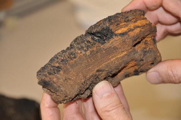
Subsample from dredge DR2-001, collected as a part of the U.S. Extended Continental Shelf Project's research in the Arctic aboard the USCGC Healy on cruise HLY1202 (Field Activity 2012-038-FA).
Subsample from dredge DR2-001, collected as a part of the U.S. Extended Continental Shelf Project's research in the Arctic aboard the USCGC Healy on cruise HLY1202 (Field Activity 2012-038-FA).