This Landsat 8 image "Ice Vortex" is one of many beautiful images in the Earth as Art collections.
Visit https://eros.usgs.gov/media-gallery/earth-as-art to see more.

Official websites use .gov
A .gov website belongs to an official government organization in the United States.
Secure .gov websites use HTTPS
A lock () or https:// means you’ve safely connected to the .gov website. Share sensitive information only on official, secure websites.
The National Land Imaging Program supports a variety of geospatial data programs and projects, including the USGS Landsat Program. Browse the images below to see some of the imagery produced using NLI-supported data sources.

This Landsat 8 image "Ice Vortex" is one of many beautiful images in the Earth as Art collections.
Visit https://eros.usgs.gov/media-gallery/earth-as-art to see more.
This Landsat 8 image "Ice Vortex" is one of many beautiful images in the Earth as Art collections.
Visit https://eros.usgs.gov/media-gallery/earth-as-art to see more.

This Landsat 8 image "Australian Iron Ore" is one of many beautiful images in the Earth as Art collections.
Visit https://eros.usgs.gov/media-gallery/earth-as-art to see more.
This Landsat 8 image "Australian Iron Ore" is one of many beautiful images in the Earth as Art collections.
Visit https://eros.usgs.gov/media-gallery/earth-as-art to see more.

Satellites have captured views of the numerous major fires burning in California.
Satellites have captured views of the numerous major fires burning in California.

Chesapeake Bay is the Nation's largest estuary and its restoration and protection is a priority. The USGS provides scientific information to help manage this vital ecosystem. As part of that role, staff at the USGS Earth Resources Observation and Science (EROS) Center created this true color composite image.
Chesapeake Bay is the Nation's largest estuary and its restoration and protection is a priority. The USGS provides scientific information to help manage this vital ecosystem. As part of that role, staff at the USGS Earth Resources Observation and Science (EROS) Center created this true color composite image.

Center pivot irrigation fields in the Arabian Desert are visible in this Landsat 8 image near Meegowa, Saudi Arabia. The image was acquired on Oct 10, 2018 and is shown in a color infrared band combination (Bands 5,4,3).
Center pivot irrigation fields in the Arabian Desert are visible in this Landsat 8 image near Meegowa, Saudi Arabia. The image was acquired on Oct 10, 2018 and is shown in a color infrared band combination (Bands 5,4,3).
Landsat 8 image - Earth as Art "Tapestry"
View the entire image at https://eros.usgs.gov/media-gallery/earth-as-art/5/tapestry
Landsat 8 image - Earth as Art "Tapestry"
View the entire image at https://eros.usgs.gov/media-gallery/earth-as-art/5/tapestry

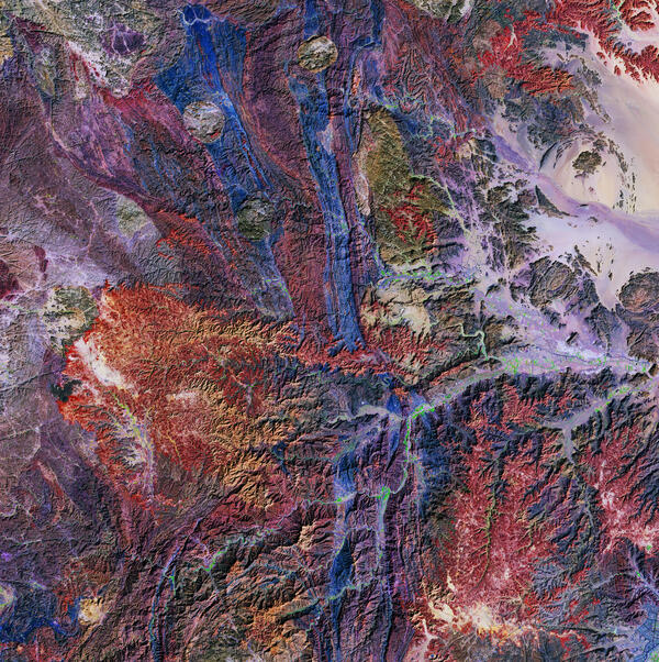
This image titled "Bleeding Heart" is one of many contained in the 5th Earth as Art collection.
Visit https://eros.usgs.gov/media-gallery/earth-as-art to view the entire group of Earth as Art collections.
This image titled "Bleeding Heart" is one of many contained in the 5th Earth as Art collection.
Visit https://eros.usgs.gov/media-gallery/earth-as-art to view the entire group of Earth as Art collections.

A FireFLY6 Pro vertical takeoff and landing (VTOL) fixed-wing UAS sits on the ground between flights at the Corral Bluffs study area to support fossil studies by the Denver Museum of Nature & Science.
A FireFLY6 Pro vertical takeoff and landing (VTOL) fixed-wing UAS sits on the ground between flights at the Corral Bluffs study area to support fossil studies by the Denver Museum of Nature & Science.

Hurricane Florence hit the Carolina coast on September 14, 2018, but it took much longer for the full impact to emerge.
Hurricane Florence hit the Carolina coast on September 14, 2018, but it took much longer for the full impact to emerge.

October 16, 2018, marks the two-year anniversary of the Cottonwood Fire in western South Dakota. The fire consumed a large swath of grassland near the community of Wall and just north of Badlands National Park.
October 16, 2018, marks the two-year anniversary of the Cottonwood Fire in western South Dakota. The fire consumed a large swath of grassland near the community of Wall and just north of Badlands National Park.

Mountain pine beetles are about the size of a grain of rice, so of course we can’t see them from space in satellite images. What is visible is what the beetles can do to a pine forest. The washed-out pink color indicates large areas of standing dead or damaged trees.
Mountain pine beetles are about the size of a grain of rice, so of course we can’t see them from space in satellite images. What is visible is what the beetles can do to a pine forest. The washed-out pink color indicates large areas of standing dead or damaged trees.

Citation: Citation_Information: Originator: U.S.
Citation: Citation_Information: Originator: U.S.

Burning Man is named for the wooden effigy set ablaze at the end of the weeklong celebration in the temporary metropolis of Black Rock City.
Burning Man is named for the wooden effigy set ablaze at the end of the weeklong celebration in the temporary metropolis of Black Rock City.

A total solar eclipse darkened the skies over the United States on Aug. 21, 2017.
Oshkosh, a town in the Nebraska Sandhills, was a prime location for viewing the eclipse. This Landsat 7 image shows the town at 11:33 a.m. local time on Aug. 18, 2016, a year before the total eclipse.
A total solar eclipse darkened the skies over the United States on Aug. 21, 2017.
Oshkosh, a town in the Nebraska Sandhills, was a prime location for viewing the eclipse. This Landsat 7 image shows the town at 11:33 a.m. local time on Aug. 18, 2016, a year before the total eclipse.

Landsat 8 captured satellite views of California's largest wildfire on record in the summer of 2018. The Mendocino Complex fire in northern California is a combination of two fires: the Ranch Fire and the River Fire.
Landsat 8 captured satellite views of California's largest wildfire on record in the summer of 2018. The Mendocino Complex fire in northern California is a combination of two fires: the Ranch Fire and the River Fire.

Many lakes in South Dakota's Prairie Pothole Region are expanding. Lake Thompson in eastern South Dakota is one that has displayed remarkable change in recent decades.
Many lakes in South Dakota's Prairie Pothole Region are expanding. Lake Thompson in eastern South Dakota is one that has displayed remarkable change in recent decades.

The Landsat archive has added its 8 millionth scene. This stunning image was captured by Landsat 8 on July 28, 2018. It shows the coastline of Nordaustlandet, the second-largest island in Norway’s Svalbard archipelago.
The Landsat archive has added its 8 millionth scene. This stunning image was captured by Landsat 8 on July 28, 2018. It shows the coastline of Nordaustlandet, the second-largest island in Norway’s Svalbard archipelago.

Torrential rainfall swamped western Japan in July of 2018. The rain caused mudslides that flooded cities, damaged buildings and rattled the nation’s infrastructure.
Torrential rainfall swamped western Japan in July of 2018. The rain caused mudslides that flooded cities, damaged buildings and rattled the nation’s infrastructure.

Landsat sensor technology has come a long way since the days of the Return Beam Vidicon cameras on the first three Landsat satellites. Known as the RBV, it was originally intended to be the satellites’ primary sensor. But the Multispectral Scanner, or MSS, became the more stable and superior instrument.
Landsat sensor technology has come a long way since the days of the Return Beam Vidicon cameras on the first three Landsat satellites. Known as the RBV, it was originally intended to be the satellites’ primary sensor. But the Multispectral Scanner, or MSS, became the more stable and superior instrument.

This image showing the Black Hills and Badlands, South Dakota is a mosaic of multiple Landsat 8 scenes acquired in 2015 and 2016.
This image showing the Black Hills and Badlands, South Dakota is a mosaic of multiple Landsat 8 scenes acquired in 2015 and 2016.
