
Residents had little warning when wildfires that ignited late Sunday night, October 8, 2017, were fanned by wind gusts of 50 miles per hour and blasted across California's wine country. More than 100,000 acres have burned as of October 11, with less than 6 percent of the fires contained.
Images
The National Land Imaging Program supports a variety of geospatial data programs and projects, including the USGS Landsat Program. Browse the images below to see some of the imagery produced using NLI-supported data sources.
Filter Total Items: 508

Wildfires Devastate California Wine Country
Residents had little warning when wildfires that ignited late Sunday night, October 8, 2017, were fanned by wind gusts of 50 miles per hour and blasted across California's wine country. More than 100,000 acres have burned as of October 11, with less than 6 percent of the fires contained.
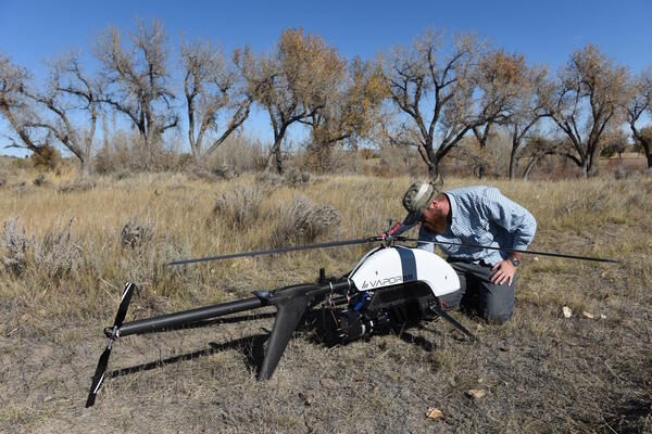
USGS researcher prepares a UAS with a mounted lidar sensor
USGS researcher prepares a UAS with a mounted lidar sensorUSGS researcher Todd Burton prepares a UAS with a mounted lidar sensor
At the request of the National Park Service in October 2017 the NUSO utilized UAS to acquire geospatial data to support development of a flood management plan for the Fort Laramie National Historic Site in Wyoming.

Pine Island Glacier’s Newest Iceberg
Pine Island Glacier in Antarctica has snapped off its share of icebergs in recent years. The frequency of noteworthy breaks is evidence that the ice shelf is becoming increasingly fragile. The latest iceberg cracked off the end of the Pine Island Glacier ice shelf around September 23, 2017.
Pine Island Glacier in Antarctica has snapped off its share of icebergs in recent years. The frequency of noteworthy breaks is evidence that the ice shelf is becoming increasingly fragile. The latest iceberg cracked off the end of the Pine Island Glacier ice shelf around September 23, 2017.

Landsat 8 image of algal bloom in Lake Erie
In September 2017, Landsat 8's Operational Land Imager (OLI) Landsat 8 captured this image of a large phytoplankton bloom in Lake Erie, near Toledo, Ohio.
In September 2017, Landsat 8's Operational Land Imager (OLI) Landsat 8 captured this image of a large phytoplankton bloom in Lake Erie, near Toledo, Ohio.

Puerto Rico after Hurricane Maria
This pair of Landsat 8 images shows the large-scale damage done to Puerto Rico. The lush green landscape in the 2016 image is replaced by a faded green. The strong winds stripped the leaves off trees to cause the degraded landscape. The forest is expected to recover.
This pair of Landsat 8 images shows the large-scale damage done to Puerto Rico. The lush green landscape in the 2016 image is replaced by a faded green. The strong winds stripped the leaves off trees to cause the degraded landscape. The forest is expected to recover.

Irma Churns Up Sediment in the Florida Keys
Hurricane Irma crossed the Florida Keys the morning of September 10, 2017, as a Category 4 hurricane with winds of 130 miles per hour. Besides damage done to structures on the islands, the storm also stirred the waters.
Hurricane Irma crossed the Florida Keys the morning of September 10, 2017, as a Category 4 hurricane with winds of 130 miles per hour. Besides damage done to structures on the islands, the storm also stirred the waters.

Hurricane Irma Slams Barbuda
The dramatic changes to the island caused by Irma, the strongest Atlantic hurricane on record, are shown in this pair of images from Landsat 8. Landsat uses shortwave-infrared, near-infrared, and green wavelengths to reveal those changes. The August 27 image shows healthy vegetation as bright green.
The dramatic changes to the island caused by Irma, the strongest Atlantic hurricane on record, are shown in this pair of images from Landsat 8. Landsat uses shortwave-infrared, near-infrared, and green wavelengths to reveal those changes. The August 27 image shows healthy vegetation as bright green.

Hurricane Harvey Flooding
Extensive flooding inundated the Gulf Coast of Texas after Hurricane Harvey made landfall as a Category 4 hurricane on August 25, 2017. Among the many waterways in southeastern Texas that exceeded flood stage was the Brazos River, which flows past Houston to its west and to the Gulf of America at Freeport.
Extensive flooding inundated the Gulf Coast of Texas after Hurricane Harvey made landfall as a Category 4 hurricane on August 25, 2017. Among the many waterways in southeastern Texas that exceeded flood stage was the Brazos River, which flows past Houston to its west and to the Gulf of America at Freeport.

Lake Erie algal bloom
Landsat 8 captured this image of Lake Erie during a harmful algal bloom event on September 26, 2017.
Landsat 8 captured this image of Lake Erie during a harmful algal bloom event on September 26, 2017.

New Rift on Greenland's Petermann Glacier
A new rift has been forming on Petermann Glacier, Greenland, throughout 2017. An older crack to the right of the new rift also seems to be extending toward the glacier's center. If this new rift meets up with the older crack, and an iceberg breaks off, it would be Petermann's third massive iceberg calving since 2010.
A new rift has been forming on Petermann Glacier, Greenland, throughout 2017. An older crack to the right of the new rift also seems to be extending toward the glacier's center. If this new rift meets up with the older crack, and an iceberg breaks off, it would be Petermann's third massive iceberg calving since 2010.

Hurricane Harvey Inundates Gulf Coast
Hurricane Harvey made landfall on the Gulf Coast of Texas as a Category 4 hurricane on the night of August 25, 2017. It then stalled over southeastern Texas as a tropical storm and continued to creep northeast over Louisiana.
Hurricane Harvey made landfall on the Gulf Coast of Texas as a Category 4 hurricane on the night of August 25, 2017. It then stalled over southeastern Texas as a tropical storm and continued to creep northeast over Louisiana.

A World of Hops
The world's largest continuous hops-growing region by area is Hallertau, just north of Munich. More than 80 percent of Germany's hops come from this 42,000-acre stretch of fertile loess soil.
The world's largest continuous hops-growing region by area is Hallertau, just north of Munich. More than 80 percent of Germany's hops come from this 42,000-acre stretch of fertile loess soil.

The Belo Monte Dam Complex, Brazil
In northern Brazil, the Belo Monte Dam complex on the Xingu River, a major tributary of the Amazon, has changed the course of the river and surrounding landscape.
In northern Brazil, the Belo Monte Dam complex on the Xingu River, a major tributary of the Amazon, has changed the course of the river and surrounding landscape.

Iceberg Separates from Larsen C Ice Shelf
Around July 10–12, 2017, in the middle of the long, dark Antarctic winter, a rift in the Larsen C Ice Shelf broke through the last few miles of ice to the Weddell Sea and formed a new iceberg. The NOAA National Ice Center has given the Delaware-sized iceberg the designation A-68.
Around July 10–12, 2017, in the middle of the long, dark Antarctic winter, a rift in the Larsen C Ice Shelf broke through the last few miles of ice to the Weddell Sea and formed a new iceberg. The NOAA National Ice Center has given the Delaware-sized iceberg the designation A-68.

Batagaika Crater and the Megaslump
An increasingly large gash has opened up in northern Russia's Siberian tundra. During the past few decades, warmer summers and shorter winters have caused permafrost in this region to thaw, which then allows the warmed soils on slopes to slump and erode.
An increasingly large gash has opened up in northern Russia's Siberian tundra. During the past few decades, warmer summers and shorter winters have caused permafrost in this region to thaw, which then allows the warmed soils on slopes to slump and erode.

Fires in the Western United States
On an average day during the fire season, multiple wildfires burn in the western United States. For example, 216 fires were active on July 7, 2017. Firefighters were battling 27 of these fires through ground and air support.
On an average day during the fire season, multiple wildfires burn in the western United States. For example, 216 fires were active on July 7, 2017. Firefighters were battling 27 of these fires through ground and air support.

7 Million Landsat Scenes and Counting!
The Landsat archive, the world's longest continuously acquired collection of space-based, moderate-resolution land remote sensing data, has now surpassed 7 million scenes since Landsat 1 first began collecting data in July 1972.
The Landsat archive, the world's longest continuously acquired collection of space-based, moderate-resolution land remote sensing data, has now surpassed 7 million scenes since Landsat 1 first began collecting data in July 1972.

Satellite Image of the Las Vegas, Lake Mead, Grand Canyon Area
Satellite Image of the Las Vegas, Lake Mead, Grand Canyon AreaThis image of the Las Vegas /Lake Mead / Grand Canyon area was acquired on June 16, 2017, with Indian Space Research Organization’s Resourcesat-2 AWiFS sensor. Images of this region can be useful to help detect changes in vegetation and water availability for growing desert communities.

Landsat 8 Scenes Top 1 Million
How many pictures have you taken with your smartphone? Too many to count? However many it is, Landsat 8 probably has you beat. Landsat 8 acquires images at a rate of about 750 per day, and just a little over 4 years after launch in February 2013, the Earth-observing satellite on May 31, 2017, acquired its 1 millionth scene!
How many pictures have you taken with your smartphone? Too many to count? However many it is, Landsat 8 probably has you beat. Landsat 8 acquires images at a rate of about 750 per day, and just a little over 4 years after launch in February 2013, the Earth-observing satellite on May 31, 2017, acquired its 1 millionth scene!

Okefenokee Fire Continues to Burn
A wildfire ignited by lightning in the Okefenokee National Wildlife Refuge on April 6, 2017, is persisting into May. Hot, dry weather and extremely dry fuels are making the fire difficult to contain. As of May 22, the blaze, also called the West Mims Fire, had burned 152,478 acres.
A wildfire ignited by lightning in the Okefenokee National Wildlife Refuge on April 6, 2017, is persisting into May. Hot, dry weather and extremely dry fuels are making the fire difficult to contain. As of May 22, the blaze, also called the West Mims Fire, had burned 152,478 acres.

Mount Pinatubo, Philippines, Erupted 26 Years Ago
Today Mount Pinatubo is relatively quiet, and about 300 meters shorter than it was before the eruption. This Landsat image pair shows the mountain several months after the eruption and more recently in 2017.
Today Mount Pinatubo is relatively quiet, and about 300 meters shorter than it was before the eruption. This Landsat image pair shows the mountain several months after the eruption and more recently in 2017.