Landsat 7 helps track Antarctica's emperor penguins
Landsat 7 helps track Antarctica's emperor penguinsSatellite image from Landsat 7 which was used to track Antarctica's emperor penguins.


Official websites use .gov
A .gov website belongs to an official government organization in the United States.

Secure .gov websites use HTTPS
A lock () or https:// means you’ve safely connected to the .gov website. Share sensitive information only on official, secure websites.

The National Land Imaging Program supports a variety of geospatial data programs and projects, including the USGS Landsat Program. Browse the images below to see some of the imagery produced using NLI-supported data sources.

Satellite image from Landsat 7 which was used to track Antarctica's emperor penguins.
Satellite image from Landsat 7 which was used to track Antarctica's emperor penguins.

Landsat 5 image of the Mt. Redoubt area on March 26, 2009 at 1:07 PM AKDT. The false color image shows the large brown ash cloud extending over the Cook Inlet and the western Kenai peninsula (right sid of image). The image also shows a whiter steam and gas plume rising from the summit of Redoubt Volcano (near upper center).
Landsat 5 image of the Mt. Redoubt area on March 26, 2009 at 1:07 PM AKDT. The false color image shows the large brown ash cloud extending over the Cook Inlet and the western Kenai peninsula (right sid of image). The image also shows a whiter steam and gas plume rising from the summit of Redoubt Volcano (near upper center).

Kingston Flood
At approximately 1:00a.m. on December 22, 2008, an earthen dam holding a containment pond at the Kingston, Tennessee Fossil Plant gave way, releasing over 500 million gallons of ash and sludge.
Kingston Flood
At approximately 1:00a.m. on December 22, 2008, an earthen dam holding a containment pond at the Kingston, Tennessee Fossil Plant gave way, releasing over 500 million gallons of ash and sludge.

On May 4, 2008, the Nargis cyclone hit the country of Burma (Myanmar) causing devastation to Rangoon (Yangon), the capital of Burma, and the surrounding area.
On May 4, 2008, the Nargis cyclone hit the country of Burma (Myanmar) causing devastation to Rangoon (Yangon), the capital of Burma, and the surrounding area.
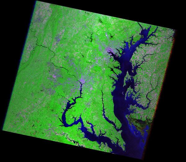
This Landsat 7 image captures the Washington, D.C., and Baltimore, MD, areas. Washington, D.C., lies in the center of the image along the Potomac River. Baltimore, in the upper-right portion of the image, is located on the western shore of Chesapeake Bay.
This Landsat 7 image captures the Washington, D.C., and Baltimore, MD, areas. Washington, D.C., lies in the center of the image along the Potomac River. Baltimore, in the upper-right portion of the image, is located on the western shore of Chesapeake Bay.

The Georgia Fire consisted of two fires, the Sweat Farm Road fire and the Big Turnaround fire. The fires were located 10 miles (16 kilometers) southwest of Waycross, Georgia, and were separated by Swamp Road.
The Georgia Fire consisted of two fires, the Sweat Farm Road fire and the Big Turnaround fire. The fires were located 10 miles (16 kilometers) southwest of Waycross, Georgia, and were separated by Swamp Road.

These images show the nearly 11,000 acres affected by the Sierra fire in Orange County, California, in February 2006.
These images show the nearly 11,000 acres affected by the Sierra fire in Orange County, California, in February 2006.

These Landsat images show the damage that New Orleans, Louisiana, received as a result of Hurricane Katrina in August 2005.
Left image: Landsat 7, acquired April 24, 2005.
Right image: Landsat 7, acquired August 30, 2005.
These Landsat images show the damage that New Orleans, Louisiana, received as a result of Hurricane Katrina in August 2005.
Left image: Landsat 7, acquired April 24, 2005.
Right image: Landsat 7, acquired August 30, 2005.

New York’s Adirondack Park is the largest publicly-protected area in the conterminous United States, greater in size than Yellowstone, Everglades, Glacier, and Grand Canyon National Parks combined.
Capital Albany
Image Source Landsat 8
Population 20,201,249
New York’s Adirondack Park is the largest publicly-protected area in the conterminous United States, greater in size than Yellowstone, Everglades, Glacier, and Grand Canyon National Parks combined.
Capital Albany
Image Source Landsat 8
Population 20,201,249

This image is an example of a Gap-Filled product. The left image is path 39 row 37, acquired over the Salton Sea in southern California on September 17, 2003; the image shows the scan gaps caused by the failed Scan Line Corrector (SLC).
This image is an example of a Gap-Filled product. The left image is path 39 row 37, acquired over the Salton Sea in southern California on September 17, 2003; the image shows the scan gaps caused by the failed Scan Line Corrector (SLC).

This satellite mosaic of the Hoosier State was created from several Landsat scenes stitched together to create one seamless image. Data from the National Elevation Dataset (NED) is also incorporated into the image. The names of major cities and county boundaries have been added.
This satellite mosaic of the Hoosier State was created from several Landsat scenes stitched together to create one seamless image. Data from the National Elevation Dataset (NED) is also incorporated into the image. The names of major cities and county boundaries have been added.

This graphic highlights the difference in thermal band resolution between Landsat 5 and Landsat 7, focusing on center pivot irrigation fields near Alliance, Nebraska. The Landsat 5 image (top), taken on July 3, 2002, has a coarser 120-meter resolution, while the Landsat 7 image (bottom), from July 2, 2002, offers greater detail with its 60-meter resolution.
This graphic highlights the difference in thermal band resolution between Landsat 5 and Landsat 7, focusing on center pivot irrigation fields near Alliance, Nebraska. The Landsat 5 image (top), taken on July 3, 2002, has a coarser 120-meter resolution, while the Landsat 7 image (bottom), from July 2, 2002, offers greater detail with its 60-meter resolution.

This image was created using Tri-Decadal Global Landsat Orthorectified ETM+ Pan-Sharpened data, and draped with National Elevation Dataset (NED) data.
Visit the Landsat Missions website to learn more about Landsat.
This image was created using Tri-Decadal Global Landsat Orthorectified ETM+ Pan-Sharpened data, and draped with National Elevation Dataset (NED) data.
Visit the Landsat Missions website to learn more about Landsat.

In stunning detail, the Landsat Image Mosaic of Antarctica (LIMA) brings Antarctica to life, both for the scientific community and the general public.
In stunning detail, the Landsat Image Mosaic of Antarctica (LIMA) brings Antarctica to life, both for the scientific community and the general public.

This true-color image was taken by the Enhanced Thematic Mapper Plus (ETM+) sensor aboard the Landsat 7 satellite on September 12, 2001, at roughly 11:30 a.m. Eastern Daylight Savings Time. A day after the attack, smoke continues to billow out of the collapsed Twin Towers.
This true-color image was taken by the Enhanced Thematic Mapper Plus (ETM+) sensor aboard the Landsat 7 satellite on September 12, 2001, at roughly 11:30 a.m. Eastern Daylight Savings Time. A day after the attack, smoke continues to billow out of the collapsed Twin Towers.

Landsat 7 imagery was used to create a full continent mosaic of Antarctica.
Landsat 7 imagery was used to create a full continent mosaic of Antarctica.
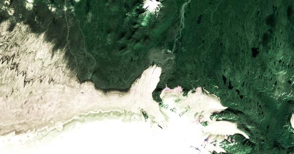
This Landsat image displays the Eyjabakkajökull Glacier, an outlet glacier of the Vatnajökull ice cap in Iceland. (N64.6756, W15.5843)
Landsat 7 Path 216 Row 15
Acquired September 16, 2000
This Landsat image displays the Eyjabakkajökull Glacier, an outlet glacier of the Vatnajökull ice cap in Iceland. (N64.6756, W15.5843)
Landsat 7 Path 216 Row 15
Acquired September 16, 2000

These images show the progression of deforestation in Bolivia from 1975 to 2000. This area lies east of Santa Cruz de la Sierra, Bolivia, in an area of tropical dry forest.
These images show the progression of deforestation in Bolivia from 1975 to 2000. This area lies east of Santa Cruz de la Sierra, Bolivia, in an area of tropical dry forest.

NASA launched the Terra satellite in the Earth Observing System series containing MODIS and ASTER instruments in 1999. Data from the instruments is stored at and distributed from the LP DAAC, and EROS scientists use the data in a variety of projects.
NASA launched the Terra satellite in the Earth Observing System series containing MODIS and ASTER instruments in 1999. Data from the instruments is stored at and distributed from the LP DAAC, and EROS scientists use the data in a variety of projects.

Landsat 7 captured this image of Upolu Island in Samoa in July of 1999. The coral reefs around Upolu and surrounding islands have been studied for longevity. Coral reefs around the island are virtually continuous, forming an extensive shallow reef flat. Landsat 7 July 6, 1999.
Landsat 7 captured this image of Upolu Island in Samoa in July of 1999. The coral reefs around Upolu and surrounding islands have been studied for longevity. Coral reefs around the island are virtually continuous, forming an extensive shallow reef flat. Landsat 7 July 6, 1999.
