
Eleven days after a wildfire first sparked south of Fort McMurray in northern Alberta, Landsat 8’s Operational Land Imager (OLI) captured imagery of one of the most destructive infernos in Canadian history. The fire has burned an area approaching 600,000 acres.
Images
The National Land Imaging Program supports a variety of geospatial data programs and projects, including the USGS Landsat Program. Browse the images below to see some of the imagery produced using NLI-supported data sources.
Filter Total Items: 508

Fort McMurray Wildfire (Before and After)
Eleven days after a wildfire first sparked south of Fort McMurray in northern Alberta, Landsat 8’s Operational Land Imager (OLI) captured imagery of one of the most destructive infernos in Canadian history. The fire has burned an area approaching 600,000 acres.

Fort McMurray Wildfire
Image of the Week: A massive wildfire burning near Fort McMurray in Alberta, Canada, fueled by dry conditions and high winds, has destroyed 1,600 structures and forced more than 88,000 people to evacuate the area so far.
Image of the Week: A massive wildfire burning near Fort McMurray in Alberta, Canada, fueled by dry conditions and high winds, has destroyed 1,600 structures and forced more than 88,000 people to evacuate the area so far.

Landsat Played Role in Confirming 1986 Chernobyl Disaster
Landsat Played Role in Confirming 1986 Chernobyl DisasterWhen the Chernobyl Nuclear Power Plant exploded 30 years ago, on April 26, 1986, Landsat 5 was the first civilian satellite to confirm the disaster near Pripyat, Ukraine, in the agricultural heartland of the Soviet Union.

Alaska Surveyors Circa 1924
Alaska surveying crew circa 1924 using alidade and plane table; transportation by dogsled. USGS photo files.
Alaska surveying crew circa 1924 using alidade and plane table; transportation by dogsled. USGS photo files.

Landsat's View of the Boston Marathon
The 122nd Boston Marathon, the oldest annual marathon in the world, takes place on April 16, 2018. This Landsat 8 image shows the April landscape of eastern Massachusetts, before vegetation has greened up. The yellow line indicates the point-to-point route that the marathon follows.
The 122nd Boston Marathon, the oldest annual marathon in the world, takes place on April 16, 2018. This Landsat 8 image shows the April landscape of eastern Massachusetts, before vegetation has greened up. The yellow line indicates the point-to-point route that the marathon follows.

Beaufort Sea Ice Experiences Unusually Early Breakup
Beaufort Sea Ice Experiences Unusually Early BreakupIce covering Beaufort Sea near the Arctic Ocean typically reaches full-blown breakup by late May each year as air and water temperatures warm, and as daylight turns longer. But 2016 has been dramatically different.

Wildfires Scorch Large Swaths Along Oklahoma-Kansas Border
Wildfires Scorch Large Swaths Along Oklahoma-Kansas BorderUsing shortwave infrared, near infrared, and visible bands, these Landsat images provide a before and after look at the 350 Complex and Anderson Creek fires.
Wildfires Scorch Large Swaths Along Oklahoma-Kansas Border
Wildfires Scorch Large Swaths Along Oklahoma-Kansas BorderUsing shortwave infrared, near infrared, and visible bands, these Landsat images provide a before and after look at the 350 Complex and Anderson Creek fires.

Landsat Chronicles Deforestation in Colombia
Landsat images used by Colombia's Institute of Hydrology, Meteorology and Environmental Studies (IDEAM) determined that total forest land cover in the country has dropped from 56.8 percent in 1990 to 52.6 percent by 2012, or almost 5 million hectares.
Landsat images used by Colombia's Institute of Hydrology, Meteorology and Environmental Studies (IDEAM) determined that total forest land cover in the country has dropped from 56.8 percent in 1990 to 52.6 percent by 2012, or almost 5 million hectares.

Hispaniola
Image of the Week: Landsat imagery shows a dramatic change in lakes Azuéi and Enriquillo, inland saltwater lakes on the Caribbean island of Hispaniola that are known for their crocodiles and iguanas.
Image of the Week: Landsat imagery shows a dramatic change in lakes Azuéi and Enriquillo, inland saltwater lakes on the Caribbean island of Hispaniola that are known for their crocodiles and iguanas.

New Delhi Among Fastest Growing Urban Areas in the World
New Delhi Among Fastest Growing Urban Areas in the WorldIn a world becoming increasingly urbanized, few cities have seen growth as dramatic as that occurring in India's capital of New Delhi.
New Delhi Among Fastest Growing Urban Areas in the World
New Delhi Among Fastest Growing Urban Areas in the WorldIn a world becoming increasingly urbanized, few cities have seen growth as dramatic as that occurring in India's capital of New Delhi.

Saudi Wheat Experiment Relied on Fossil Water
These Landsat images show the remarkable transformation of desert sand in 1986 into green, circular fields—some as large as 1 kilometer across—by 2016
These Landsat images show the remarkable transformation of desert sand in 1986 into green, circular fields—some as large as 1 kilometer across—by 2016

Kilauea, Mauna Loa Volcanoes Shape the Face of Hawaii
Kilauea, Mauna Loa Volcanoes Shape the Face of HawaiiThough the park celebrates its 100th anniversary on August 1, 2016, its main attractions-Kilauea and Mauna Loa volcanoes-have been adding to the land mass of Hawaii’s “Big Island” for at least 400,000 years.

Rhode Island Landsat State Mosaic
The total area (land and water) of Rhode Island is only 1,545 square miles. The state measures about 37 miles east-west, and about 48 miles north-south.
Capital Providence
Image Source Landsat 8
Population 1,097,379
Number of Pixels 3,162,631
The total area (land and water) of Rhode Island is only 1,545 square miles. The state measures about 37 miles east-west, and about 48 miles north-south.
Capital Providence
Image Source Landsat 8
Population 1,097,379
Number of Pixels 3,162,631

Lithium Mining in Salar de Atacama, Chile
The Salar de Atacama in Chile is a large, dry salt flat surrounded by mountain ranges and is one of the driest places on Earth. Parts of the Atacama Desert have gone without rain for as long as people have been keeping track, but water rich in dissolved salts lies beneath this flat surface. The Salar is particularly rich in lithium salts.
The Salar de Atacama in Chile is a large, dry salt flat surrounded by mountain ranges and is one of the driest places on Earth. Parts of the Atacama Desert have gone without rain for as long as people have been keeping track, but water rich in dissolved salts lies beneath this flat surface. The Salar is particularly rich in lithium salts.

Beauty of Earth Science Revealed Within Great Smoky Mountains
Beauty of Earth Science Revealed Within Great Smoky MountainsEarth Science reminds us that the study of Earth and its biological processes can occur anywhere—whether we realize it or not.
Beauty of Earth Science Revealed Within Great Smoky Mountains
Beauty of Earth Science Revealed Within Great Smoky MountainsEarth Science reminds us that the study of Earth and its biological processes can occur anywhere—whether we realize it or not.

Hurricane Sandy Slammed Eastern U.S. Four Years Ago
Hurricane Sandy Slammed Eastern U.S. Four Years AgoHigh Resolution Orthoimagery archived at the USGS EROS Center and inset into the larger image show the New Jersey coastal town of Mantoloking five years before Sandy made landfall, as well as the slow recovery three years after the storm.

Landsat Image of Mount St. Helens on May 22, 1983
Land Remote Sensing Image of Mount St. Helens on May 22, 1983. The volcanic blast on May 18, 1980, devastated more than 150 square miles of forest within a few minutes. In this Landsat false-color images, forest appears as bright red interspersed with patches of logging. Snow appears white, and ash is gray.
Land Remote Sensing Image of Mount St. Helens on May 22, 1983. The volcanic blast on May 18, 1980, devastated more than 150 square miles of forest within a few minutes. In this Landsat false-color images, forest appears as bright red interspersed with patches of logging. Snow appears white, and ash is gray.

Canyonlands National Park as seen by Landsat 8
Canyonlands National Park was one of four national parks established (1964) under the leadership of Interior Secretary Stewart Udall.
Landsat 8, acquired March 29, 2015.
Canyonlands National Park was one of four national parks established (1964) under the leadership of Interior Secretary Stewart Udall.
Landsat 8, acquired March 29, 2015.

Eltanin Bay, West Antarctica_Landsat 8 OLI
Landsat 8 OLI image of retreating glacial ice near Eltanin Bay, West Antarctica
Landsat 8 OLI image of retreating glacial ice near Eltanin Bay, West Antarctica

Remote pilot monitoring the flight of a UAS at the Sequoyah NWR
Remote pilot monitoring the flight of a UAS at the Sequoyah NWRRemote pilot monitoring the flight of a UAS at the Sequoyah NWR
The NUSO and the USFWS in February 2015 evaluated the use of UAS data collection to improve waterfowl survey accuracy and eliminate pilot/passenger safety risks associated with manned aircraft data collection.
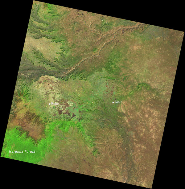
Landsat View of Ethiopia’s Highlands and the Harenna Forest
Landsat View of Ethiopia’s Highlands and the Harenna ForestThis Landsat 8 image of central Ethiopia, acquired January 1, 2014, uses the shortwave infrared, near infrared, and red spectral bands (bands 6,5,4) to emphasize vegetation and land cover. In this combination, healthy vegetation appears bright green.