
The USGS R/V Peterson conducts monthly cruises covering the San Francisco Estuary up to the Sacramento River at Rio Vista, California. The USGS has been researching and monitoring the San Francisco Estuary since 1969.
Images
Images intro.
Filter Total Items: 139

USGS R/V Peterson
The USGS R/V Peterson conducts monthly cruises covering the San Francisco Estuary up to the Sacramento River at Rio Vista, California. The USGS has been researching and monitoring the San Francisco Estuary since 1969.
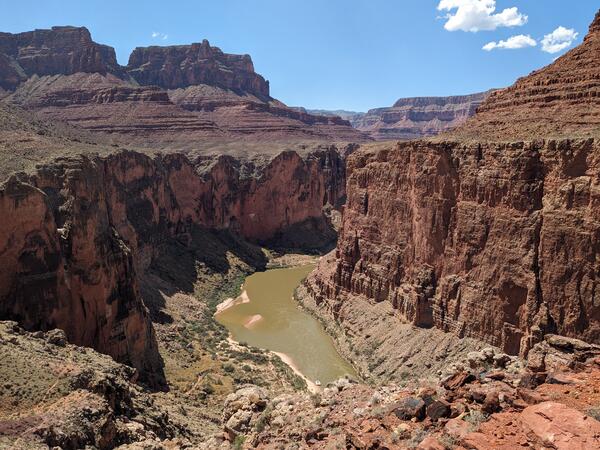
Grand_Canyon_20230908_Brennan.jpg
Photograph of the Colorado River in the Grand Canyon, Arizona, USA. Photo taken on September 8, 2023.
By
Core Science Systems Mission Area, Natural Hazards Mission Area, Water Resources Mission Area, Mineral Resources Program, National Cooperative Geologic Mapping Program, National Water Quality Program, Toxic Substances Hydrology, Geology, Geophysics, and Geochemistry Science Center, Geology, Minerals, Energy, and Geophysics Science Center, Geosciences and Environmental Change Science Center, New Mexico Water Science Center, Southwest Biological Science Center, Denver Radiogenic Isotope Lab, National Water Quality Laboratory, New Mexico Water Science Center Sediment Laboratory, Organic Geochemistry Laboratory, Geological Materials Repository, Geology and Ecology of National Parks, Colorado River Basin: Actionable and Strategic Integrated Science and Technology

Pipettes_5_23_23_JED.jpg
Image of pipettors used in the laboratory. Pipettes are stored on charging docking stations.
Image of pipettors used in the laboratory. Pipettes are stored on charging docking stations.

Plot of decadal change in Radium concentration vs. road salt application rate
Plot of decadal change in Radium concentration vs. road salt application rateGraph of decadal change in Radium concentration compared to road salt application rate (Lindsay and others, 2021). Increases in concentrations of radium are correlated with road-salt application, and multiple lines of evidence support that the relation is causal.

Strontium measured in wells tapping U.S. principal aquifers
Strontium measured in wells tapping U.S. principal aquifersConcentrations of strontium in samples of groundwater from drinking-water wells and shallow monitoring wells.
Strontium measured in wells tapping U.S. principal aquifers
Strontium measured in wells tapping U.S. principal aquifersConcentrations of strontium in samples of groundwater from drinking-water wells and shallow monitoring wells.

Pole Bridge Creek (2) sampled as part of RSQA
Pole Bridge Creek is one of the sites investigated in the USGS Regional Stream Quality Assessment, during which water quality and ecological condition were sampled.
Pole Bridge Creek is one of the sites investigated in the USGS Regional Stream Quality Assessment, during which water quality and ecological condition were sampled.

Sugar Creek, near New Palestine, Indiana
Sugar Creek, near New Palestine, Indiana. Sugar Creek is part of a long-term USGS stream monitoring project, and was one of 72 U.S.
Sugar Creek, near New Palestine, Indiana. Sugar Creek is part of a long-term USGS stream monitoring project, and was one of 72 U.S.

Pesticides in Streams Photo copy.jpg
Photo of stream in urban environment with green lawn beside it. Photo credit: Alan Cressler USGS
Photo of stream in urban environment with green lawn beside it. Photo credit: Alan Cressler USGS

Winter water-quality sample collection in the Connecticut River, CT
Winter water-quality sample collection in the Connecticut River, CTBrittney Izbicki, USGS, at the edge of the ice in the Connecticut River, preparing to collect water-quality samples.
Winter water-quality sample collection in the Connecticut River, CT
Winter water-quality sample collection in the Connecticut River, CTBrittney Izbicki, USGS, at the edge of the ice in the Connecticut River, preparing to collect water-quality samples.

Clearing ice from the path to the river for water-quality sampling
Clearing ice from the path to the river for water-quality samplingDavid Sullivan, USGS, using an ice bar to chip away at the ice built up on the trail to get down to the water-quality sampling site at USGS gage Connecticut River near Thompsonville, CT

Collecting winter water-quality samples from the Connecticut River nea
Collecting winter water-quality samples from the Connecticut River neaTheresa Armijo, USGS, collecting water-quality samples from the Connecticut River by USGS gage 01184000, Connecticut River near Thompsonville
Collecting winter water-quality samples from the Connecticut River nea
Collecting winter water-quality samples from the Connecticut River neaTheresa Armijo, USGS, collecting water-quality samples from the Connecticut River by USGS gage 01184000, Connecticut River near Thompsonville

Collecting winter water-quality samples in the Connecticut River, CT
Collecting winter water-quality samples in the Connecticut River, CTColin Sweeney, USGS, collecting water-quality samples from the Connecticut River, CT
Collecting winter water-quality samples in the Connecticut River, CT
Collecting winter water-quality samples in the Connecticut River, CTColin Sweeney, USGS, collecting water-quality samples from the Connecticut River, CT

Overview of Water Quality in Principal Aquifers
Overview of Water Quality in Principal Aquifers

Prescription medication
Hormones and pharmaceuticals, widely used for treatment of humans, domestic animals, and livestock, have the potential to enter the environment, including groundwater. In 2009, nearly 70% of Americans took at least one prescription drug, and more than half took 2 or more.
Hormones and pharmaceuticals, widely used for treatment of humans, domestic animals, and livestock, have the potential to enter the environment, including groundwater. In 2009, nearly 70% of Americans took at least one prescription drug, and more than half took 2 or more.

Dead Run is a typical urban creek in the Baltimore area (photo 1)
Dead Run is a typical urban creek in the Baltimore area (photo 1)Dead Run is an urban creek in Catonsville, Maryland, near Baltimore. Research has found that about half of the bed sediment originates as particulate matter on pavement that then is washed into the creek via storm drains.

Dead Run is a typical urban creek in the Baltimore area (photo 2)
Dead Run is a typical urban creek in the Baltimore area (photo 2)Dead Run is an urban creek in Catonsville, Maryland, near Baltimore. Research has found that about half of the bed sediment originates as particulate matter on pavement that then is washed into the creek via storm drains.

Dead Run is a typical urban creek in the Baltimore area (Photo 5)
Dead Run is a typical urban creek in the Baltimore area (Photo 5)Dead Run is an urban creek in Catonsville, Maryland, near Baltimore. Research has found that about half of the bed sediment originates as particulate matter on pavement that then is washed into the creek via storm drains.

Dead Run is a typical urban creek in the Baltimore area (Photo 3)
Dead Run is a typical urban creek in the Baltimore area (Photo 3)Dead Run is an urban creek in Catonsville, Maryland, near Baltimore. Research has found that about half of the bed sediment originates as particulate matter on pavement that then is washed into the creek via storm drains.

Dead Run is a typical urban creek in the Baltimore area (Photo 4)
Dead Run is a typical urban creek in the Baltimore area (Photo 4)Dead Run is an urban creek in Catonsville, Maryland, near Baltimore. Research has found that about half of the bed sediment originates as particulate matter on pavement that then is washed into the creek via storm drains.

Harmful algal blooms turn water in Milford Lake emerald green
Harmful algal blooms turn water in Milford Lake emerald greenHarmful algal blooms turn water in Milford Lake emerald green
Harmful algal blooms turn water in Milford Lake emerald green
Harmful algal blooms turn water in Milford Lake emerald greenHarmful algal blooms turn water in Milford Lake emerald green

Mesocosm with rocks that are colonized with natural stream communities
Mesocosm with rocks that are colonized with natural stream communitiesPhoto of a mesocosm like utilized in the study. The rocks are colonized with natural stream communities of aquatic insects. Fresh stream water is circulated through the mesocosm and individual mesocosms are dosed with different concentrations of a neonicotinoid compound.