
Colorized satellite imagery from 2017-09-19 15:00 UTC of Hurricane Maria impacting the Eastern Caribbean. Data provided by NOAA. Base image is intellectual property of NOAA and is used herein under license. Copyright Esri and its creator.
Images
Images related to Hurricane Maria.

Hurricane Maria Impacting the Eastern Caribbean
Colorized satellite imagery from 2017-09-19 15:00 UTC of Hurricane Maria impacting the Eastern Caribbean. Data provided by NOAA. Base image is intellectual property of NOAA and is used herein under license. Copyright Esri and its creator.

Hurricane Tracks, Puerto Rico
Hurricane tracks for Hugo (1989), Georges (1998), Irma (2017) and Maria (2017). Data provided by NOAA. Base image is intellectual property of Esri and is used herein under license. Copyright Esri and its creator.
Hurricane tracks for Hugo (1989), Georges (1998), Irma (2017) and Maria (2017). Data provided by NOAA. Base image is intellectual property of Esri and is used herein under license. Copyright Esri and its creator.

Huracanes aumentan el riesgo de inundaciones futuras en Puerto Rico, 1
Huracanes aumentan el riesgo de inundaciones futuras en Puerto Rico, 1RESUMEN DEL REPORTE
Los daños causados por los huracanes a los arrecifes de coral en 2017 aumentan el riesgo de inundaciones futuras en Puerto Rico y Florida
Huracanes aumentan el riesgo de inundaciones futuras en Puerto Rico, 1
Huracanes aumentan el riesgo de inundaciones futuras en Puerto Rico, 1RESUMEN DEL REPORTE
Los daños causados por los huracanes a los arrecifes de coral en 2017 aumentan el riesgo de inundaciones futuras en Puerto Rico y Florida

Social and economic benefits of coral reef restoration: Puerto Rico 2
Social and economic benefits of coral reef restoration: Puerto Rico 2Coral reef restoration can yield significant flood reduction benefits. These natural defenses were damaged in the 2017 hurricanes; their recovery would reduce the risks of further storm damages to nature, people and property.

Beneficios sociales y económicos de la restauración: Puerto Rico 1
Beneficios sociales y económicos de la restauración: Puerto Rico 1RESUMEN DEL REPORTE
Los beneficios sociales y económicos de la restauración de arrecifes de coral en Puerto Rico
PUNTOS CLAVE
Beneficios sociales y económicos de la restauración: Puerto Rico 1
Beneficios sociales y económicos de la restauración: Puerto Rico 1RESUMEN DEL REPORTE
Los beneficios sociales y económicos de la restauración de arrecifes de coral en Puerto Rico
PUNTOS CLAVE

Beneficios sociales y económicos de la restauración: Puerto Rico 2
Beneficios sociales y económicos de la restauración: Puerto Rico 2La restauración de los arrecifes de coral puede producir beneficios significativos en la reducción de inundaciones. Estas defensas naturales sufrieron daños a causa de los huracanes de 2017; su recuperación reduciría riesgos adicionales a la naturaleza, las personas y propiedades causados por tormentas.

Social and economic benefits of coral reef restoration: Puerto Rico 1
Social and economic benefits of coral reef restoration: Puerto Rico 1Report Summary
The Social and Economic Benefits of Coral Reef Restoration in Puerto Rico
Key Points
Social and economic benefits of coral reef restoration: Puerto Rico 1
Social and economic benefits of coral reef restoration: Puerto Rico 1Report Summary
The Social and Economic Benefits of Coral Reef Restoration in Puerto Rico
Key Points

Hurricanes increase future flood risk in Puerto Rico and Florida, 1
Hurricanes increase future flood risk in Puerto Rico and Florida, 1Report Summary
Hurricane Damage to Coral Reefs in 2017 Increases Future Flood Risk in Puerto Rico and Florida
The damage to reef natural infrastructure from Hurricanes Irma and Maria puts U.S. people and property at significant risk of future flooding
Key Points

Huracanes aumentan el riesgo de inundaciones futuras en Puerto Rico, 2
Huracanes aumentan el riesgo de inundaciones futuras en Puerto Rico, 2Las consecuencias significativas del riesgo de inundación debido a los daños en los arrecifes de coral causado por los huracanes Irma y María clarifican por qué los beneficios de defensa de esta infraestructura natural deben recuperarse, repararse y restaurarse.

Hurricanes increase future flood risk in Puerto Rico and Florida, 2
Hurricanes increase future flood risk in Puerto Rico and Florida, 2The significant flood risk consequences of damage to coral reefs from Hurricanes Irma and Maria clarify why the defense benefits from this natural infrastructure should be recovered, repaired and restored.

Annual coastal hazard risk increase due to hurricanes in Florida
Annual coastal hazard risk increase due to hurricanes in FloridaMaps for the southern part of the Florida coastline show the increase in annual coastal hazard risk due to damage by Hurricanes Irma and Maria.
- Increase in population at risk due to coral reef damage per kilometer (left)
- Increase in value ($) of assets at risk due to coral reef damage per kilometer (right)

Impact of damage by hurricanes Irma and Maria in Puerto Rico
Impact of damage by hurricanes Irma and Maria in Puerto RicoMaps of Puerto Rico show the increase in annual coastal hazard risk due to damage by Hurricanes Irma and Maria.
- Increase in population at risk due to coral reef damage per kilometer (top)
- Increase in value ($) of assets at risk due to coral reef damage per kilometer (bottom)

On a hillside in Las Marias, USGS scientists examine landslide effects
On a hillside in Las Marias, USGS scientists examine landslide effectsUSGS ground failure experts examine landslides after Hurricane Maria in the municipality of Las Marias, Puerto Rico.
On a hillside in Las Marias, USGS scientists examine landslide effects
On a hillside in Las Marias, USGS scientists examine landslide effectsUSGS ground failure experts examine landslides after Hurricane Maria in the municipality of Las Marias, Puerto Rico.

A helicopter flight reveals landslides' damage in Utuado municipality
A helicopter flight reveals landslides' damage in Utuado municipalityAn aerial view of landslide damage after Hurricane Maria in Utuado municipality, Puerto Rico.
A helicopter flight reveals landslides' damage in Utuado municipality
A helicopter flight reveals landslides' damage in Utuado municipalityAn aerial view of landslide damage after Hurricane Maria in Utuado municipality, Puerto Rico.
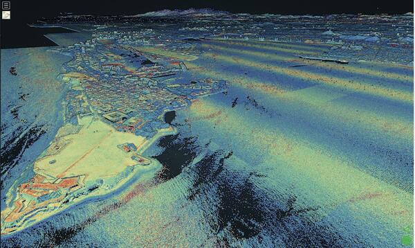
Lidar point cloud, Pre-Hurricane PR, rotate and zoom
Lidar point cloud, Pre-Hurricane PR, rotate and zoomFigure 3: Zooming in and rotating scene in 3D from figure 2. Points coloer by laser intensity (blue = low intensity, red = high intensity).
Lidar point cloud, Pre-Hurricane PR, rotate and zoom
Lidar point cloud, Pre-Hurricane PR, rotate and zoomFigure 3: Zooming in and rotating scene in 3D from figure 2. Points coloer by laser intensity (blue = low intensity, red = high intensity).

3DEP, Lidar point cloud, Pre-Hurricane Maria
Figure 2: Zooming in to red rectangle A from figure 1. Points colored by laser intensity (blue = low intensity, red = high intensity).
Figure 2: Zooming in to red rectangle A from figure 1. Points colored by laser intensity (blue = low intensity, red = high intensity).

A Rapid Deployment Gauge in Puerto Rico
This USGS Rapid Deployment Gauge was installed near Morovis, Puerto Rico, to monitor the Río Grande de Manatí after Hurricane Maria destroyed the permanent streamgage which typically monitors the river. USGS photo.
This USGS Rapid Deployment Gauge was installed near Morovis, Puerto Rico, to monitor the Río Grande de Manatí after Hurricane Maria destroyed the permanent streamgage which typically monitors the river. USGS photo.

Documenting landslides in Puerto Rico caused by Hurricane Maria.
Documenting landslides in Puerto Rico caused by Hurricane Maria.Bill Schulz, USGS Research Geologist, takes photographs of Puerto Rican hillsides from a U.S. Army helicopter to document landslides caused by Hurricane Maria.
Documenting landslides in Puerto Rico caused by Hurricane Maria.
Documenting landslides in Puerto Rico caused by Hurricane Maria.Bill Schulz, USGS Research Geologist, takes photographs of Puerto Rican hillsides from a U.S. Army helicopter to document landslides caused by Hurricane Maria.

Puerto Rico after Hurricane Maria
This pair of Landsat 8 images shows the large-scale damage done to Puerto Rico. The lush green landscape in the 2016 image is replaced by a faded green. The strong winds stripped the leaves off trees to cause the degraded landscape. The forest is expected to recover.
This pair of Landsat 8 images shows the large-scale damage done to Puerto Rico. The lush green landscape in the 2016 image is replaced by a faded green. The strong winds stripped the leaves off trees to cause the degraded landscape. The forest is expected to recover.