Schematic diagram of model domain and variables comprised of the lower shoreface (dark blue), upper shoreface (light blue), and beach/back barrier (yellow) environments.


Official websites use .gov
A .gov website belongs to an official government organization in the United States.

Secure .gov websites use HTTPS
A lock () or https:// means you’ve safely connected to the .gov website. Share sensitive information only on official, secure websites.

I study the geology of coastal margins, specifically how sediment availability and fluxes influence coastal evolution over a variety of time and space scales. My work, which spans the Atlantic and Gulf coasts, supports coastal management by providing insight into modern and future coastal behavior, the extent and quality of sediment resources, and spatial variability in ecosystem resilience.
I received a B.S. in Marine Science and a B.A. in Spanish from the University of South Carolina and a Ph.D. in Marine Science with a specialization in Coastal Geology from the Virginia Institute of Marine Science. In 2008, I started an NRC Postdoctoral Research Associateship at the Naval Research Laboratory at Stennis Space Center in Mississippi. In 2010, I began working for the USGS at the Saint Petersburg Coastal and Marine Science Center, where I explore how geologic variability influences coastal system change over a range of time scales. Using geophysics, remote sensing, and sediment sampling, I characterize coastal geology and identify relationships between geology and coastal system response to climate and storms. Also, I integrate observations with models to quantify the impact of existing variability on future coastal response.


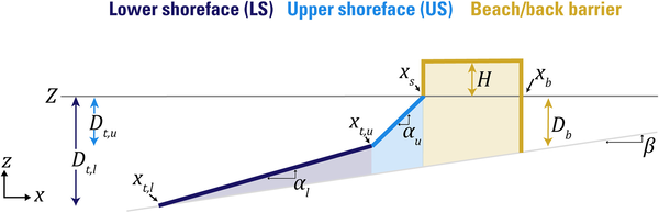
Schematic diagram of model domain and variables comprised of the lower shoreface (dark blue), upper shoreface (light blue), and beach/back barrier (yellow) environments.
Schematic diagram of model domain and variables comprised of the lower shoreface (dark blue), upper shoreface (light blue), and beach/back barrier (yellow) environments.

A floating sled that enables sub‐bottom surveying in shallow water, nearshore, and shore‐face environments. The sled is equipped with an EdgeTech SB‐512i chirp system and single‐beam sonar. This equipment is used to collect seismic sub‐bottom profiles and single‐beam bathymetry.
A floating sled that enables sub‐bottom surveying in shallow water, nearshore, and shore‐face environments. The sled is equipped with an EdgeTech SB‐512i chirp system and single‐beam sonar. This equipment is used to collect seismic sub‐bottom profiles and single‐beam bathymetry.
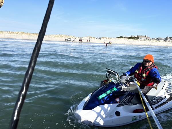
BJ Reynolds of the St. Petersburg Coastal and Marine Science Center operates a personal watercraft near the shoreline of Seven Mile Island, New Jersey. This vessel is used to collect single beam bathymetry (depth and seafloor shape) in the nearshore, and the equipment on the shoreline is used to collect chirp seismic reflection on the shoreface and inner shelf.
BJ Reynolds of the St. Petersburg Coastal and Marine Science Center operates a personal watercraft near the shoreline of Seven Mile Island, New Jersey. This vessel is used to collect single beam bathymetry (depth and seafloor shape) in the nearshore, and the equipment on the shoreline is used to collect chirp seismic reflection on the shoreface and inner shelf.

A scientist deploys a sound velocity cast from a boat while conducting a chirp geophysical survey offshore of the Rockaway Peninsula, New York. These geophysical data were used to quantify volumes of available shoreface sediment on this margin.
A scientist deploys a sound velocity cast from a boat while conducting a chirp geophysical survey offshore of the Rockaway Peninsula, New York. These geophysical data were used to quantify volumes of available shoreface sediment on this margin.
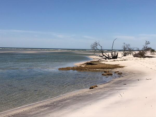
Wilderness Inlet in 2018, which was formed by Hurricane Sandy in 2012, showing dying trees and a degraded marsh.
Wilderness Inlet in 2018, which was formed by Hurricane Sandy in 2012, showing dying trees and a degraded marsh.
Schematic diagram of model domain and variables comprised of the lower shoreface (dark blue), upper shoreface (light blue), and beach/back barrier (yellow) environments.
Schematic diagram of model domain and variables comprised of the lower shoreface (dark blue), upper shoreface (light blue), and beach/back barrier (yellow) environments.
A floating sled that enables sub‐bottom surveying in shallow water, nearshore, and shore‐face environments. The sled is equipped with an EdgeTech SB‐512i chirp system and single‐beam sonar. This equipment is used to collect seismic sub‐bottom profiles and single‐beam bathymetry.
A floating sled that enables sub‐bottom surveying in shallow water, nearshore, and shore‐face environments. The sled is equipped with an EdgeTech SB‐512i chirp system and single‐beam sonar. This equipment is used to collect seismic sub‐bottom profiles and single‐beam bathymetry.
BJ Reynolds of the St. Petersburg Coastal and Marine Science Center operates a personal watercraft near the shoreline of Seven Mile Island, New Jersey. This vessel is used to collect single beam bathymetry (depth and seafloor shape) in the nearshore, and the equipment on the shoreline is used to collect chirp seismic reflection on the shoreface and inner shelf.
BJ Reynolds of the St. Petersburg Coastal and Marine Science Center operates a personal watercraft near the shoreline of Seven Mile Island, New Jersey. This vessel is used to collect single beam bathymetry (depth and seafloor shape) in the nearshore, and the equipment on the shoreline is used to collect chirp seismic reflection on the shoreface and inner shelf.
A scientist deploys a sound velocity cast from a boat while conducting a chirp geophysical survey offshore of the Rockaway Peninsula, New York. These geophysical data were used to quantify volumes of available shoreface sediment on this margin.
A scientist deploys a sound velocity cast from a boat while conducting a chirp geophysical survey offshore of the Rockaway Peninsula, New York. These geophysical data were used to quantify volumes of available shoreface sediment on this margin.
Wilderness Inlet in 2018, which was formed by Hurricane Sandy in 2012, showing dying trees and a degraded marsh.
Wilderness Inlet in 2018, which was formed by Hurricane Sandy in 2012, showing dying trees and a degraded marsh.