
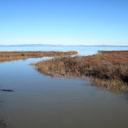
To adapt to rising sea levels, coastal wetlands can migrate landward at the expense of adjacent freshwater wetlands and upland ecosystems, but migration can be hindered by natural and anthropogenic barriers. This photo shows marsh migration constrained by topographic and urban barriers in southern California.
Karen Thorne, Ph.D.
Dr. Karen Thorne is a Research Ecologist with the USGS Western Ecological Research Center,
Her research expertise is on coastal ecosystems and understanding ecosystem services, wetland ecology and restoration, impacts from inundation and storms, and nature-based solutions. She received her Ph.D. and MS from the University of California, Davis.
Dr. Thorne's interests lie in conservation and management issues surrounding coastal ecosystems within a changing environment and management landscape. The research she conducts is critical to understanding the role that coastal ecosystems provide, both environmentally and economically. The research she conducts specifically helps guide Federal, State, and local landowners and managers in planning for more resilient and adaptable habitats; assists in informing the impacts or benefits needed to maintain ecosystem values; and provides methods and tools that identify and help landowners and regulators improve the restoration needed to off-set anthropogenic impacts in coastal environments. Current research focuses include assessing flooding impacts to mangrove and marsh ecosystem processes. Also, understanding ecological processes for marsh, mangrove, and seagrass restoration to inform management in the U.S. and South Pacific islands. Her research is based on field data collection methods that can be used to inform decision-making for managing emerging concerns.
Science and Products
Filter Total Items: 27

Coastal Wetland Vulnerability to Climate Change and Sea-Level Rise: Understanding Ecological Thresholds and Ecosystem Transformations
Eighteen USGS coastal scientists from all four coasts of the conterminous United States are working together to advance the understanding of climate change and sea-level rise impacts to coastal wetlands.
By
California Water Science Center, Chesapeake Bay Activities, Eastern Ecological Science Center, Florence Bascom Geoscience Center, Great Lakes Science Center, Pacific Coastal and Marine Science Center, St. Petersburg Coastal and Marine Science Center, Western Ecological Research Center (WERC), Western Geographic Science Center, Wetland and Aquatic Research Center , Woods Hole Coastal and Marine Science Center

Habitat Vulnerability to Climate Change: Identifying Climate Change Induced Mass Mortality Events Across Large Landscapes of the United States
USGS researchers will characterize extreme climatic events across U.S. following a review of case studies of mass mortality events associated with climate extremes including drought, precipitation, freeze, heat waves, and storm events.

Spread of invasive vegetation under climate change in the national parks of the Klamath Region
Project Overview: The Klamath Region of Oregon and California is a global hotspot of biodiversity, but invasive species, climate change, and severe fires threaten native biodiversity, even within national parks. Scientists supported by this Southwest CASC project will create early-warning maps of where invasive plants are most likely to spread, helping national park managers target their
Enhancing Community and Wildlife Resilience to Sea‐Level Rise and Infrastructure Development in the San Pablo Baylands
Project Overview: The San Pablo Baylands support critical wildlife habitat and major transportation infrastructure, but the combined effects of sea-level rise and planned highway redesigns on habitat and public access remain uncertain. Scientists supported by this Southwest CASC project will work with federal, state, and regional managers to fill key data gaps and model how sea-level...
Modeling vulnerability for San Francisco Bay estuary tidal marshes
Karen Thorne researches the effects of inundation and ecological processes within the San Francisco Bay-Delta estuary.

Developing a Pacific Mangrove Monitoring Network (PACMAN) in Response to Sea Level Rise
Continued sea-level rise from a changing climate is expected to result in the loss of many coastal mangrove trees, which, will strongly affect human populations on isolated Western Pacific islands as they rely heavily on mangrove forests for food (fish, shrimp, and crabs), building materials, and firewood. Mangroves also protect local communities from tsunamis and cyclones and are...

Marsh Migration Southern California
To adapt to rising sea levels, coastal wetlands can migrate landward at the expense of adjacent freshwater wetlands and upland ecosystems, but migration can be hindered by natural and anthropogenic barriers. This photo shows marsh migration constrained by topographic and urban barriers in southern California.

Sea-level Rise Scenario for San Francisco Bay Estuary - Arrowhead Marsh
Sea-level Rise Scenario for San Francisco Bay Estuary - Arrowhead MarshHow will sea level rise impact coastal ecosystems like salt marshes? Will plant species change and shift available habitat for local wildlife? Or will the marsh be completely inundated? USGS scientists are conducting extensive elevation and habitat surveys along the U.S. Pacific Coast, and using the data to model sea level rise impact for the next 100 years.

Sea-level Rise Scenario for San Francisco Bay Estuary - BlackJohn Marsh
Sea-level Rise Scenario for San Francisco Bay Estuary - BlackJohn MarshHow will sea level rise impact coastal ecosystems like salt marshes? Will plant species change and shift available habitat for local wildlife? Or will the marsh be completely inundated? USGS scientists are conducting extensive elevation and habitat surveys along the U.S. Pacific Coast, and using the data to model sea level rise impact for the next 100 years.

Sea-level Rise Scenario for San Francisco Bay Estuary - China Camp State Park
Sea-level Rise Scenario for San Francisco Bay Estuary - China Camp State ParkHow will sea level rise impact coastal ecosystems like salt marshes? Will plant species change and shift available habitat for local wildlife? Or will the marsh be completely inundated? USGS scientists are conducting extensive elevation and habitat surveys along the U.S. Pacific Coast, and using the data to model sea level rise impact for the next 100 years.

Sea-level Rise Scenario for San Francisco Bay Estuary - Fagan Marsh
Sea-level Rise Scenario for San Francisco Bay Estuary - Fagan MarshHow will sea level rise impact coastal ecosystems like salt marshes? Will plant species change and shift available habitat for local wildlife? Or will the marsh be completely inundated? USGS scientists are conducting extensive elevation and habitat surveys along the U.S. Pacific Coast, and using the data to model sea level rise impact for the next 100 years.

Sea-level Rise Scenario for San Francisco Bay Estuary - Cogswell Marsh
Sea-level Rise Scenario for San Francisco Bay Estuary - Cogswell MarshHow will sea level rise impact coastal ecosystems like salt marshes? Will plant species change and shift available habitat for local wildlife? Or will the marsh be completely inundated? USGS scientists are conducting extensive elevation and habitat surveys along the U.S. Pacific Coast, and using the data to model sea level rise impact for the next 100 years.

Sea-level Rise Scenario for San Francisco Bay Estuary - Petaluma Marsh
Sea-level Rise Scenario for San Francisco Bay Estuary - Petaluma MarshHow will sea level rise impact coastal ecosystems like salt marshes? Will plant species change and shift available habitat for local wildlife? Or will the marsh be completely inundated? USGS scientists are conducting extensive elevation and habitat surveys along the U.S. Pacific Coast, and using the data to model sea level rise impact for the next 100 years.

Sea-level Rise Scenario for San Francisco Bay Estuary - West San Pablo Bay Marsh
Sea-level Rise Scenario for San Francisco Bay Estuary - West San Pablo Bay MarshHow will sea level rise impact coastal ecosystems like salt marshes? Will plant species change and shift available habitat for local wildlife? Or will the marsh be completely inundated? USGS scientists are conducting extensive elevation and habitat surveys along the U.S. Pacific Coast, and using the data to model sea level rise impact for the next 100 years.

Sea-level Rise Scenario for San Francisco Bay Estuary - San Pablo Bay Strip Marsh
Sea-level Rise Scenario for San Francisco Bay Estuary - San Pablo Bay Strip MarshHow will sea level rise impact coastal ecosystems like salt marshes? Will plant species change and shift available habitat for local wildlife? Or will the marsh be completely inundated? USGS scientists are conducting extensive elevation and habitat surveys along the U.S. Pacific Coast, and using the data to model sea level rise impact for the next 100 years.

Sea-level Rise Scenario for San Francisco Bay Estuary - Corte Madera Marsh
Sea-level Rise Scenario for San Francisco Bay Estuary - Corte Madera MarshHow will sea level rise impact coastal ecosystems like salt marshes? Will plant species change and shift available habitat for local wildlife? Or will the marsh be completely inundated? USGS scientists are conducting extensive elevation and habitat surveys along the U.S. Pacific Coast, and using the data to model sea level rise impact for the next 100 years.

Sea-level Rise Scenario for San Francisco Bay Estuary - Gambinini Marsh
Sea-level Rise Scenario for San Francisco Bay Estuary - Gambinini MarshHow will sea level rise impact coastal ecosystems like salt marshes? Will plant species change and shift available habitat for local wildlife? Or will the marsh be completely inundated? USGS scientists are conducting extensive elevation and habitat surveys along the U.S. Pacific Coast, and using the data to model sea level rise impact for the next 100 years.

Sea-level Rise Scenario for San Francisco Bay Estuary - Laumeister Marsh
Sea-level Rise Scenario for San Francisco Bay Estuary - Laumeister MarshHow will sea level rise impact coastal ecosystems like salt marshes? Will plant species change and shift available habitat for local wildlife? Or will the marsh be completely inundated? USGS scientists are conducting extensive elevation and habitat surveys along the U.S. Pacific Coast, and using the data to model sea level rise impact for the next 100 years.

Sea-level Rise Scenario for San Francisco Bay Estuary - Coon Island
Sea-level Rise Scenario for San Francisco Bay Estuary - Coon IslandHow will sea level rise impact coastal ecosystems like salt marshes? Will plant species change and shift available habitat for local wildlife? Or will the marsh be completely inundated? USGS scientists are conducting extensive elevation and habitat surveys along the U.S. Pacific Coast, and using the data to model sea level rise impact for the next 100 years.
Science and Products
Filter Total Items: 27
Coastal Wetland Vulnerability to Climate Change and Sea-Level Rise: Understanding Ecological Thresholds and Ecosystem Transformations
Eighteen USGS coastal scientists from all four coasts of the conterminous United States are working together to advance the understanding of climate change and sea-level rise impacts to coastal wetlands.
By
California Water Science Center, Chesapeake Bay Activities, Eastern Ecological Science Center, Florence Bascom Geoscience Center, Great Lakes Science Center, Pacific Coastal and Marine Science Center, St. Petersburg Coastal and Marine Science Center, Western Ecological Research Center (WERC), Western Geographic Science Center, Wetland and Aquatic Research Center , Woods Hole Coastal and Marine Science Center
Habitat Vulnerability to Climate Change: Identifying Climate Change Induced Mass Mortality Events Across Large Landscapes of the United States
USGS researchers will characterize extreme climatic events across U.S. following a review of case studies of mass mortality events associated with climate extremes including drought, precipitation, freeze, heat waves, and storm events.
Spread of invasive vegetation under climate change in the national parks of the Klamath Region
Project Overview: The Klamath Region of Oregon and California is a global hotspot of biodiversity, but invasive species, climate change, and severe fires threaten native biodiversity, even within national parks. Scientists supported by this Southwest CASC project will create early-warning maps of where invasive plants are most likely to spread, helping national park managers target their
Enhancing Community and Wildlife Resilience to Sea‐Level Rise and Infrastructure Development in the San Pablo Baylands
Project Overview: The San Pablo Baylands support critical wildlife habitat and major transportation infrastructure, but the combined effects of sea-level rise and planned highway redesigns on habitat and public access remain uncertain. Scientists supported by this Southwest CASC project will work with federal, state, and regional managers to fill key data gaps and model how sea-level...
Modeling vulnerability for San Francisco Bay estuary tidal marshes
Karen Thorne researches the effects of inundation and ecological processes within the San Francisco Bay-Delta estuary.
Developing a Pacific Mangrove Monitoring Network (PACMAN) in Response to Sea Level Rise
Continued sea-level rise from a changing climate is expected to result in the loss of many coastal mangrove trees, which, will strongly affect human populations on isolated Western Pacific islands as they rely heavily on mangrove forests for food (fish, shrimp, and crabs), building materials, and firewood. Mangroves also protect local communities from tsunamis and cyclones and are...
Marsh Migration Southern California
To adapt to rising sea levels, coastal wetlands can migrate landward at the expense of adjacent freshwater wetlands and upland ecosystems, but migration can be hindered by natural and anthropogenic barriers. This photo shows marsh migration constrained by topographic and urban barriers in southern California.
To adapt to rising sea levels, coastal wetlands can migrate landward at the expense of adjacent freshwater wetlands and upland ecosystems, but migration can be hindered by natural and anthropogenic barriers. This photo shows marsh migration constrained by topographic and urban barriers in southern California.
Sea-level Rise Scenario for San Francisco Bay Estuary - Arrowhead Marsh
Sea-level Rise Scenario for San Francisco Bay Estuary - Arrowhead MarshHow will sea level rise impact coastal ecosystems like salt marshes? Will plant species change and shift available habitat for local wildlife? Or will the marsh be completely inundated? USGS scientists are conducting extensive elevation and habitat surveys along the U.S. Pacific Coast, and using the data to model sea level rise impact for the next 100 years.
Sea-level Rise Scenario for San Francisco Bay Estuary - BlackJohn Marsh
Sea-level Rise Scenario for San Francisco Bay Estuary - BlackJohn MarshHow will sea level rise impact coastal ecosystems like salt marshes? Will plant species change and shift available habitat for local wildlife? Or will the marsh be completely inundated? USGS scientists are conducting extensive elevation and habitat surveys along the U.S. Pacific Coast, and using the data to model sea level rise impact for the next 100 years.
Sea-level Rise Scenario for San Francisco Bay Estuary - China Camp State Park
Sea-level Rise Scenario for San Francisco Bay Estuary - China Camp State ParkHow will sea level rise impact coastal ecosystems like salt marshes? Will plant species change and shift available habitat for local wildlife? Or will the marsh be completely inundated? USGS scientists are conducting extensive elevation and habitat surveys along the U.S. Pacific Coast, and using the data to model sea level rise impact for the next 100 years.
Sea-level Rise Scenario for San Francisco Bay Estuary - Fagan Marsh
Sea-level Rise Scenario for San Francisco Bay Estuary - Fagan MarshHow will sea level rise impact coastal ecosystems like salt marshes? Will plant species change and shift available habitat for local wildlife? Or will the marsh be completely inundated? USGS scientists are conducting extensive elevation and habitat surveys along the U.S. Pacific Coast, and using the data to model sea level rise impact for the next 100 years.
Sea-level Rise Scenario for San Francisco Bay Estuary - Cogswell Marsh
Sea-level Rise Scenario for San Francisco Bay Estuary - Cogswell MarshHow will sea level rise impact coastal ecosystems like salt marshes? Will plant species change and shift available habitat for local wildlife? Or will the marsh be completely inundated? USGS scientists are conducting extensive elevation and habitat surveys along the U.S. Pacific Coast, and using the data to model sea level rise impact for the next 100 years.
Sea-level Rise Scenario for San Francisco Bay Estuary - Petaluma Marsh
Sea-level Rise Scenario for San Francisco Bay Estuary - Petaluma MarshHow will sea level rise impact coastal ecosystems like salt marshes? Will plant species change and shift available habitat for local wildlife? Or will the marsh be completely inundated? USGS scientists are conducting extensive elevation and habitat surveys along the U.S. Pacific Coast, and using the data to model sea level rise impact for the next 100 years.
Sea-level Rise Scenario for San Francisco Bay Estuary - West San Pablo Bay Marsh
Sea-level Rise Scenario for San Francisco Bay Estuary - West San Pablo Bay MarshHow will sea level rise impact coastal ecosystems like salt marshes? Will plant species change and shift available habitat for local wildlife? Or will the marsh be completely inundated? USGS scientists are conducting extensive elevation and habitat surveys along the U.S. Pacific Coast, and using the data to model sea level rise impact for the next 100 years.
Sea-level Rise Scenario for San Francisco Bay Estuary - San Pablo Bay Strip Marsh
Sea-level Rise Scenario for San Francisco Bay Estuary - San Pablo Bay Strip MarshHow will sea level rise impact coastal ecosystems like salt marshes? Will plant species change and shift available habitat for local wildlife? Or will the marsh be completely inundated? USGS scientists are conducting extensive elevation and habitat surveys along the U.S. Pacific Coast, and using the data to model sea level rise impact for the next 100 years.
Sea-level Rise Scenario for San Francisco Bay Estuary - Corte Madera Marsh
Sea-level Rise Scenario for San Francisco Bay Estuary - Corte Madera MarshHow will sea level rise impact coastal ecosystems like salt marshes? Will plant species change and shift available habitat for local wildlife? Or will the marsh be completely inundated? USGS scientists are conducting extensive elevation and habitat surveys along the U.S. Pacific Coast, and using the data to model sea level rise impact for the next 100 years.
Sea-level Rise Scenario for San Francisco Bay Estuary - Gambinini Marsh
Sea-level Rise Scenario for San Francisco Bay Estuary - Gambinini MarshHow will sea level rise impact coastal ecosystems like salt marshes? Will plant species change and shift available habitat for local wildlife? Or will the marsh be completely inundated? USGS scientists are conducting extensive elevation and habitat surveys along the U.S. Pacific Coast, and using the data to model sea level rise impact for the next 100 years.
Sea-level Rise Scenario for San Francisco Bay Estuary - Laumeister Marsh
Sea-level Rise Scenario for San Francisco Bay Estuary - Laumeister MarshHow will sea level rise impact coastal ecosystems like salt marshes? Will plant species change and shift available habitat for local wildlife? Or will the marsh be completely inundated? USGS scientists are conducting extensive elevation and habitat surveys along the U.S. Pacific Coast, and using the data to model sea level rise impact for the next 100 years.
Sea-level Rise Scenario for San Francisco Bay Estuary - Coon Island
Sea-level Rise Scenario for San Francisco Bay Estuary - Coon IslandHow will sea level rise impact coastal ecosystems like salt marshes? Will plant species change and shift available habitat for local wildlife? Or will the marsh be completely inundated? USGS scientists are conducting extensive elevation and habitat surveys along the U.S. Pacific Coast, and using the data to model sea level rise impact for the next 100 years.
*Disclaimer: Listing outside positions with professional scientific organizations on this Staff Profile are for informational purposes only and do not constitute an endorsement of those professional scientific organizations or their activities by the USGS, Department of the Interior, or U.S. Government