
This is a landscape photo of the Klamath River with mountains on either side of the photo. The Western Fisheries Research Center is researching the effects of flow management before and after dam removal on juvenile Chinook salmon survival to the ocean.
Images
Images intro.
Filter Total Items: 250

Klamath River
This is a landscape photo of the Klamath River with mountains on either side of the photo. The Western Fisheries Research Center is researching the effects of flow management before and after dam removal on juvenile Chinook salmon survival to the ocean.

Scientists Marking Juvenile Salmonids
Collin Smith and Georgia Martin are inserting passive integrated transponders in juvenile Chinook Salmon at Fall Creek Hatchery, California to track their movements. Data are collected for each fish, including length, weight, and the individual number of the inserted tag.
Collin Smith and Georgia Martin are inserting passive integrated transponders in juvenile Chinook Salmon at Fall Creek Hatchery, California to track their movements. Data are collected for each fish, including length, weight, and the individual number of the inserted tag.

Shasta River Screw Trap and Fish Tagging Site
This photo shows the California Department of Fish and Wilflife’s screw trap on the lower Shasta River, where Western Fisheries Research Center (WFRC) scientists surgically implant acoustic telemetry tags and passive integrated transponder tags into juvenil Chinook salmon collected at this site.
This photo shows the California Department of Fish and Wilflife’s screw trap on the lower Shasta River, where Western Fisheries Research Center (WFRC) scientists surgically implant acoustic telemetry tags and passive integrated transponder tags into juvenil Chinook salmon collected at this site.

Scientist Tagging Fish For Monitoring
In this photo a USGS Biological Science Technician Brittany Graham is surgically implanting an acoustic telemetry tag into a juvenile salmon on the banks of the lower Shasta River. The Western Fisheries Research Center (WFRC) uses fish with acoustic transmitters to track fish movements and estimate survival. This information provides water managers with ro
In this photo a USGS Biological Science Technician Brittany Graham is surgically implanting an acoustic telemetry tag into a juvenile salmon on the banks of the lower Shasta River. The Western Fisheries Research Center (WFRC) uses fish with acoustic transmitters to track fish movements and estimate survival. This information provides water managers with ro

Map of the Northwestern United States showing major volcanic features associated with the Yellowstone mantle plume
Map of the Northwestern United States showing major volcanic features associated with the Yellowstone mantle plumeMap of the Northwestern United States showing major volcanic features associated with the mantle plume currently underneath Yellowstone caldera. Colors indicate general basaltic (blues) versus rhyolitic (reds) compositions, with shades indicating age (darker shades are older). Rough outlines of calderas that formed due to the Yellowstone hotspot are give
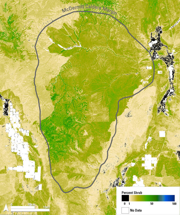
Shrub Distribution Over the McDermitt Caldera Region
Shrub Distribution Over the McDermitt Caldera RegionThis map shows 2024 shrub cover from the Rangeland Condition Monitoring Assessment and Projection (RCMAP) project across the McDermitt Caldera, outlined in gray, along the Nevada–Oregon border. Dark green areas indicate high shrub cover, typically found in riparian zones and at higher elevations.
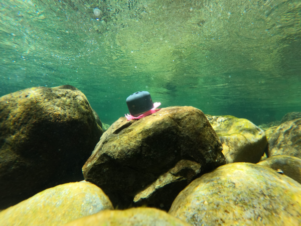
Temperature logger in Santiam River basin, Oregon
Temperature logger attached to submerged cobble in Quartzville Creek, OR. This logger was placed as part of an ongoing effort to retrieve continuous temperature data from rivers and tributaries within the Willamette River basin, OR.
Temperature logger attached to submerged cobble in Quartzville Creek, OR. This logger was placed as part of an ongoing effort to retrieve continuous temperature data from rivers and tributaries within the Willamette River basin, OR.
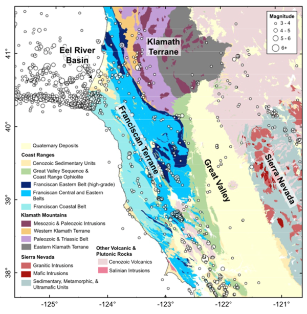
Map of location and magnitude of seismic events and rock types of the west coast of California and southern Oregon
Map of location and magnitude of seismic events and rock types of the west coast of California and southern OregonThis map, taken from a 2024 journal article by Furlong et al. 2024, shows the location and magnitude of seismic events (earthquakes) and rock type on a basemap of a portion of the west coast of North America.

Baby rough-skinned newt in a defensive posture
A young rough-skinned newt in a defensive posture known as "unkenreflex." Several amphibian species curl up their bodies to display their brightly colored bellies as a warning to predators that they are poisonous.
A young rough-skinned newt in a defensive posture known as "unkenreflex." Several amphibian species curl up their bodies to display their brightly colored bellies as a warning to predators that they are poisonous.

Map of earthquakes located at Newberry volcano from 2012 to 2024
Map of earthquakes located at Newberry volcano from 2012 to 2024Map of Newberry volcano shows location where earthquakes occurred during geothermal work in 2012 and 2014 (orange circles) and volcanic earthquakes that have occurred since 2011 (blue circles).

Ryan Byrne
This is a photograph of Ryan Byrne, a scientist at the Klamath Falls Field Station in Klamath Falls, OR. He is a part of the Western Fisheries Research Center.
This is a photograph of Ryan Byrne, a scientist at the Klamath Falls Field Station in Klamath Falls, OR. He is a part of the Western Fisheries Research Center.

Lower End of Fish Ladder at Keno Dam Looking Downstream
Lower End of Fish Ladder at Keno Dam Looking DownstreamThis is Keno Dam, in Klamath, OR. The Western Fisheries Research Center (WFRC) is doing work here to ensure proper fish passage is functioning and to provide science to help better address the water needs of the Klamath River Basin.

Fish Ladder at Keno Dam
The Western Fisheries Research Center (WFRC) is partnering with the U.S. Bureau of Reclamation to discuss ways to monitor fish passage at Keno Dam. With the recent removal of four mainstem dams along the Klamath River, Keno Dam now stands as the most downstream fish passage challenge , and the first major obstacle for migrating salmon returning upstream.
The Western Fisheries Research Center (WFRC) is partnering with the U.S. Bureau of Reclamation to discuss ways to monitor fish passage at Keno Dam. With the recent removal of four mainstem dams along the Klamath River, Keno Dam now stands as the most downstream fish passage challenge , and the first major obstacle for migrating salmon returning upstream.

Geomorphic map of Echo, Oregon
This geomorphic map of Echo, Oregon shows the town is built on valley bottom terrain. Other landforms such as slopes, fans, bedrock, etc. are delineated in the surrounding area. From https://www.usgs.gov/maps/geomorphic-map-umatilla-river-corridor-oregon.
This geomorphic map of Echo, Oregon shows the town is built on valley bottom terrain. Other landforms such as slopes, fans, bedrock, etc. are delineated in the surrounding area. From https://www.usgs.gov/maps/geomorphic-map-umatilla-river-corridor-oregon.
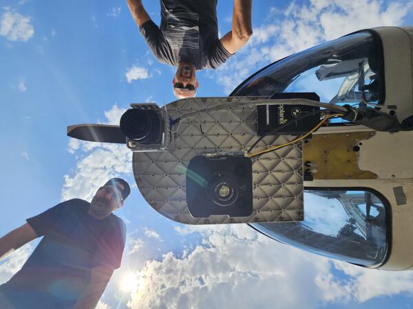
Underside of Bell Jet Helicopter with thermal infrared and true-color image sensors and JN and M.D.
Underside of Bell Jet Helicopter with thermal infrared and true-color image sensors and JN and M.D.Underside of Bell Jet Helicopter with thermal infrared and true-color image sensors and JN and M.D. The helicopter is used for airborne surveys of river reaches to capture temperature values of water-surfaces.

Juniper tree in the Stinkingwater Mountains of Oregon
Juniper tree in the Stinkingwater Mountains of OregonA tall, partially dead western juniper (Juniperus occidentalis) surrounded by smaller, dead juniper trees. Project ROAM (Rapid and Other Methods for Assessment and Monitoring) plots are sampled across a variety of rangeland ecosystems and treatment prescriptions, including juniper removal.
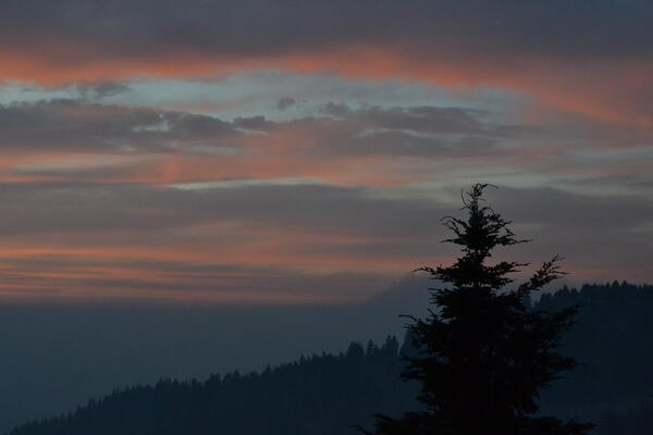
Sunset on Klamath Falls, OR
This is a photo of a sunset in August, 2024 in Klamath Falls, OR. The Western Fisheries Research Center (WFRC) conducts work on fish health and monitoring in this area.
This is a photo of a sunset in August, 2024 in Klamath Falls, OR. The Western Fisheries Research Center (WFRC) conducts work on fish health and monitoring in this area.

View of nose of Bell Jet Helicopter with a thermal infrared and true-color sensor co-mounted to the underside
View of nose of Bell Jet Helicopter with a thermal infrared and true-color sensor co-mounted to the undersideProfile view of a Bell Jet Helicopter with a thermal infrared and true-color sensor co-mounted to the underside of the nose. These sensors are used in airborne thermal infrared surveys for remotely sensing land/water surface temperature.

Eye Fluke Parasite in Klamath Sucker Eye
Fish health monitoring efforts in Upper Klamath Lake have revealed a high prevalence of warmwater pathogens. The fish health team is investigating parasites as a potential threat to the vulnerable sucker populations.
Fish health monitoring efforts in Upper Klamath Lake have revealed a high prevalence of warmwater pathogens. The fish health team is investigating parasites as a potential threat to the vulnerable sucker populations.

Shore of Lake Abert, Oregon
Lake Abert, Oregon is one of the 20 terminal lakes identified by USGS partners as priority ecosystems for study by the Saline Lakes Ecosystems IWAA.
By
Ecosystems Mission Area, Water Resources Mission Area, Forest and Rangeland Ecosystem Science Center, Fort Collins Science Center, Nevada Water Science Center, Oregon Water Science Center, Utah Water Science Center, Western Ecological Research Center (WERC), Saline Lake Ecosystems Integrated Water Availability Assessment

Goose Lake, Oregon-California
Goose Lake, on the Oregon-California border, is one of the 20 terminal lakes identified by USGS partners as priority ecosystems for study by the Saline Lakes Ecosystems IWAA.
By
Ecosystems Mission Area, Water Resources Mission Area, Species Management Research Program, Water Resources Research Act Program, Forest and Rangeland Ecosystem Science Center, Fort Collins Science Center, Nevada Water Science Center, Oregon Water Science Center, Utah Water Science Center, Western Ecological Research Center (WERC), Saline Lake Ecosystems Integrated Water Availability Assessment