Woods Hole Coastal and Marine Science Center Newsletter: June-July 2025
Our Science Stories
-
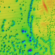
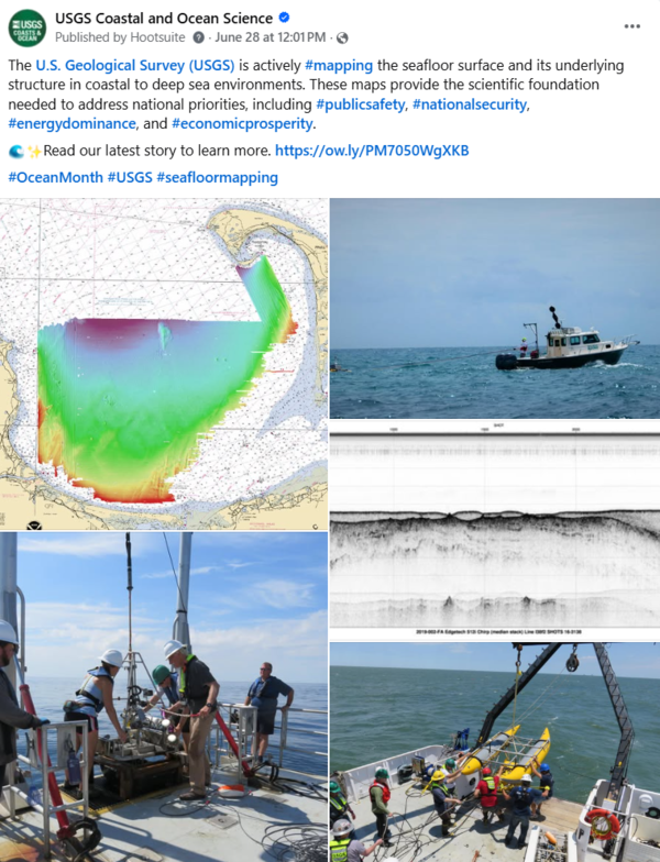
USGS Seafloor Mapping Provides the Scientific Foundation Needed to Address National Priorities USGS Seafloor Mapping Provides the Scientific Foundation Needed to Address National Priorities
Seafloor mapping provides the fundamental data needed to study a wide range of topics. The USGS is actively mapping the seafloor surface and its underlying structure in coastal to deep sea environments to address national priorities.
-
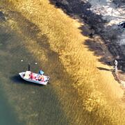
Helping Our Neighbors: USGS Surveys Primary Drinking Water Source for the Town of Falmouth Helping Our Neighbors: USGS Surveys Primary Drinking Water Source for the Town of Falmouth
USGS conducted a mapping survey of Long Pond in Falmouth, Massachusetts, at the request of the Town to determine the total water volume of the reservoir, as well as the water volumes available based on varying water surface elevations. Long Pond is Falmouth’s primary source of drinking water.
-
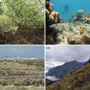
Ecological Thresholds, Abiotic Stress, and Climate Change: A Conceptual Framework Ecological Thresholds, Abiotic Stress, and Climate Change: A Conceptual Framework
As climate change accelerates, the risk of sudden, large-scale shifts in ecosystems is growing. A new USGS study examines the mechanisms behind these abrupt ecological transformations—known as threshold responses—and offers a roadmap for predicting where and when they might occur.ByEcosystems Mission Area, Natural Hazards Mission Area, Coastal and Marine Hazards and Resources Program, Great Lakes Science Center, Pacific Coastal and Marine Science Center, Southwest Biological Science Center, St. Petersburg Coastal and Marine Science Center, Western Ecological Research Center (WERC), Western Geographic Science Center, Wetland and Aquatic Research Center , Woods Hole Coastal and Marine Science Center
-

Sound Waves Newsletter: June-July 2025 Sound Waves Newsletter: June-July 2025
This Sound Waves issue includes stories about coastal change, how seafloor mapping addresses national priorities, surveying a drinking water supply, stories related to the USGS-led seafloor mapping expedition on the Aleutian Arc offshore Alaska, and more.
Social Media Corner
Some of our most popular posts from the past couple months.
Publications and Data Releases
Publications
Eagle, M.J., Kroeger, K.D., Pohlman, J., Tamborski, J.J., Wang, Z.A., Brooks, T.W., O'Keefe Suttles, J.A., and Mann, A.G., 2025, The δ13C signature of dissolved organic and inorganic carbon reveals complex carbon transformations within a salt marsh: JGR Biogeosciences, Volume 130, Issue 6, e2025JG008898, https://doi.org/10.1029/2025JG008898.
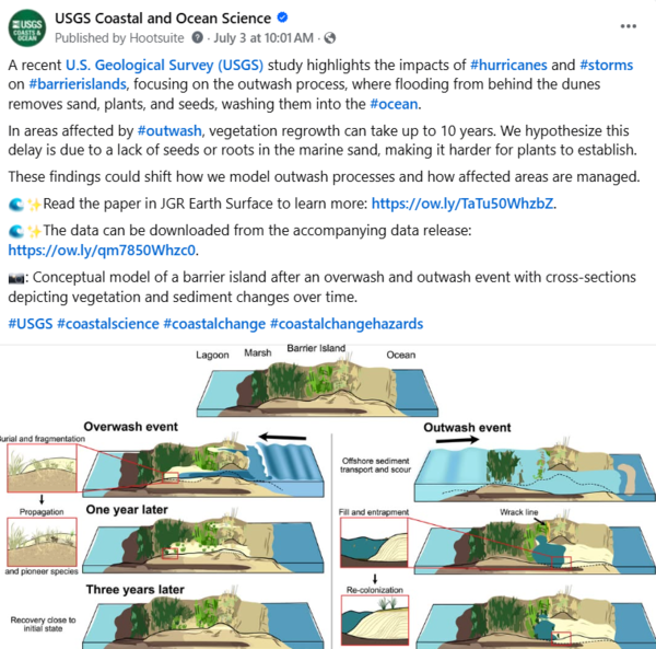
Over, J.R. and Sherwood, C.R., 2025, Outwash events inhibit vegetation recovery and prolong coastal vulnerability: JGR Earth Surface, Volume 130, Issue 6, e2024JF008162, https://doi.org/10.1029/2024JF008621.
Warner, J.C., Sherwood, C.R., Hegermiller, C.A., Defne, Z., Zambon, J.B., He, R., Xue, G., Bao, D., Yin, Dongxiao, and Moulton, M., 2025, Numerical simulation of sound-side barrier-island inundation and breaching during Hurricane Dorian (2019): JGR Earth Surface, Volume 130, Issue 6, e2025JF008309, https://doi.org/10.1029/2025JF008309.
Data Releases
Over, J.R., and Sherwood, C.R., 2025, Supplemental data for Over and Sherwood (2025), Washover and washout locations and landcover classifications after hurricanes Florence, Dorian, Harvey, Ike, and Sandy in North Carolina, Texas, and New York: U.S. Geological Survey data release, https://doi.org/10.5066/P1PGG57F.
Cramer, J.M., Brosnahan, S.M., Ackerman, S.D., Over, J.R., Millo, A., and Rheinhardt, R., 2025, Topographic data, aerial imagery, and GPS data collected during uncrewed aircraft system (UAS) operations at Sesuit Marsh, Dennis, Massachusetts, August 12, 2024: U.S. Geological Survey data release, https://doi.org/10.5066/P1EPMT7Y.
Kotowicz, D.M., Stoltz, A.D., and Woodard, N., 2025, Modeling marsh migration—User needs for decision-making collected in 2021 and 2023: U.S. Geological Survey data release, https://doi.org/10.5066/P13JMCBZ.
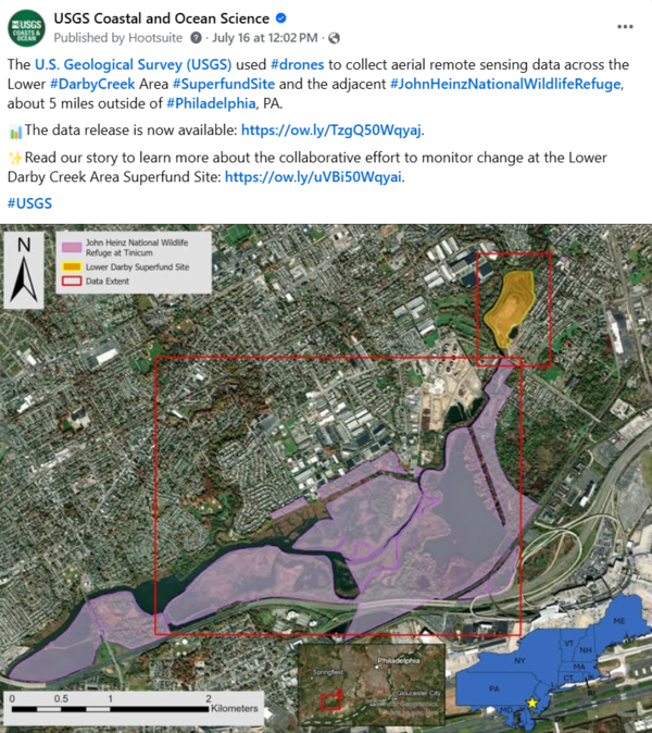
Cramer, J.M., Brosnahan, S.M., Ackerman, S.D., Over, J.R., Millo, A., Gazoorian, C.L., and Kelley, D.J., 2025, Topographic data, aerial imagery, and GPS data collected during uncrewed aircraft system (UAS) operations at Lower Darby Creek, Darby Township, Pennsylvania, March to August 2024: U.S. Geological Survey data release, https://doi.org/10.5066/P134HU3Y.
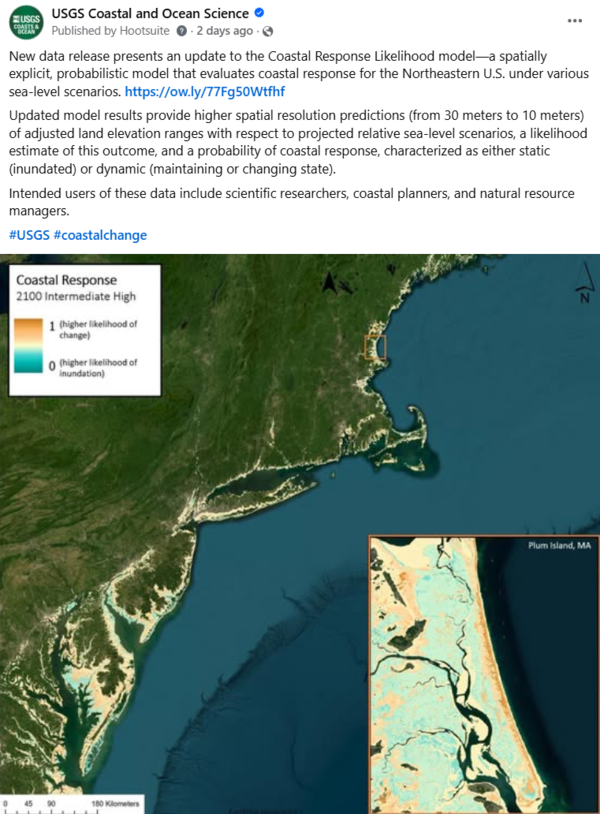
Bartlett, M.K., Heslin, J.L., Weber, K.M., and Lentz, E.E., 2025, Coastal landscape response to sea-level rise assessment for the northeastern United States: U.S. Geological Survey data release, https://doi.org/10.5066/P13JKJUT.
Fieldwork
Expedition in the Aleutian Arc Offshore Alaska
The USGS led an expedition in the Aleutian Arc off Alaska to provide critical information on energy resources, underwater earthquakes and other hazards, seafloor habitats, biological resources, and seabed minerals. USGS scientists joined the Bureau of Ocean Energy Management (BOEM), National Oceanic and Atmospheric Administration (NOAA), and university partners in characterizing benthic communities, including deep sea corals, hydrothermal vents, and gas seeps, as well as seamounts near volcanoes. This work will provide baseline biological, geological, and chemical information about the deepwater resources in the region to Federal, State, Tribal, and local communities and to private industry to support effective management. Initial project planning was conducted in collaboration with the Qawalangin Tribe of Unalaska and the Museum of the Aleutians, and in communication with the Akutan Village Council. USGS scientists engaged in educational outreach with Tribes and local community members before, during, and after the cruise. Visit the June-July 2025 Sound Waves newsletter to read several stories about this expedition.
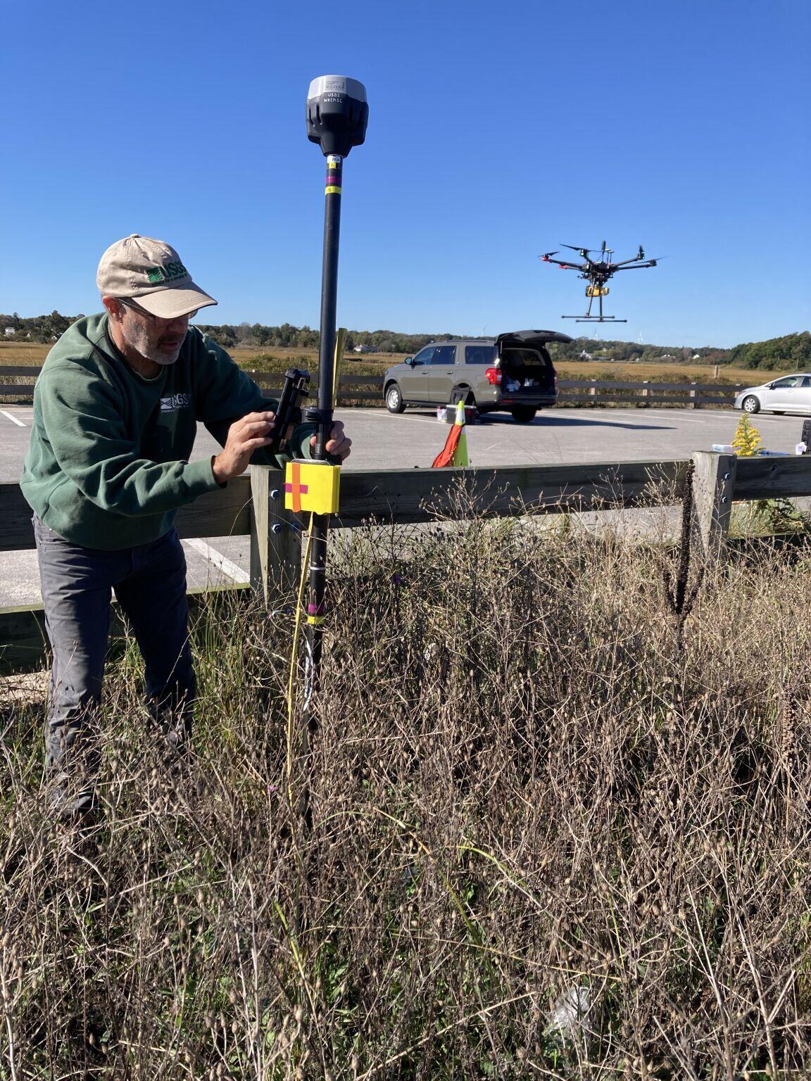
Collecting Shoreline and Volumetric Data in Sandwich, MA
From June through December, WHCMSC scientists are collecting shoreline and volumetric data at a beach in Sandwich, Massachusetts following a 2023 U.S. Army Corps of Engineers beach nourishment. The data will be useful for various purposes. Chris Sherwood is interested in comparing how the different measuring techniques work on different types of vegetation. Amy Farris wants to learn how beach slope varies over time, especially after beach nourishment, which will help us understand how effective shoreline positions derived from satellite images are at monitoring beaches after they have been nourished.
Outreach and Other Activities
2025 NRDAR Workshop Presentation
Neil Ganju gave a presentation titled, “Geospatial Metrics to Guide Restoration and Damage Assessments in Coastal Marshes and Beyond,” at the virtual 2025 National Natural Resource Damage Assessment and Restoration (NRDAR) Workshop. He received a personal thank you from the Office of Restoration and Damage Assessment for his participation and the value his knowledge and expertise adds to the Department of Interior. Visit the website to learn more about the NRDAR workshop.

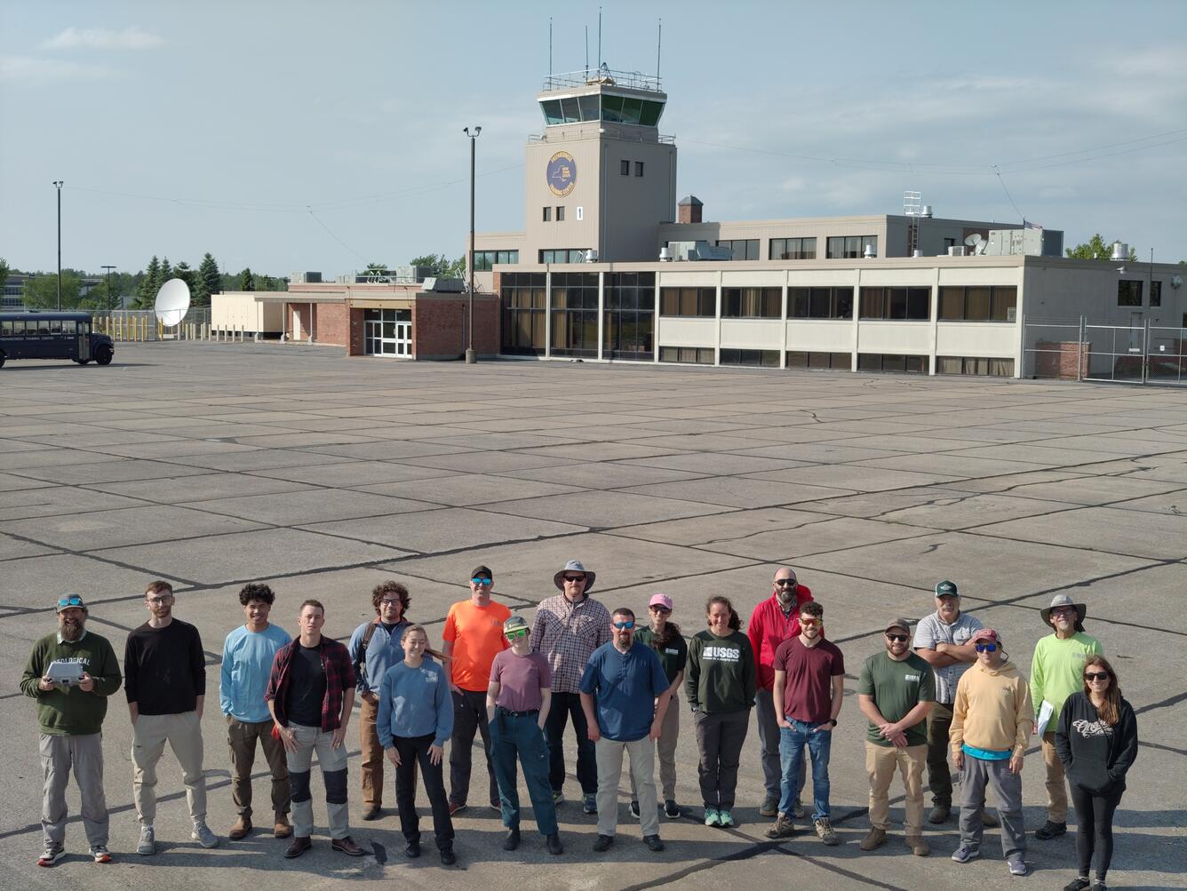
Drone Pilot Course in Upstate New York
An introductory course for small uncrewed aircraft system (sUAS) pilots was held at the New York State Emergency Preparedness Training Facility in Oriskany, New York. Instructors from across the country, including Sandy Brosnahan (lead instructor) and Seth Ackerman of the USGS WHCMSC, collaborated to deliver the training. The course was designed to prepare remote pilots to support emergency flood response efforts, with a focus on collecting Large-Scale Particle Imaging Velocimetry measurements at stream gauges. This remote sensing method enables high-water flood discharge data collection without putting personnel in potentially dangerous conditions. All course attendees earned a certification as new sUAS pilots under the Department of Interior.
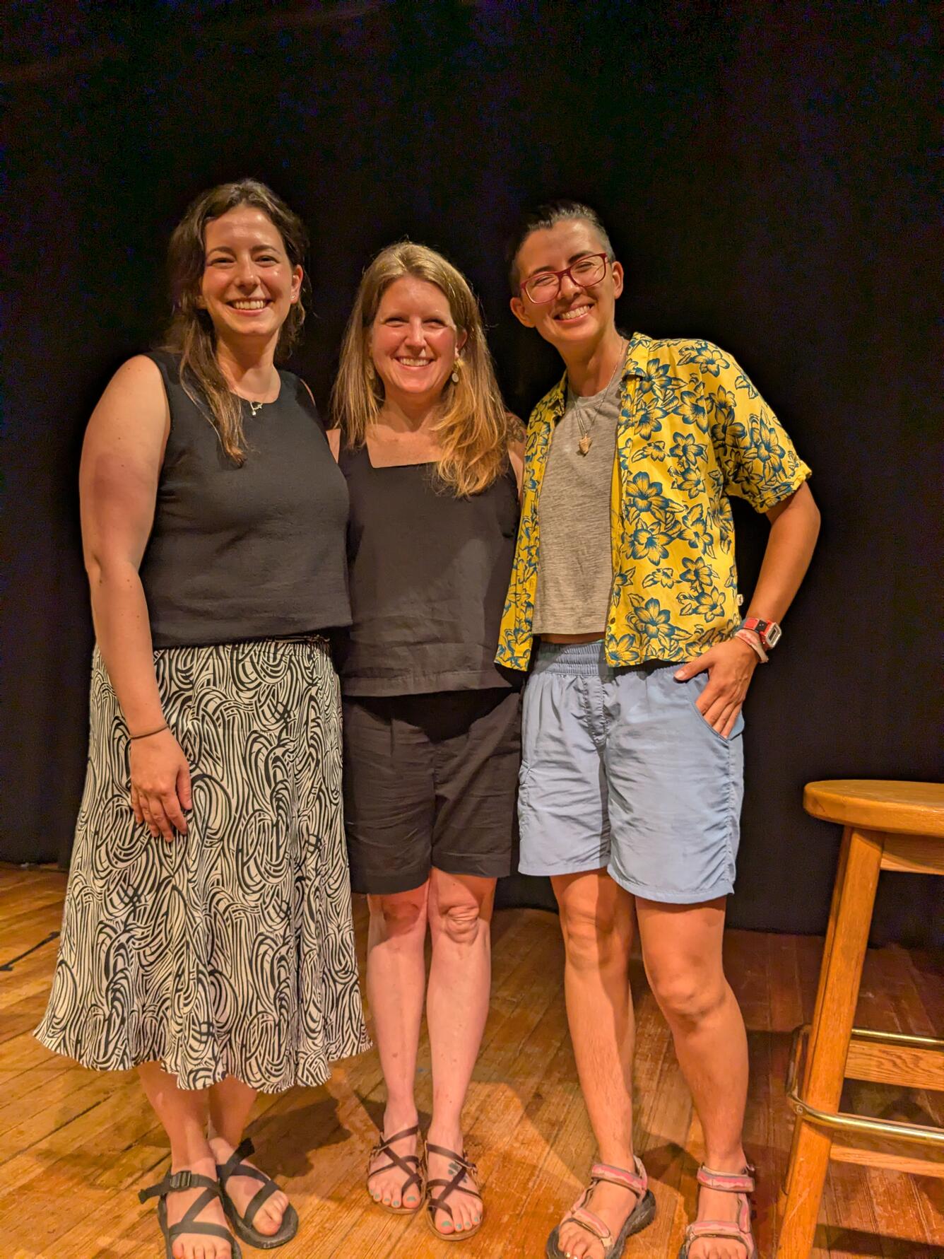
'Story Slam' Celebrating Science, Storytelling, and Community
Non-profit organizations Transom Story Lab and Atlantic Public Media hosted a weekend-long science storytelling workshop called "Making Waves." It was attended by 11 scientists from scientific institutions throughout Woods Hole, Massachusetts, including USGS scientists Jin-Si Over, Ellen Lalk, and Sara Zeigler. The scientists worked with the acclaimed director and producer of The Moth Radio Hour to develop personal, poignant stories. Sophie Crane, executive director of Transom, said that “This workshop is about helping scientists share not just what they do, but the inspiration and humanity fueling their labors, why it matters — and why it matters here, in this community.” Storytellers had the opportunity to share their stories with a live audience on June 24. Visit the website to learn more and listen to the stories shared.
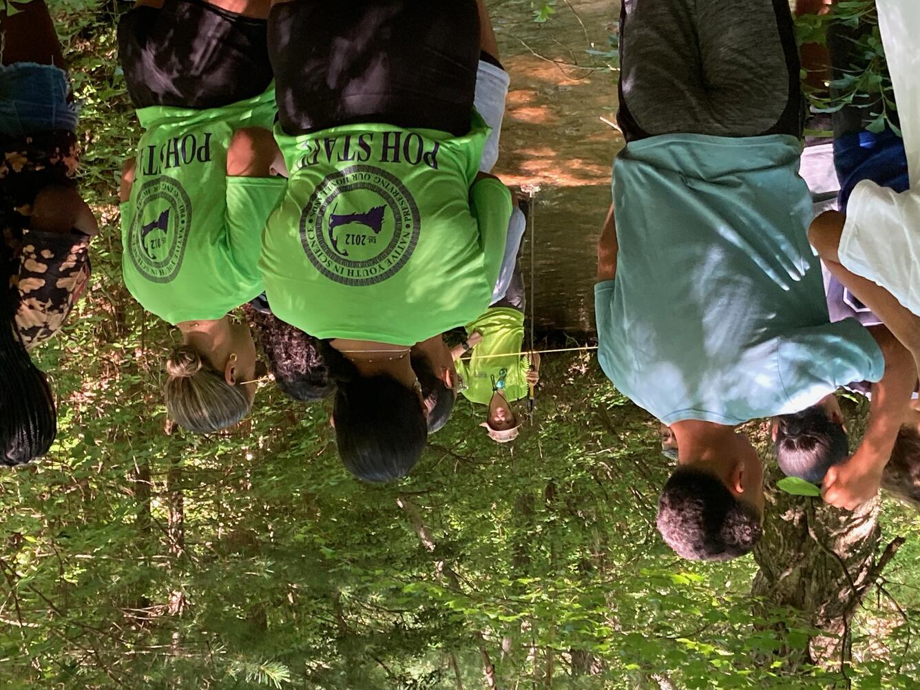
EPA/USGS Day of the 2025 Mashpee Wampanoag Tribe - Preserving Our Homelands Summer Camp
The Environmental Protection Agency (EPA) and USGS prepared four activities for the Preserving Our Homelands Summer Camp on July 22nd. EPA hosted an air quality monitoring activity that involved the campers conducting tests and participating in a guided discussion about factors contributing to air quality and its implications on people and habitat. They also hosted a water, algae, and macroinvertebrate sampling station. Wayne Baldwin (USGS) discussed Cape Cod glacial geology and highlighted some of the distinctly glacially derived geomorphologic features of the landscape. Mashpee Wampanoag Tribe elders contributed stories that highlighted the intimate tribal connections to their land and its unique features. Amanda Hartstein and Jason Sorenson (USGS) conducted a tour of a USGS stream gauge site on the Mashpee River, where they described its components, illustrated how it works, and discussed the importance of the data it captures. Jason also demonstrated how USGS hydrologists conduct water quality sampling, guided campers in making their own measurements, and led a group discussion on the importance of water quality.