Heavy spring rains and widespread flooding has killed more than 150 people and displaced thousands in Kenya this year.

Official websites use .gov
A .gov website belongs to an official government organization in the United States.
Secure .gov websites use HTTPS
A lock () or https:// means you’ve safely connected to the .gov website. Share sensitive information only on official, secure websites.
Peruse our selection of remote sensing and Earth science imagery below.

Heavy spring rains and widespread flooding has killed more than 150 people and displaced thousands in Kenya this year.
Heavy spring rains and widespread flooding has killed more than 150 people and displaced thousands in Kenya this year.

Seventeen rivers flow into the Bangweulu Wetlands in Zambia, but only one drains out. Green tendrils randomly sweep through the image, a landscape dominated by various grasslands, open water, and dense Papyrus grass and Phragmites reeds. The entire wetland covers an area about the size of Connecticut.
Seventeen rivers flow into the Bangweulu Wetlands in Zambia, but only one drains out. Green tendrils randomly sweep through the image, a landscape dominated by various grasslands, open water, and dense Papyrus grass and Phragmites reeds. The entire wetland covers an area about the size of Connecticut.

New fissures opened up on Hawaii’s Big Island in early May 2018, spouting lava that destroyed homes in the Leilani Estates neighborhood.
New fissures opened up on Hawaii’s Big Island in early May 2018, spouting lava that destroyed homes in the Leilani Estates neighborhood.

The 2018 fire season is already active in the western United States. One of the larger wildfires so far is the Rattlesnake Fire.
The 2018 fire season is already active in the western United States. One of the larger wildfires so far is the Rattlesnake Fire.

The Lake Eyre Basin is one of the driest places in Australia. But this image features a rare green flush to this otherwise parched landscape. Streams and creeks that drain into the basin are usually dry, but storms in March 2018 delivered water to these braided channels. By April, the floodwater had receded and left a green expanse behind.
The Lake Eyre Basin is one of the driest places in Australia. But this image features a rare green flush to this otherwise parched landscape. Streams and creeks that drain into the basin are usually dry, but storms in March 2018 delivered water to these braided channels. By April, the floodwater had receded and left a green expanse behind.

A group of second-graders from the Garretson School District in Garretson, South Dakota pose for a photo at the Earth Resources Observation and Science Center near Sioux Falls, SD.
A group of second-graders from the Garretson School District in Garretson, South Dakota pose for a photo at the Earth Resources Observation and Science Center near Sioux Falls, SD.

Decades of consistent data from Landsat help scientists monitor the growth of urban areas in a world where more than half of the population lives in cities.
Decades of consistent data from Landsat help scientists monitor the growth of urban areas in a world where more than half of the population lives in cities.

Near the Queen Fabiola Mountains, also called the Yamato Mountains, is a classic example of blue ice in Antarctica. Blue ice emerges where wind scours glaciers clean of snow and forms when air bubbles are squeezed out of layers of partially compacted snow left over from previous seasons. The ice appears blue because red and yellow wavelengths of light are absorbed.
Near the Queen Fabiola Mountains, also called the Yamato Mountains, is a classic example of blue ice in Antarctica. Blue ice emerges where wind scours glaciers clean of snow and forms when air bubbles are squeezed out of layers of partially compacted snow left over from previous seasons. The ice appears blue because red and yellow wavelengths of light are absorbed.

Images from the Advanced Spaceborne Thermal Emission and Reflection Radiometer (ASTER) onboard NASA's Terra satellite show how one area in South Korea transformed from mountainous forest to a world-class downhill skiing venue to get ready for the 2018 Winter Olympics.
Images from the Advanced Spaceborne Thermal Emission and Reflection Radiometer (ASTER) onboard NASA's Terra satellite show how one area in South Korea transformed from mountainous forest to a world-class downhill skiing venue to get ready for the 2018 Winter Olympics.

Volcán de Fuego in Guatemala erupted on January 31, 2018, and Landsat 8 acquired an image of the eruption a day later.
Volcán de Fuego in Guatemala erupted on January 31, 2018, and Landsat 8 acquired an image of the eruption a day later.

Landsat 7 satellite image from February 1, 2018, acquired on Landsat 7's 100,000th orbit.
Landsat 7 satellite image from February 1, 2018, acquired on Landsat 7's 100,000th orbit.

Water levels in large reservoirs in South Africa’s Western Cape province have been impacted by persistent drought in recent years. This Landsat 2014 image shows the Theewaterskloof reservoir, the largest in the province’s water supply system. In subsequent years, water levels have dropped significantly as seasonal rains have repeatedly failed.
Water levels in large reservoirs in South Africa’s Western Cape province have been impacted by persistent drought in recent years. This Landsat 2014 image shows the Theewaterskloof reservoir, the largest in the province’s water supply system. In subsequent years, water levels have dropped significantly as seasonal rains have repeatedly failed.

Ivanpah Playa Radiometric Calibration Site
Learn more about this Test Site at https://calval.cr.usgs.gov/apps/ivanpah.
Ivanpah Playa Radiometric Calibration Site
Learn more about this Test Site at https://calval.cr.usgs.gov/apps/ivanpah.

A three-year drought is threatening to cause city officials in Cape Town, South Africa, to shut off the tap water. The growing city of nearly 4 million relies mostly on reservoirs for its water supply. While drought is part of the cause of the current crisis, an increasing population is also straining water resources.
A three-year drought is threatening to cause city officials in Cape Town, South Africa, to shut off the tap water. The growing city of nearly 4 million relies mostly on reservoirs for its water supply. While drought is part of the cause of the current crisis, an increasing population is also straining water resources.

Over the past few years, black smoke has been seen in satellite images billowing from various locations in Iraq. As Iraqi forces drive ISIS away, the terrorist group has been setting oil wells on fire as it retreats.
Over the past few years, black smoke has been seen in satellite images billowing from various locations in Iraq. As Iraqi forces drive ISIS away, the terrorist group has been setting oil wells on fire as it retreats.

At least 300 active volcanoes dot the Kamchatka Peninsula, which lies along the geologically active Pacific Ring of Fire. Landsat 8 caught this plume of ash and smoke streaming from one of these volcanoes - Klyuchevskaya - on January 10, 2018.
At least 300 active volcanoes dot the Kamchatka Peninsula, which lies along the geologically active Pacific Ring of Fire. Landsat 8 caught this plume of ash and smoke streaming from one of these volcanoes - Klyuchevskaya - on January 10, 2018.

A volcanic landscape in the Tibesti Mountains of Chad shows some mysterious shapes. However, science can explain mysteries in satellite images. The octopus-shaped feature consists of ancient volcanic flows. In the crater below it, what looks like a face is bright salt deposits.
A volcanic landscape in the Tibesti Mountains of Chad shows some mysterious shapes. However, science can explain mysteries in satellite images. The octopus-shaped feature consists of ancient volcanic flows. In the crater below it, what looks like a face is bright salt deposits.

If you like being connected to the world everywhere you go with a smartphone or other device, then you have a desolate salt flat in northern Chile to thank.
If you like being connected to the world everywhere you go with a smartphone or other device, then you have a desolate salt flat in northern Chile to thank.

A massive iceberg broke off Pine Island Glacier, Antarctica, in September 2017. Instead of drifting out to sea after calving, sea ice impeded the iceberg’s movement, and it cracked up into countless pieces nearly on the spot. Even though it broke up relatively quickly for an iceberg, it is more of a slow-motion shattering.
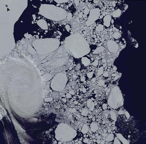
A massive iceberg broke off Pine Island Glacier, Antarctica, in September 2017. Instead of drifting out to sea after calving, sea ice impeded the iceberg’s movement, and it cracked up into countless pieces nearly on the spot. Even though it broke up relatively quickly for an iceberg, it is more of a slow-motion shattering.
This image of the Ross Archipelago near the McMurdo Station in Antarctica was acquired January 1, 2018, by Landsat 8, almost exactly a decade after USGS and NASA officials signed off on a Landsat Data Distribution Policy that made Landsat images free to the public.
This image of the Ross Archipelago near the McMurdo Station in Antarctica was acquired January 1, 2018, by Landsat 8, almost exactly a decade after USGS and NASA officials signed off on a Landsat Data Distribution Policy that made Landsat images free to the public.

This image of the Ross Archipelago near the McMurdo Station in Antarctica was acquired January 1, 2018, by Landsat 8, almost exactly a decade after USGS and NASA officials signed off on a Landsat Data Distribution Policy that made Landsat images free to the public.
This image of the Ross Archipelago near the McMurdo Station in Antarctica was acquired January 1, 2018, by Landsat 8, almost exactly a decade after USGS and NASA officials signed off on a Landsat Data Distribution Policy that made Landsat images free to the public.