This Lidar scan shows the South Dakota Capitol Building in Pierre, South Dakota.
The EROS Cal/Val Center of Excellence (ECCOE) provides system and data quality research in support of the USGS National 3D Elevation Program.

Official websites use .gov
A .gov website belongs to an official government organization in the United States.
Secure .gov websites use HTTPS
A lock () or https:// means you’ve safely connected to the .gov website. Share sensitive information only on official, secure websites.
Peruse our selection of remote sensing and Earth science imagery below.

This Lidar scan shows the South Dakota Capitol Building in Pierre, South Dakota.
The EROS Cal/Val Center of Excellence (ECCOE) provides system and data quality research in support of the USGS National 3D Elevation Program.
This Lidar scan shows the South Dakota Capitol Building in Pierre, South Dakota.
The EROS Cal/Val Center of Excellence (ECCOE) provides system and data quality research in support of the USGS National 3D Elevation Program.

Landsat 8 image of Manila Bay, captured on December 6, 2019, four days after the area was struck by Typhoon Kammuri.
Landsat 8 image of Manila Bay, captured on December 6, 2019, four days after the area was struck by Typhoon Kammuri.

The United Kingdom’s Solway Firth is show in these images comparing a natural color Landsat 8 Collection 2 Level-1 product (Bands 4,3,2) acquired on October 2, 2019 (left), and the corresponding Collection 2 Provisional Aquatic Reflectance science product using Rayleigh-corrected Reflectance (RHORC) Bands 4,3,2 (right).
The United Kingdom’s Solway Firth is show in these images comparing a natural color Landsat 8 Collection 2 Level-1 product (Bands 4,3,2) acquired on October 2, 2019 (left), and the corresponding Collection 2 Provisional Aquatic Reflectance science product using Rayleigh-corrected Reflectance (RHORC) Bands 4,3,2 (right).

Rupert Bay, an arm of James Bay, extends into Quebec, Canada. Many rivers carry sediment into the bay and combine with seawater coming in from the tide. A prominent sediment stream extends past Stag Island and a vortex curls off Stag Rock in the middle of the bay.
Rupert Bay, an arm of James Bay, extends into Quebec, Canada. Many rivers carry sediment into the bay and combine with seawater coming in from the tide. A prominent sediment stream extends past Stag Island and a vortex curls off Stag Rock in the middle of the bay.

Nature always displays vibrant colors. It is only a matter of time until you get the chance to witness its beauty. Even more difficult is capturing this beauty through the lens. Here, we see the magnificent beauty of the falls on the Big Sioux River, from which Sioux Falls, SD takes its name, showing the vibrant colors of nature just before sunset.
Nature always displays vibrant colors. It is only a matter of time until you get the chance to witness its beauty. Even more difficult is capturing this beauty through the lens. Here, we see the magnificent beauty of the falls on the Big Sioux River, from which Sioux Falls, SD takes its name, showing the vibrant colors of nature just before sunset.

An interactive display at the USGS Earth Resources Observation and Science Center highlighting land change research.
An interactive display at the USGS Earth Resources Observation and Science Center highlighting land change research.

Viewers look through several years of change in an interactive display at the USGS Earth Resources Observation and Science Center.
Viewers look through several years of change in an interactive display at the USGS Earth Resources Observation and Science Center.

Abnormally high spring rainfall and subsequent flooding in the Midwest in 2019 had a season-long impact on cropland production.
Abnormally high spring rainfall and subsequent flooding in the Midwest in 2019 had a season-long impact on cropland production.

Jebel Kissu, in northwestern Sudan, emerges abruptly like an island in the vast Sahara Desert. The plateau is the eroded remnant of a granite dome. The bright linear features are truck tracks, common in the Sahara where there are no paved roads.
Jebel Kissu, in northwestern Sudan, emerges abruptly like an island in the vast Sahara Desert. The plateau is the eroded remnant of a granite dome. The bright linear features are truck tracks, common in the Sahara where there are no paved roads.

The high-water marks set by the Big Sioux River in cities across southeastern South Dakota have threatened to overtake records set 50 years ago, when the Army Corps of Engineers led missions to document the damage through hundreds of aerial photographs.
The high-water marks set by the Big Sioux River in cities across southeastern South Dakota have threatened to overtake records set 50 years ago, when the Army Corps of Engineers led missions to document the damage through hundreds of aerial photographs.

Landsat 8 image of Kandahar, Afghanistan on March 3, 2019, rendered with bands 7, 5, and 1 of the satellite's Operational Land Imager.
Landsat 8 image of Kandahar, Afghanistan on March 3, 2019, rendered with bands 7, 5, and 1 of the satellite's Operational Land Imager.

A bit of blue cubism in southern Uzbekistan highlights the intensive irrigation that is common along rivers that flow into the Aral Sea. However, so much water is used for irrigation that very little actually reaches the Aral Sea.
A bit of blue cubism in southern Uzbekistan highlights the intensive irrigation that is common along rivers that flow into the Aral Sea. However, so much water is used for irrigation that very little actually reaches the Aral Sea.

Water from the Balkh River fans out into an agricultural area toward an arid region in northern Afghanistan, near the border with Uzbekistan and Turkmenistan. Part of an ancient region called Bactria, extensive irrigation produces melons, almonds, apricots, and grains. Mazar-e Sharif is the urban area that dominates the lower right corner of the image.
Water from the Balkh River fans out into an agricultural area toward an arid region in northern Afghanistan, near the border with Uzbekistan and Turkmenistan. Part of an ancient region called Bactria, extensive irrigation produces melons, almonds, apricots, and grains. Mazar-e Sharif is the urban area that dominates the lower right corner of the image.
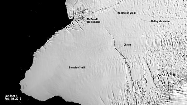
Black and white Landsat 8 image of Antarctica's Brunt Ice Shelf (Band 8), captured on Feb. 19, 2019.
Black and white Landsat 8 image of Antarctica's Brunt Ice Shelf (Band 8), captured on Feb. 19, 2019.

USGS EROS contractor Minsu Kim, left, and USGS Scientist Jeffrey Danielson stand with a GPS device in northern Idaho, where they were part of a research project to conduct topobathymetric research along the Kootenai River of northern Idaho.
USGS EROS contractor Minsu Kim, left, and USGS Scientist Jeffrey Danielson stand with a GPS device in northern Idaho, where they were part of a research project to conduct topobathymetric research along the Kootenai River of northern Idaho.

This natural landscape might appear more like a medical illustration of itchy nerve endings. In Western Sahara, Africa, an intense network of wadis drains toward the west, eventually reaching the Atlantic Ocean. These drainage courses are almost always dry in this remote part of the Sahara Desert.
This natural landscape might appear more like a medical illustration of itchy nerve endings. In Western Sahara, Africa, an intense network of wadis drains toward the west, eventually reaching the Atlantic Ocean. These drainage courses are almost always dry in this remote part of the Sahara Desert.

Rock folding on a tectonic scale occurred in northwestern Africa. These motley ribbons dancing across the desert in Morocco are folds caused by the prolonged collision of tectonic plates. The long continuous line is Jbel Ouarkziz, a ridge that rises 200–300 meters above the valley floors.
Rock folding on a tectonic scale occurred in northwestern Africa. These motley ribbons dancing across the desert in Morocco are folds caused by the prolonged collision of tectonic plates. The long continuous line is Jbel Ouarkziz, a ridge that rises 200–300 meters above the valley floors.
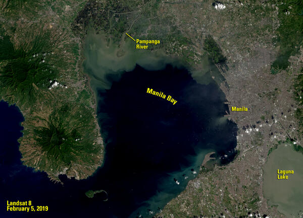
Landsat 8 image of Manila Bay, captured on February 5, 2019
Landsat 8 image of Manila Bay, captured on February 5, 2019

Map of Alaska showing probability (%) of change occurrence. Insets show fire boundaries from the Bureau of Land Management (BLM) Large Fire Database and Landsat 8 imagery (bottom right; 2016) north of Fairbanks, Alaska.
Map of Alaska showing probability (%) of change occurrence. Insets show fire boundaries from the Bureau of Land Management (BLM) Large Fire Database and Landsat 8 imagery (bottom right; 2016) north of Fairbanks, Alaska.

Modern paleontology began with the 1858 discovery by William Parker Foulke at Haddonfield, New Jersey of the nearly complete skeleton of a dinosaur called Hadrosaurus.
Capital Trenton
Image Source Landsat 8
Population 9,288,994
Modern paleontology began with the 1858 discovery by William Parker Foulke at Haddonfield, New Jersey of the nearly complete skeleton of a dinosaur called Hadrosaurus.
Capital Trenton
Image Source Landsat 8
Population 9,288,994
