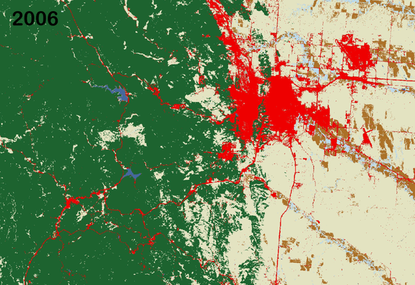
Australia is the smallest, and flattest, of all the continents. Its surface details are largely the result of erosion. Many rivers drain into the continent's harsh, arid interior, where they terminate in salt lakes that are dry for most of the year.
Images
Peruse our selection of remote sensing and Earth science imagery below.
Australia is the smallest, and flattest, of all the continents. Its surface details are largely the result of erosion. Many rivers drain into the continent's harsh, arid interior, where they terminate in salt lakes that are dry for most of the year.
The MacDonnell Ranges are a band of mountains spanning Australia's arid interior. Only a portion of the Ranges can be seen in this image.
Surrounded by sand dunes, Lake Disappointment is an ephemeral salt lake in one of the most remote areas of Western Australia. An early explorer supposedly named the lake in 1897 after following a number of creeks that he thought would lead to a large lake; they did, but the lake's extremely salty water was not drinkable.
Africa, the second largest continent, is a mix of steamy rainforests, vast grasslands, and arid deserts. It has no long mountain ranges, but is home to the world's largest hot desert, the Sahara, and its longest river, the Nile. The featured area is the central South Atlantic coastal region of Namibia, including the cities of Walvis Bay and Windhoek.
Snow-capped Colima Volcano, the most active volcano in Mexico, rises abruptly from the surrounding landscape in the state of Jalisco. Colima is actually a melding of two volcanoes, the older Nevado de Colima to the north and the younger, historically active Volcan de Colima to the south. Legend has it that gods sit atop the volcano on thrones of fire and ice.
Operations at the Donnell Fire in Stanislaus National Forest, California
Operations at the Donnell Fire in Stanislaus National Forest, CaliforniaUSDA Forest Service and California state firefighters work together in a night operation to push back a fire line at the Donnell Fire in Stanislaus National Forest, California. Forest Service photo by Cecilio Ricardo
Landsat 5 captured this image of the Tampa Bay, Florida area on March 22, 1991.
Bands 7,2,1
Image processed at Center for Coastal Geology, St. Petersburg, Florida.
Landsat 5 captured this image of the Tampa Bay, Florida area on March 22, 1991.
Bands 7,2,1
Image processed at Center for Coastal Geology, St. Petersburg, Florida.
The Landsat archive has added its 8 millionth scene. This stunning image was captured by Landsat 8 on July 28, 2018. It shows the coastline of Nordaustlandet, the second-largest island in Norway’s Svalbard archipelago.
Appearing as if an artist imitating Jackson Pollock had randomly spurted ink onto the canvas, this image shows swirling ice in the Foxe Basin of northern Canada. Even though the image is from late July, there was still ice floating in the water this far north.
Resembling choppy waters in a rough sea, this image is an infrared exposition of a sand sea in Namibia. Sand dunes surround a crescent-shaped rocky hill. This inselberg is hard rock that resisted the erosion that took place over time around it. The inselberg disrupts the deposition of sand, changing the dune pattern.
One glacier on Russian islands in the Arctic Ocean surprised scientists with its rapid change. After decades of normal, slow movement, a glacier draining Vavilov Ice Cap sprang forward, accelerating rapidly after 2013. This fast movement is extremely rare for cold-based glaciers. In 5 years, the ice tongue doubled in size.
This ASTER image from May 22, 2018, of an eruption at Kilauea in Hawaii displays vegetation in red, clouds in white and the hot lava flows, detected by ASTER's thermal infrared channels, overlaid in yellow. Lava flows from the eruption had reached the ocean, and the combination of molten lava and seawater produced clouds of noxious gases, such as hydrogen sulfide.
Heavy spring rains and widespread flooding has killed more than 150 people and displaced thousands in Kenya this year.
Seventeen rivers flow into the Bangweulu Wetlands in Zambia, but only one drains out. Green tendrils randomly sweep through the image, a landscape dominated by various grasslands, open water, and dense Papyrus grass and Phragmites reeds. The entire wetland covers an area about the size of Connecticut.
A History of Lava Flows at Hawaii’s Kilauea Volcano
A History of Lava Flows at Hawaii’s Kilauea VolcanoNew fissures opened up on Hawaii’s Big Island in early May 2018, spouting lava that destroyed homes in the Leilani Estates neighborhood.
A History of Lava Flows at Hawaii’s Kilauea Volcano
A History of Lava Flows at Hawaii’s Kilauea VolcanoNew fissures opened up on Hawaii’s Big Island in early May 2018, spouting lava that destroyed homes in the Leilani Estates neighborhood.
The 2018 fire season is already active in the western United States. One of the larger wildfires so far is the Rattlesnake Fire.
The Lake Eyre Basin is one of the driest places in Australia. But this image features a rare green flush to this otherwise parched landscape. Streams and creeks that drain into the basin are usually dry, but storms in March 2018 delivered water to these braided channels. By April, the floodwater had receded and left a green expanse behind.
A group of second-graders from the Garretson School District in Garretson, South Dakota pose for a photo at the Earth Resources Observation and Science Center near Sioux Falls, SD.
Decades of consistent data from Landsat help scientists monitor the growth of urban areas in a world where more than half of the population lives in cities.
Near the Queen Fabiola Mountains, also called the Yamato Mountains, is a classic example of blue ice in Antarctica. Blue ice emerges where wind scours glaciers clean of snow and forms when air bubbles are squeezed out of layers of partially compacted snow left over from previous seasons. The ice appears blue because red and yellow wavelengths of light are absorbed.
Images from the Advanced Spaceborne Thermal Emission and Reflection Radiometer (ASTER) onboard NASA's Terra satellite show how one area in South Korea transformed from mountainous forest to a world-class downhill skiing venue to get ready for the 2018 Winter Olympics.