U.S. flag

An official website of the United States government

Images

Peruse our selection of remote sensing and Earth science imagery below.

Filter Total Items: 880
Landsat 8 image of the Massachusetts coast, showing Cape Cod and Plymouth
Landsat 8 Image of the Massachusetts Coast

Landsat 8 image of the Massachusetts Coast, showing Boston, Plymouth, and Cape Cod.

Published on social media on November 28, 2024, for Thanksgiving.

Mosaic of two different Landsat 8 images:
Image dates: November 8 and 17, 2024
Path 11, Row 31 and Path 12, Row 31 

Landsat 8 image of the Massachusetts Coast, showing Boston, Plymouth, and Cape Cod.

Published on social media on November 28, 2024, for Thanksgiving.

Mosaic of two different Landsat 8 images:
Image dates: November 8 and 17, 2024
Path 11, Row 31 and Path 12, Row 31 

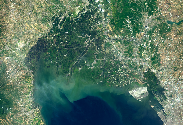
Landsat image of Pampanga River Delta
Pampanga River Delta

This Landsat 8 image shows the Pampanga River Delta and Manila Bay on March 6, 2024.

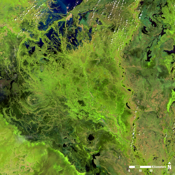
Landsat 8 image of South Sudan, showing portions of the states of Unity, Jonglei, and Warrup.
Landsat 8 image of South Sudan

Landsat 8 image of South Sudan, showing portions of the states of Unity, Jonglei, and Warrup. 

Image date: October 22, 2024
Path 174, Row 54
Band combination: 654

Landsat 8 image of South Sudan, showing portions of the states of Unity, Jonglei, and Warrup. 

Image date: October 22, 2024
Path 174, Row 54
Band combination: 654

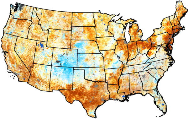
QuickDRI Map of United States showing the moisture and drought conditions for November 10, 2024.
QuickDRI Map of United States

This QuickDRI map shows the moisture and drought conditions for November 10, 2024.

Visit https://quickdri.unl.edu/data/weekly_maps/png/20241110/qdri_20241110_conus_text.png to view the full image, legend, and cooperators. 

infrared Landsat 8 imagery of Lake Manicouagan, from 2024
Lake Manicouagan, 2024 (Landsat 8 infrared imagery)

A large, round lake in Quebec, Canada, highlights the geography of an ancient impact crater. In the late Triassic Period, a 3 mile wide meteorite struck northern Pangea at over 30,000 miles per hour. The resulting crater is now 214 million years old, but the dramatic circular lake visible in 2024 Landsat imagery is a surprisingly recent feature.

A large, round lake in Quebec, Canada, highlights the geography of an ancient impact crater. In the late Triassic Period, a 3 mile wide meteorite struck northern Pangea at over 30,000 miles per hour. The resulting crater is now 214 million years old, but the dramatic circular lake visible in 2024 Landsat imagery is a surprisingly recent feature.

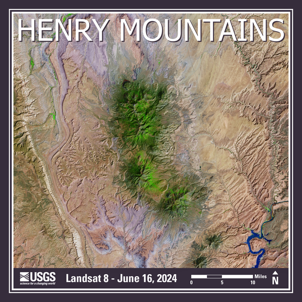
Landsat 8 image from June 16, 2024 or the Henry Mountains in southeastern Utah
Landsat 8 Image of the Henry Mountains in Utah

Landsat 8 image of the Henry Mountains in southeastern Utah. 

Published on social media on November 7, 2024.

Mosaic of two different Landsat 8 images:
Image date: June 16, 2024
Path 37, Row 33 and Path 37, Row 34

Landsat 8 image of the Henry Mountains in southeastern Utah. 

Published on social media on November 7, 2024.

Mosaic of two different Landsat 8 images:
Image date: June 16, 2024
Path 37, Row 33 and Path 37, Row 34

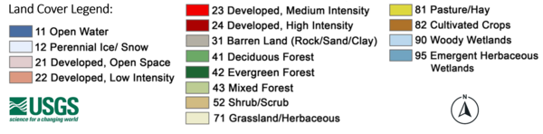
List of 16 land cover class labels, each corresponding with a different color in a box beside it
Annual National Land Cover Database (NLCD) legend

The legend for the Annual National Land Cover Database (NLCD) contains 16 classes of land cover. Annual NLCD is produced by the USGS Earth Resources Observation and Science (EROS) Center.

The legend for the Annual National Land Cover Database (NLCD) contains 16 classes of land cover. Annual NLCD is produced by the USGS Earth Resources Observation and Science (EROS) Center.

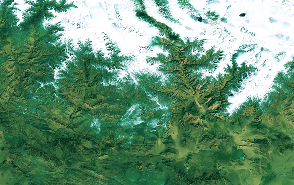
Landsat 9 image of the China-Mongolia border, showing parts of the autonomous region of Xinjiang and Khovd Province
Landsat 9 Image of China-Mongolia Border

Landsat 9 image of the China-Mongolia border, showing parts of the autonomous region of Xinjiang, China, and Khovd Province, Mongolia.

Image date: October 23, 2024
Path 141, Row 28

Landsat 9 image of the China-Mongolia border, showing parts of the autonomous region of Xinjiang, China, and Khovd Province, Mongolia.

Image date: October 23, 2024
Path 141, Row 28

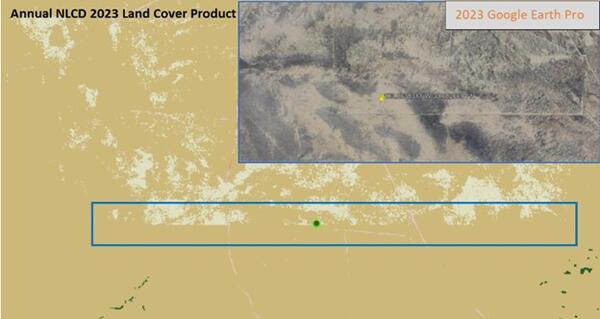
A graphic depicting the blockiness or seamlines in the Annual NLCD product.
Shrubs/Grassland Classification Blockiness

Desert in the Southwest showing “blockiness” between shrubland and grassland in Annual NLCD land cover.

An image of a generic user guide
Generic User Guide
Generic User Guide
Generic User Guide

A graphic to be used as a general illustration of user manual to be used as in the background.

A graphic to be used as a general illustration of user manual to be used as in the background.

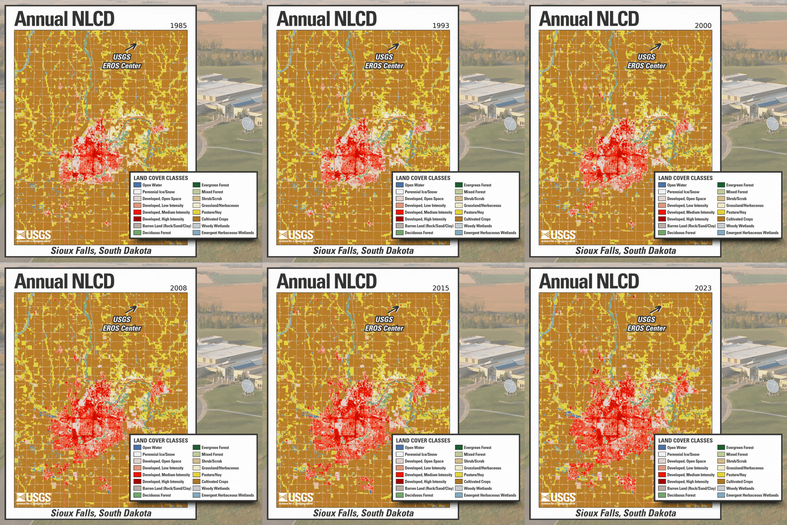
Annual NLCD animation of the Sioux Falls areas, showing the location of the USGS EROS Center
Annual NLCD Animation for Sioux Falls, South Dakota

Annual NLCD Animation for Sioux Falls, South Dakota. Annual NLCD is a new generation of land cover mapping that offers annual land cover and land change science products nationwide with nearly four decades of data. Learn more here: https://usgs.gov/annualnlcd

Annual NLCD Animation for Sioux Falls, South Dakota. Annual NLCD is a new generation of land cover mapping that offers annual land cover and land change science products nationwide with nearly four decades of data. Learn more here: https://usgs.gov/annualnlcd

Annual NLCD Animation for the Sioux Falls, South Dakota, area, showing a map legend and the location of the USGS EROS Center
Annual NLCD Animation for Sioux Falls, South Dakota, with Legend

Annual NLCD Animation for Sioux Falls, South Dakota, with photo of the USGS EROS Center in the background. Annual NLCD is a new generation of land cover mapping that offers annual land cover and land change science products nationwide with nearly four decades of data. Learn more here: https://usgs.gov/annualnlcd

Annual NLCD Animation for Sioux Falls, South Dakota, with photo of the USGS EROS Center in the background. Annual NLCD is a new generation of land cover mapping that offers annual land cover and land change science products nationwide with nearly four decades of data. Learn more here: https://usgs.gov/annualnlcd

A graphic show a pixelated water body that appears in the Annual NLCD
Pixelated Water Bodies

Lake Superior water body showing pixelated land cover layers over the water that should just be water.

Lake Superior water body showing pixelated land cover layers over the water that should just be water.

Annual NLCD (1985-2023) animation for the Great Salt Lake and Salt Lake Valley in Utah
Annual NLCD (1985-2023) Animation for the Great Salt Lake and Salt Lake Valley, Utah

Annual NLCD is a new generation of land cover mapping that offers annual land cover and land change science products nationwide with nearly four decades of data. Learn more here: https://usgs.gov/annualnlcd

Cross section of the 2023 Annual NLCD for the conterminous United States
Annual NLCD (2023) Cross Section of the Conterminous United States

Annual NLCD is a new generation of land cover mapping that offers annual land cover and land change science products nationwide with nearly four decades of data. Learn more here: https://usgs.gov/annualnlcd

A image of a simple "Newsletter" logo
Newsletter Logo
Newsletter Logo
Newsletter Logo

A simple "Newsletter" logo that can be utilized for social media links. Created for the Annual NLCD website.

A simple "Newsletter" logo that can be utilized for social media links. Created for the Annual NLCD website.

Annual NLCD (2023) for the conterminous United States, showing different major land cover types in the background
Annual NLCD (2023) for the Conterminous United States

Annual NLCD is a new generation of land cover mapping that offers annual land cover and land change science products nationwide with nearly four decades of data. Learn more here: https://usgs.gov/annualnlcd

Annual NLCD is a new generation of land cover mapping that offers annual land cover and land change science products nationwide with nearly four decades of data. Learn more here: https://usgs.gov/annualnlcd

Logos for United States agencies
LANDFIRE Partner Logos

LANDFIRE partner logos: Department of the Interior (DOI), Department of Agriculture (USDA), U.S. Geological Survey (USGS), U.S. Forest Service (USFS), and The Nature Conservancy

LANDFIRE partner logos: Department of the Interior (DOI), Department of Agriculture (USDA), U.S. Geological Survey (USGS), U.S. Forest Service (USFS), and The Nature Conservancy

A satellite picture of a lake with an algae swirl
Pyramid Lake in Nevada with Algal Bloom

Pyramid Lake is one of the largest natural lakes in the state of Nevada, covering an area of about 188 square miles (487 square kilometers). Located entirely within the Pyramid Lake Paiute Tribe Reservation on the western margin of the Great Basin Desert, this deep terminal lake is widely regarded as a world class fishery.

Pyramid Lake is one of the largest natural lakes in the state of Nevada, covering an area of about 188 square miles (487 square kilometers). Located entirely within the Pyramid Lake Paiute Tribe Reservation on the western margin of the Great Basin Desert, this deep terminal lake is widely regarded as a world class fishery.

Animation of Landsat 7 Images of Las Vegas, 1999-2024
Landsat 7 Images of Las Vegas, 1999-2024

Las Vegas, Nevada and the area surrounding has been and remains a popular region of interest when showcasing urban growth and land change using Landsat sensors.  

Las Vegas, Nevada and the area surrounding has been and remains a popular region of interest when showcasing urban growth and land change using Landsat sensors.  

Satellite image of an algae bloom on a lake
Landsat 9 image of eutrophication in Lake Thompson, South Dakota

A September 20, 2024, Landsat 9 satellite image of eutrophication in Lake Thompson, South Dakota. Eutrophication because of phosphate fertilizer use is probably one of the most notable impacts on the environment, society and the economy.

A September 20, 2024, Landsat 9 satellite image of eutrophication in Lake Thompson, South Dakota. Eutrophication because of phosphate fertilizer use is probably one of the most notable impacts on the environment, society and the economy.

Was this page helpful?