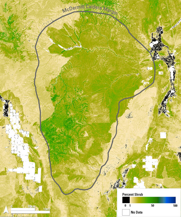
Landsat 8 image of Lake Thompson in South Dakota, showing a November algal bloom.
Image date: November 22, 2024
Path 30, Row 29
Band combinations: 654 (false color) to show the algal bloom, and then blended with 432 (natural color) to show the snow.
An official website of the United States government
Here's how you know
Official websites use .gov
A .gov website belongs to an official government organization in the United States.
Secure .gov websites use HTTPS
A lock () or https:// means you’ve safely connected to the .gov website. Share sensitive information only on official, secure websites.
Peruse our selection of remote sensing and Earth science imagery below.
Landsat 8 image of Lake Thompson in South Dakota, showing a November algal bloom.
Image date: November 22, 2024
Path 30, Row 29
Band combinations: 654 (false color) to show the algal bloom, and then blended with 432 (natural color) to show the snow.
Landsat 8 image of Lake Thompson in South Dakota, showing a November algal bloom.
Image date: November 22, 2024
Path 30, Row 29
Band combinations: 654 (false color) to show the algal bloom, and then blended with 432 (natural color) to show the snow.
Thumbnail image for video: 1 Hour of Earth From Above: Relaxing Landsat Satellite Imagery
Watch here: https://eros.usgs.gov/media-gallery/video-landsat/landsat-1-hour-of-ima…
Thumbnail image for video: 1 Hour of Earth From Above: Relaxing Landsat Satellite Imagery
Watch here: https://eros.usgs.gov/media-gallery/video-landsat/landsat-1-hour-of-ima…
Annual National Land Cover Database (NLCD) 2023 Land Cover in central Florida, with black lines representing railroads that crisscross the region. Railroads are integral in the phosphate mining process.
Annual National Land Cover Database image of Land Cover for Bone Valley, Florida, in 2023. Barren land cover (gray) and ponded water (dark blue) are typical of an active mine. Natural vegetation includes grassland (light tan), pasture/hay (yellow), wetland (light blue colors) and shrubland (dark tan). Urban areas are shown in shades of red.
Annual National Land Cover Database image of Land Cover for Bone Valley, Florida, in 1985. Barren land cover (gray) and ponded water (dark blue) are typical of an active mine. Natural vegetation includes grassland (light tan), pasture/hay (yellow), wetland (light blue colors) and shrubland (dark tan). Urban areas are shown in shades of red.
Animations of land cover change using Annual National Land Cover Database (NLCD) land cover (on the left) and Landsat true-color images (on the right). Changes to the landscape can be seen over the 38 years from 1985 to 2023.
Animations of land cover change using Annual National Land Cover Database (NLCD) land cover (on the left) and Landsat true-color images (on the right). Changes to the landscape can be seen over the 38 years from 1985 to 2023. This phosphate mine in Hamilton County, in northern Florida, expands in all directions over time, changing land cover from year to year.
This Landsat 9 image shows the Washington D.C. area on August 1, 2024. The image was created using Bands 6,5,4 and was then sharpened using the panchromatic band (Band 8) which has a higher resolution than the other bands (15 meters compared to 30 meters).
Path 15 Row 33
This Landsat 9 image shows the Washington D.C. area on August 1, 2024. The image was created using Bands 6,5,4 and was then sharpened using the panchromatic band (Band 8) which has a higher resolution than the other bands (15 meters compared to 30 meters).
Path 15 Row 33
Landsat 8 image of the Massachusetts Coast, showing Boston, Plymouth, and Cape Cod.
Published on social media on November 28, 2024, for Thanksgiving.
Mosaic of two different Landsat 8 images:
Image dates: November 8 and 17, 2024
Path 11, Row 31 and Path 12, Row 31
Landsat 8 image of the Massachusetts Coast, showing Boston, Plymouth, and Cape Cod.
Published on social media on November 28, 2024, for Thanksgiving.
Mosaic of two different Landsat 8 images:
Image dates: November 8 and 17, 2024
Path 11, Row 31 and Path 12, Row 31
Landsat 8 image of South Sudan, showing portions of the states of Unity, Jonglei, and Warrup.
Image date: October 22, 2024
Path 174, Row 54
Band combination: 654
Landsat 8 image of South Sudan, showing portions of the states of Unity, Jonglei, and Warrup.
Image date: October 22, 2024
Path 174, Row 54
Band combination: 654
This QuickDRI map shows the moisture and drought conditions for November 10, 2024.
Visit https://quickdri.unl.edu/data/weekly_maps/png/20241110/qdri_20241110_conus_text.png to view the full image, legend, and cooperators.
This QuickDRI map shows the moisture and drought conditions for November 10, 2024.
Visit https://quickdri.unl.edu/data/weekly_maps/png/20241110/qdri_20241110_conus_text.png to view the full image, legend, and cooperators.
Landsat 8 image of the Henry Mountains in southeastern Utah.
Published on social media on November 7, 2024.
Mosaic of two different Landsat 8 images:
Image date: June 16, 2024
Path 37, Row 33 and Path 37, Row 34
Landsat 8 image of the Henry Mountains in southeastern Utah.
Published on social media on November 7, 2024.
Mosaic of two different Landsat 8 images:
Image date: June 16, 2024
Path 37, Row 33 and Path 37, Row 34
A large, round lake in Quebec, Canada, highlights the geography of an ancient impact crater. In the late Triassic Period, a 3 mile wide meteorite struck northern Pangea at over 30,000 miles per hour. The resulting crater is now 214 million years old, but the dramatic circular lake visible in 2024 Landsat imagery is a surprisingly recent feature.
The legend for the Annual National Land Cover Database (NLCD) contains 16 classes of land cover. Annual NLCD is produced by the USGS Earth Resources Observation and Science (EROS) Center.
Landsat 9 image of the China-Mongolia border, showing parts of the autonomous region of Xinjiang, China, and Khovd Province, Mongolia.
Image date: October 23, 2024
Path 141, Row 28
Landsat 9 image of the China-Mongolia border, showing parts of the autonomous region of Xinjiang, China, and Khovd Province, Mongolia.
Image date: October 23, 2024
Path 141, Row 28
Lake Superior water body showing pixelated land cover layers over the water that should just be water.
Desert in the Southwest showing “blockiness” between shrubland and grassland in Annual NLCD land cover.
A graphic to be used as a general illustration of user manual to be used as in the background.
Annual NLCD Animation for Sioux Falls, South Dakota. Annual NLCD is a new generation of land cover mapping that offers annual land cover and land change science products nationwide with nearly four decades of data. Learn more here: https://usgs.gov/annualnlcd
Annual NLCD Animation for Sioux Falls, South Dakota, with photo of the USGS EROS Center in the background. Annual NLCD is a new generation of land cover mapping that offers annual land cover and land change science products nationwide with nearly four decades of data. Learn more here: https://usgs.gov/annualnlcd