
Rock cores from the Hanna basin (Wyoming) penetrate sediments deposited during the Paleocene-Eocene thermal maximum.
Images
Images intro.
Filter Total Items: 316

Extracting cores for sedimentological research
Rock cores from the Hanna basin (Wyoming) penetrate sediments deposited during the Paleocene-Eocene thermal maximum.

Last Interglacial simulated biomes
Last Interglacial vegetation changes simulated for 127-119 ka (127,000-119,000 years ago) by BIOME4, an equilibrium vegetation model (Sommers et al. 2021, data from Shafer et al. 2021).
Last Interglacial vegetation changes simulated for 127-119 ka (127,000-119,000 years ago) by BIOME4, an equilibrium vegetation model (Sommers et al. 2021, data from Shafer et al. 2021).
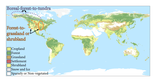
Areas of landcover change in North America
Landcover types from the World Terrestrial Ecosystems (WTE) 2020 dataset (Sayre, 2022).
Landcover types from the World Terrestrial Ecosystems (WTE) 2020 dataset (Sayre, 2022).

Lance Brady (USGS NUSO) and Patricia Bright (USGS) attend meeting at the White House
Lance Brady (USGS NUSO) and Patricia Bright (USGS) attend meeting at the White HouseOn August 27th Lance Brady (USGS NUSO) attended a "White House Roundtable on Emerging Technologies for Preventing Health Emergencies" convened by the White House Office of Science & Technology Policy (OSTP). Patricia Bright, Senior Science Advisor for the USGS Ecosystems Environmental Health Program, was also in attendance.

National Uncrewed Systems Office - Who We Are
Collage of photographs of the researchers in the National Uncrewed Systems Office (NUSO) showing Who We Are
Top Row:
Mark Bauer, Victoria Scholl, Joe Adams, Jill Cress, and Matt Burgess (left)
Todd Burton (middle)
Victoria Scholl (right)
Collage of photographs of the researchers in the National Uncrewed Systems Office (NUSO) showing Who We Are
Top Row:
Mark Bauer, Victoria Scholl, Joe Adams, Jill Cress, and Matt Burgess (left)
Todd Burton (middle)
Victoria Scholl (right)

National Uncrewed Systems Office - What We Do
Collage of photographs taken during various research missions performed by the National Uncrewed Systems Office (NUSO) representing What We Do
Collage of photographs taken during various research missions performed by the National Uncrewed Systems Office (NUSO) representing What We Do
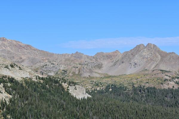
Grizzly Peak Caldera, Southern Rocky Mountain Volcanic Field, Colorado
Grizzly Peak Caldera, Southern Rocky Mountain Volcanic Field, ColoradoThe west side of Lincoln Creek drainage reveals the intricate details of the Grizzly Peak caldera. Dikes cutting the tuff help establish the timing of volcanic activity that shaped this landscape.
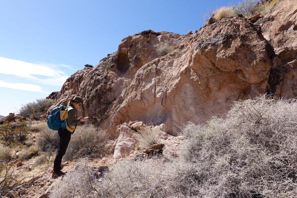
Tectonic and Magmatic evolution of Death Valley, California
Tectonic and Magmatic evolution of Death Valley, CaliforniaGeologist sampling ignimbrites of the Central Death Valley volcanic field for geochronology.
Tectonic and Magmatic evolution of Death Valley, California
Tectonic and Magmatic evolution of Death Valley, CaliforniaGeologist sampling ignimbrites of the Central Death Valley volcanic field for geochronology.

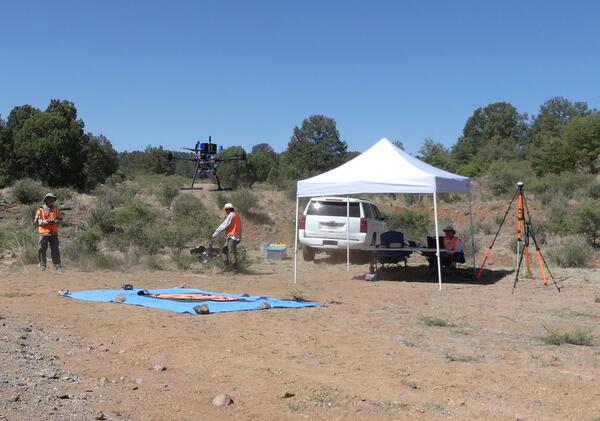
NUSO researchers prepare for evaluation flights with a vertical take-off and landing UAS
NUSO researchers prepare for evaluation flights with a vertical take-off and landing UASNUSO researchers Matt Burgess and Mark Bauer prepare for evaluation flights with the WingtraOne GEN II vertical take-off and landing mapping UAS equipped with the newly released lidar payload.

Field crew standing at the upper overlook on the Marsh-Felch Quarry site.
Field crew standing at the upper overlook on the Marsh-Felch Quarry site.Field crew standing at the upper overlook on the Marsh-Felch Quarry site.
Field crew standing at the upper overlook on the Marsh-Felch Quarry site.
Field crew standing at the upper overlook on the Marsh-Felch Quarry site.Field crew standing at the upper overlook on the Marsh-Felch Quarry site.

USGS personnel standing at the overlook to the quarry prior to conducting UAS operations.
USGS personnel standing at the overlook to the quarry prior to conducting UAS operations.USGS personnel standing at the overlook to the quarry prior to conducting UAS operations.
Thomas Casadevall (Scientist Emeritus with the Geology, Geophysics, and Geochemistry Science Center), Paco Van Sistine (GECSC), Victoria Scholl (NUSO), Matt Burgess (NUSO)

Group photo captured using a drone standing at the overlook for the Marsh-Felch quarry.
Group photo captured using a drone standing at the overlook for the Marsh-Felch quarry.Group photo captured using a drone. Left to right: Matt Burgess (NUSO), Paco Van Sistine (GECSC), Victoria Scholl (NUSO) standing at the overlook for the Marsh-Felch quarry.

Victoria Scholl (NUSO) conducts a UAS flight at the Marsh-Felch Quarry site.
Victoria Scholl (NUSO) conducts a UAS flight at the Marsh-Felch Quarry site.Victoria Scholl (NUSO) conducts a Skydio X10 UAS 3D Scan flight at the
Marsh-Felch Quarry site.
Victoria Scholl (NUSO) conducts a UAS flight at the Marsh-Felch Quarry site.
Victoria Scholl (NUSO) conducts a UAS flight at the Marsh-Felch Quarry site.Victoria Scholl (NUSO) conducts a Skydio X10 UAS 3D Scan flight at the
Marsh-Felch Quarry site.

USGS geologists view the informational sign at the quarry upper overlook in July 2024.
USGS geologists view the informational sign at the quarry upper overlook in July 2024.USGS geologists view the informational sign at the quarry upper overlook in July 2024. The sign describes the history of Professor O.C. Marsh and Marshall P. Felch, the namesakes of the quarry, who worked together to excavate and study dinosaur bones. The sign features a photograph by Israel Cook Russel, a USGS Geologist, in July 1888.
Drone with Gamma Ray Spectrometer
Gamma Ray Spectrometer on drone in New Mexico.
Gamma Ray Spectrometer on drone in New Mexico.
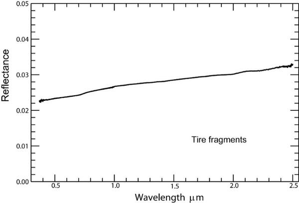
Reflectance spectrum for fragments from a shredded road tire
Reflectance spectrum for fragments from a shredded road tireReflectance spectrum for fragments from a shredded road tire showing a strong capacity to absorb solar radiation. The average reflectance over the spectrum is 0.0280. The reflectance of a flat, pure white surface, such as clean snow, is 1.

High-angle normal fault in the Jackson Mountains, Nevada
High-angle normal fault in the Jackson Mountains, NevadaInvestigating a fault mirror formed on a range-bounding fault that offsets Triassic volcaniclastic rocks of the Jackson Mountains
High-angle normal fault in the Jackson Mountains, Nevada
High-angle normal fault in the Jackson Mountains, NevadaInvestigating a fault mirror formed on a range-bounding fault that offsets Triassic volcaniclastic rocks of the Jackson Mountains

Interactive UAS Science Exhibit on display in Reston
Interactive UAS Science Exhibit on display in RestonInteractive UAS Science Exhibit on display in Reston
Included in this display are some of the earliest UAS platforms operated by the USGS and an interactive touch screen table that provides access to additional information and videos.

Group photo of the field crew at the Lexington boat ramp on the morning of the dye release in the Missouri River.
Group photo of the field crew at the Lexington boat ramp on the morning of the dye release in the Missouri River.Group photo of the field crew at the Lexington boat ramp on the morning of the dye release in the Missouri River.

Tarp secured to an anchored boat to enable radiometric calibration of the UAS hyperspectral data during post-processing.
Tarp secured to an anchored boat to enable radiometric calibration of the UAS hyperspectral data during post-processing.Tarp secured to an anchored boat to enable radiometric calibration of the UAS hyperspectral data during post-processing.

Remote pilots conducting a hyperspectral UAS flight over the Missouri River.
Remote pilots conducting a hyperspectral UAS flight over the Missouri River.Victoria Scholl and Matt Burgess (NUSO) conducting a hyperspectral UAS flight over the Missouri River.
Remote pilots conducting a hyperspectral UAS flight over the Missouri River.
Remote pilots conducting a hyperspectral UAS flight over the Missouri River.Victoria Scholl and Matt Burgess (NUSO) conducting a hyperspectral UAS flight over the Missouri River.