



View looking eastward from the northern Funeral Mountains (California, USA), where early Cenozoic sedimentary strata are unconformably overlain by middle Miocene volcaniclastic deposits.
Images
Images intro.
Filter Total Items: 316
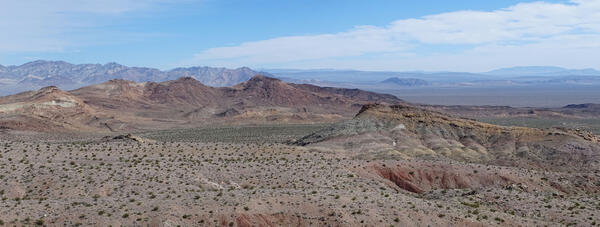
Indian Buttes, California
View looking eastward from the northern Funeral Mountains (California, USA), where early Cenozoic sedimentary strata are unconformably overlain by middle Miocene volcaniclastic deposits.

Tree-ring cross-section
Detail of tree-ring cross-section from southern Colorado. This photo, and others like it, are published in the USGS Data Release "Preserving Tree-Ring Datasets for Climate and Hazard Research and Understanding Societal Impacts: Colorado Fire, Climate, Humans".
Detail of tree-ring cross-section from southern Colorado. This photo, and others like it, are published in the USGS Data Release "Preserving Tree-Ring Datasets for Climate and Hazard Research and Understanding Societal Impacts: Colorado Fire, Climate, Humans".

The YellowScan Navigator Bathymetric Lidar Scanner awaits preflight checks near the South Platte River, Denver, CO.
The YellowScan Navigator Bathymetric Lidar Scanner awaits preflight checks near the South Platte River, Denver, CO.The YellowScan Navigator Bathymetric Lidar Scanner awaits preflight checks near the South Platte River, Denver, CO.
The YellowScan Navigator Bathymetric Lidar Scanner awaits preflight checks near the South Platte River, Denver, CO.
The YellowScan Navigator Bathymetric Lidar Scanner awaits preflight checks near the South Platte River, Denver, CO.The YellowScan Navigator Bathymetric Lidar Scanner awaits preflight checks near the South Platte River, Denver, CO.

Fixed-wing UAS training at Denver Federal Center, January 2024
Fixed-wing UAS training at Denver Federal Center, January 2024In January 2024, Joe Adams of the USGS National Uncrewed Systems Office led an A-454 aviation training course at the Denver Federal Center in Lakewood, Colorado.
Fixed-wing UAS training at Denver Federal Center, January 2024
Fixed-wing UAS training at Denver Federal Center, January 2024In January 2024, Joe Adams of the USGS National Uncrewed Systems Office led an A-454 aviation training course at the Denver Federal Center in Lakewood, Colorado.

Deformed rocks of a Proterozoic shear zone
Geologist Michael Frothingham observes strongly deformed rocks of a Proterozoic shear zone in the Medicine Bow Mountains (Wyoming, USA).
Geologist Michael Frothingham observes strongly deformed rocks of a Proterozoic shear zone in the Medicine Bow Mountains (Wyoming, USA).

Death Valley, California
View to the west across Death Valley (California, USA) to the Panamint Mountains. Alluvial fans (foreground) and the salt lake playa of the Badwater basin (middle ground) occupy the basin floor.
View to the west across Death Valley (California, USA) to the Panamint Mountains. Alluvial fans (foreground) and the salt lake playa of the Badwater basin (middle ground) occupy the basin floor.

Branching bunches of calcite filaments
Photomigrograph (cross-polarized light) showing branching bunches of calcite filaments grown from algal mats in spring-discharge tufas of Cold Creek Spring (Las Vegas region, Nevada, USA).
Photomigrograph (cross-polarized light) showing branching bunches of calcite filaments grown from algal mats in spring-discharge tufas of Cold Creek Spring (Las Vegas region, Nevada, USA).

East Red Mountain in the Grizzly Peak caldera, Colorado
East Red Mountain in the Grizzly Peak caldera, ColoradoVivid red, orange, and yellow colors highlight hydrothermally altered rocks on East Red Mountain in the Grizzly Peak caldera (Sawatch Range, Colorado, USA).
East Red Mountain in the Grizzly Peak caldera, Colorado
East Red Mountain in the Grizzly Peak caldera, ColoradoVivid red, orange, and yellow colors highlight hydrothermally altered rocks on East Red Mountain in the Grizzly Peak caldera (Sawatch Range, Colorado, USA).

Oligocene-Miocene Troublesome outcrop
Intermountain West Project members discuss an outcrop of the Oligocene-Miocene Troublesome Formation (near Kremmling, Colorado, USA).
Intermountain West Project members discuss an outcrop of the Oligocene-Miocene Troublesome Formation (near Kremmling, Colorado, USA).

Sedimentary rocks in Death Valley National Park
Research Geologist Theresa Schwartz walks over Cenozoic sedimentary rocks in Death Valley National Park (California, USA).
Research Geologist Theresa Schwartz walks over Cenozoic sedimentary rocks in Death Valley National Park (California, USA).

Mineral-bearing shoreface deposits in the Upper Cretaceous Trinidad Sandstone
Mineral-bearing shoreface deposits in the Upper Cretaceous Trinidad SandstoneResearch Geologist Marieke Dechesne investigates heavy mineral-bearing shoreface deposits in the Upper Cretaceous Trinidad Sandstone (Raton Basin, New Mexico, USA).
Mineral-bearing shoreface deposits in the Upper Cretaceous Trinidad Sandstone
Mineral-bearing shoreface deposits in the Upper Cretaceous Trinidad SandstoneResearch Geologist Marieke Dechesne investigates heavy mineral-bearing shoreface deposits in the Upper Cretaceous Trinidad Sandstone (Raton Basin, New Mexico, USA).

Joshua trees near Las Vegas
Joshua trees (Yucca brevifolia) grow on middle Cenozoic sedimentary rocks of the Las Vegas region (southern Nevada, USA).
Joshua trees (Yucca brevifolia) grow on middle Cenozoic sedimentary rocks of the Las Vegas region (southern Nevada, USA).

Aeolian deposits of the San Juan River corridor
Intermountain West Project members Adam Hudson and Michael Frothingham inspect young aeolian deposits of the San Juan River corridor (Bluff, Utah, USA).
Intermountain West Project members Adam Hudson and Michael Frothingham inspect young aeolian deposits of the San Juan River corridor (Bluff, Utah, USA).

Cottonwood Pass, Colorado
A view westward from Cottonwood Pass (Sawatch Range, Colorado, USA) into the Taylor Park basin. The peaks in the backgorund are composed of igneous and metamorphic rocks ranging in age from early Paleozoic to Eocene, uplifted along the Taylor Park fault.
A view westward from Cottonwood Pass (Sawatch Range, Colorado, USA) into the Taylor Park basin. The peaks in the backgorund are composed of igneous and metamorphic rocks ranging in age from early Paleozoic to Eocene, uplifted along the Taylor Park fault.

Multi-colored lacustrine shales of the Oligocene Amargosa Valley Formation
Multi-colored lacustrine shales of the Oligocene Amargosa Valley FormationResearch Geologist Jens-Erik Lundstern explores multi-colored lacustrine shales of the Oligocene Amargosa Valley Formation (Bat Mountain, California, USA).
Multi-colored lacustrine shales of the Oligocene Amargosa Valley Formation
Multi-colored lacustrine shales of the Oligocene Amargosa Valley FormationResearch Geologist Jens-Erik Lundstern explores multi-colored lacustrine shales of the Oligocene Amargosa Valley Formation (Bat Mountain, California, USA).
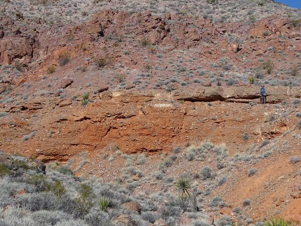
Cenozoic fluvial conglomerates in the Delamar Mountains, Nevada
Cenozoic fluvial conglomerates in the Delamar Mountains, NevadaResearch Geologist Jens-Erik Lundstern poses as a scale for middle Cenozoic fluvial conglomerates in the Delamar Mountains (southern Nevada, USA).
Cenozoic fluvial conglomerates in the Delamar Mountains, Nevada
Cenozoic fluvial conglomerates in the Delamar Mountains, NevadaResearch Geologist Jens-Erik Lundstern poses as a scale for middle Cenozoic fluvial conglomerates in the Delamar Mountains (southern Nevada, USA).

Geologic Framework of the Intermountain West project members
Geologic Framework of the Intermountain West project membersIntermountain West Project members pose at the summit of Crested Butte (Colorado, USA) prior to examining the Crested Butte laccolith (from left to right, Jeremy Workman, Allison Dombrowski, Ian Hillenbrand, Amy Gilmer, Kenzie Turner, and Ren Thompson).
Geologic Framework of the Intermountain West project members
Geologic Framework of the Intermountain West project membersIntermountain West Project members pose at the summit of Crested Butte (Colorado, USA) prior to examining the Crested Butte laccolith (from left to right, Jeremy Workman, Allison Dombrowski, Ian Hillenbrand, Amy Gilmer, Kenzie Turner, and Ren Thompson).

Avery Peak, Colorado
Red sedimentary rocks of the Pennsylvanian-Permian Maroon Formation exposed on Avery Peak dip southwestward away from gray igneous rocks of the Cenozoic White Rock pluton.
Red sedimentary rocks of the Pennsylvanian-Permian Maroon Formation exposed on Avery Peak dip southwestward away from gray igneous rocks of the Cenozoic White Rock pluton.

Pennsylvanian Honaker Trail Formation at Goosenecks State Park
Pennsylvanian Honaker Trail Formation at Goosenecks State ParkIntermountain West Project members Theresa Schwartz and Alexander Lusk investigate the Pennsylvanian Honaker Trail Formation at Goosenecks State Park (Utah, USA).
Pennsylvanian Honaker Trail Formation at Goosenecks State Park
Pennsylvanian Honaker Trail Formation at Goosenecks State ParkIntermountain West Project members Theresa Schwartz and Alexander Lusk investigate the Pennsylvanian Honaker Trail Formation at Goosenecks State Park (Utah, USA).

Moab fault near Arches National Park, Utah
Geologist Alexander Lusk investigates slickenlines on the Moab fault near Arches National Park (Utah, USA).
Geologist Alexander Lusk investigates slickenlines on the Moab fault near Arches National Park (Utah, USA).

Wild burros
Wild burros stand guard on the path to Miocene volcaniclastic rocks of the Death Valley region (California, USA).
Wild burros stand guard on the path to Miocene volcaniclastic rocks of the Death Valley region (California, USA).