



The SQUID-5, or Structure-from-motion (SfM) Quantitative Underwater Imaging Device with 5 cameras, shown being staged for a test run at the St. Petersburg Coastal and Marine Science Center. In the background, Andy Farmer (SPCMSC) and Gerry Hatcher (PCMSC) prep the R/V Sallenger, the vessel being used to tow the device.
Images
St. Petersburg Coastal and Marine Science Center images.
Filter Total Items: 750

SQUID-5 being prepped for a test run
The SQUID-5, or Structure-from-motion (SfM) Quantitative Underwater Imaging Device with 5 cameras, shown being staged for a test run at the St. Petersburg Coastal and Marine Science Center. In the background, Andy Farmer (SPCMSC) and Gerry Hatcher (PCMSC) prep the R/V Sallenger, the vessel being used to tow the device.

R/V Weatherbird II in port
The R/V Weatherbird II docked at the Florida Institute of Oceanography at University of South Florida (USF) College of Marine Science in St. Petersburg, Florida. USGS scientists and partners at Eckerd College and USF load the vessel in preparation for a research cruise as part of a National Science Foundation (NSF)-funded Scientists-at-Sea program.
The R/V Weatherbird II docked at the Florida Institute of Oceanography at University of South Florida (USF) College of Marine Science in St. Petersburg, Florida. USGS scientists and partners at Eckerd College and USF load the vessel in preparation for a research cruise as part of a National Science Foundation (NSF)-funded Scientists-at-Sea program.

Sub-bottom surveying at Seven Mile Island, New Jersey
Sub-bottom surveying at Seven Mile Island, New JerseyA floating sled that enables sub‐bottom surveying in shallow water, nearshore, and shore‐face environments. The sled is equipped with an EdgeTech SB‐512i chirp system and single‐beam sonar. This equipment is used to collect seismic sub‐bottom profiles and single‐beam bathymetry.
Sub-bottom surveying at Seven Mile Island, New Jersey
Sub-bottom surveying at Seven Mile Island, New JerseyA floating sled that enables sub‐bottom surveying in shallow water, nearshore, and shore‐face environments. The sled is equipped with an EdgeTech SB‐512i chirp system and single‐beam sonar. This equipment is used to collect seismic sub‐bottom profiles and single‐beam bathymetry.

Trayectorias de los huracanes, Puerto Rico
Trayectorias de los huracanes Hugo (1989), Georges (1998), Irma (2017) y María (2017). Datos provistos por la NOAA. La imagen de base es propiedad intelectual de Esri y se usa aquí bajo licencia. Los derechos de autor y reproducción son propiedad de Esri y sus licenciatarios.
Trayectorias de los huracanes Hugo (1989), Georges (1998), Irma (2017) y María (2017). Datos provistos por la NOAA. La imagen de base es propiedad intelectual de Esri y se usa aquí bajo licencia. Los derechos de autor y reproducción son propiedad de Esri y sus licenciatarios.
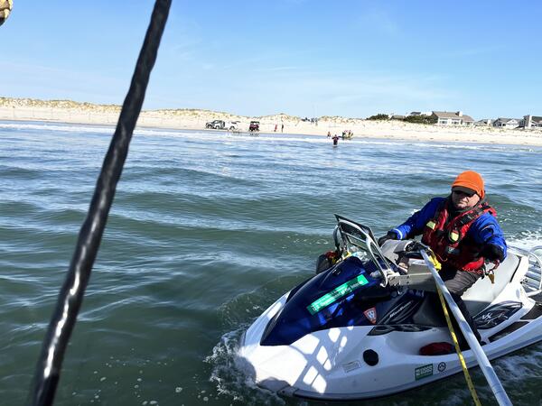
Multiple gears used to collect data on the Seven Mile Island shoreface
Multiple gears used to collect data on the Seven Mile Island shorefaceBJ Reynolds of the St. Petersburg Coastal and Marine Science Center operates a personal watercraft near the shoreline of Seven Mile Island, New Jersey. This vessel is used to collect single beam bathymetry (depth and seafloor shape) in the nearshore, and the equipment on the shoreline is used to collect chirp seismic reflection on the shoreface and inner shelf.
Multiple gears used to collect data on the Seven Mile Island shoreface
Multiple gears used to collect data on the Seven Mile Island shorefaceBJ Reynolds of the St. Petersburg Coastal and Marine Science Center operates a personal watercraft near the shoreline of Seven Mile Island, New Jersey. This vessel is used to collect single beam bathymetry (depth and seafloor shape) in the nearshore, and the equipment on the shoreline is used to collect chirp seismic reflection on the shoreface and inner shelf.

Coasts, Estuaries, Wetlands, and Marshes
Photograph collage representing different coastlines; permafrost coasts, sandy beaches, rocky beaches, wetlands and marshes, cliff-backed beaches, and estuaries.
Photograph collage representing different coastlines; permafrost coasts, sandy beaches, rocky beaches, wetlands and marshes, cliff-backed beaches, and estuaries.

Bathymetric digital elevation model (DEM) of Eastern Dry Rocks coral reef, Florida, 2021
Bathymetric digital elevation model (DEM) of Eastern Dry Rocks coral reef, Florida, 2021A digital elevation model (DEM) was created from underwater images collected at Eastern Dry Rocks coral reef near Key West, Florida, in May 2021 using the SQUID-5 camera system. The underwater images were processed using Structure-from-Motion (SfM) photogrammetry techniques into a classified two-class ('unclassified' and 'low noise') 3D point cloud.
Bathymetric digital elevation model (DEM) of Eastern Dry Rocks coral reef, Florida, 2021
Bathymetric digital elevation model (DEM) of Eastern Dry Rocks coral reef, Florida, 2021A digital elevation model (DEM) was created from underwater images collected at Eastern Dry Rocks coral reef near Key West, Florida, in May 2021 using the SQUID-5 camera system. The underwater images were processed using Structure-from-Motion (SfM) photogrammetry techniques into a classified two-class ('unclassified' and 'low noise') 3D point cloud.

Research Geologist Daniel Ciarletta holds up a sand auger core collected at Fire Island
Research Geologist Daniel Ciarletta holds up a sand auger core collected at Fire IslandScientists collected sand auger cores from Fire Island to help reconstruct the evolution of the barrier over the last several centuries, with the goal of quantifying changes in sediment input and partitioning through time (e.g., how sand is distributed between the terrestrial portion of the barrier and the beach/shoreface).
Research Geologist Daniel Ciarletta holds up a sand auger core collected at Fire Island
Research Geologist Daniel Ciarletta holds up a sand auger core collected at Fire IslandScientists collected sand auger cores from Fire Island to help reconstruct the evolution of the barrier over the last several centuries, with the goal of quantifying changes in sediment input and partitioning through time (e.g., how sand is distributed between the terrestrial portion of the barrier and the beach/shoreface).

Looking towards the beach in the High Dune Wilderness of Fire Island
Looking towards the beach in the High Dune Wilderness of Fire IslandLooking over the dunes towards the beach in the Otis Pike Fire Island High Dune Wilderness at Fire Island, New York.
Looking towards the beach in the High Dune Wilderness of Fire Island
Looking towards the beach in the High Dune Wilderness of Fire IslandLooking over the dunes towards the beach in the Otis Pike Fire Island High Dune Wilderness at Fire Island, New York.

Geologist Julie Bernier examines a water-logged sand auger core
Geologist Julie Bernier examines a water-logged sand auger coreScientists collected sand auger cores from Fire Island to help reconstruct the evolution of the barrier over the last several centuries, with the goal of quantifying changes in sediment input and partitioning through time (e.g. how sand is distributed between the terrestrial portion of the barrier and the beach/shoreface).
Geologist Julie Bernier examines a water-logged sand auger core
Geologist Julie Bernier examines a water-logged sand auger coreScientists collected sand auger cores from Fire Island to help reconstruct the evolution of the barrier over the last several centuries, with the goal of quantifying changes in sediment input and partitioning through time (e.g. how sand is distributed between the terrestrial portion of the barrier and the beach/shoreface).

SCUBA diving over a coral reef
Student contractor Erin Lyons swims over a coral reef during research surveys.
Student contractor Erin Lyons swims over a coral reef during research surveys.
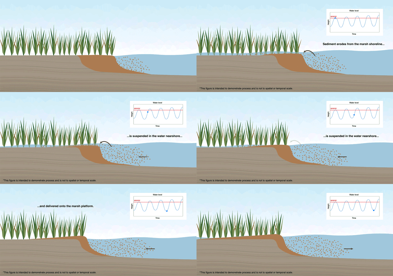
Marsh lateral shoreline erosion and shore-proximal sediment deposition
Marsh lateral shoreline erosion and shore-proximal sediment depositionSalt marshes provide important economic and ecologic services but are vulnerable to habitat loss, particularly due to shoreline erosion from storms and sea level rise. Sediments eroded at the marsh edge are either delivered onto the marsh platform or into the estuary, the latter resulting in a net loss to the marsh sediment budget and released soil carbon.
Marsh lateral shoreline erosion and shore-proximal sediment deposition
Marsh lateral shoreline erosion and shore-proximal sediment depositionSalt marshes provide important economic and ecologic services but are vulnerable to habitat loss, particularly due to shoreline erosion from storms and sea level rise. Sediments eroded at the marsh edge are either delivered onto the marsh platform or into the estuary, the latter resulting in a net loss to the marsh sediment budget and released soil carbon.

Mapped shoreline position from 1848 to 2014 overlaid on 2020 U.S. Department of Agriculture (USDA) National Aerial Imagery Program (NAIP) natural-color aerial imagery provide evidence of coastal wetland change over time
Mapped shoreline position from 1848 to 2014 overlaid on 2020 U.S. Department of Agriculture (USDA) National Aerial Imagery Program (NAIP) natural-color aerial imagery provide evidence of coastal wetland change over timeCoastal wetland shoreline position is mapped from historic and modern data sources, such as topographic sheets, aerial imagery, and satellite imagery. From these data, the shoreline change rate is determined from the date of the data source and the distance between each shoreline.
Mapped shoreline position from 1848 to 2014 overlaid on 2020 U.S. Department of Agriculture (USDA) National Aerial Imagery Program (NAIP) natural-color aerial imagery provide evidence of coastal wetland change over time
Mapped shoreline position from 1848 to 2014 overlaid on 2020 U.S. Department of Agriculture (USDA) National Aerial Imagery Program (NAIP) natural-color aerial imagery provide evidence of coastal wetland change over timeMapped shoreline position from 1848 to 2014 overlaid on 2020 U.S. Department of Agriculture (USDA) National Aerial Imagery Program (NAIP) natural-color aerial imagery provide evidence of coastal wetland change over time
Mapped shoreline position from 1848 to 2014 overlaid on 2020 U.S. Department of Agriculture (USDA) National Aerial Imagery Program (NAIP) natural-color aerial imagery provide evidence of coastal wetland change over timeCoastal wetland shoreline position is mapped from historic and modern data sources, such as topographic sheets, aerial imagery, and satellite imagery. From these data, the shoreline change rate is determined from the date of the data source and the distance between each shoreline.

Survey of camera calibration target
USGS scientists survey the precise location of a camera calibration target. The surveyed locations are used to georeference USGS CoastCam imagery.
USGS scientists survey the precise location of a camera calibration target. The surveyed locations are used to georeference USGS CoastCam imagery.

Alisha Ellis in the marsh
Geologist Alisha Ellis kneels in the marsh grass while collecting sediment samples in Mississippi.
Geologist Alisha Ellis kneels in the marsh grass while collecting sediment samples in Mississippi.

Isotopic Water Analyzer
This Picarro L2130-i Isotope and Gas Concentration Analyzer is housed at the USGS St. Petersburg Coastal and Marine Science Center.
This Picarro L2130-i Isotope and Gas Concentration Analyzer is housed at the USGS St. Petersburg Coastal and Marine Science Center.

Dune Restoration in Isabela, Puerto Rico
Dune restoration efforts in Isabela, Puerto Rico, using wooden planks to promote sand accumulation.
Dune restoration efforts in Isabela, Puerto Rico, using wooden planks to promote sand accumulation.

Wooden boardwalk built to protect fragile dunes from pedestrians in Isabela, Puerto Rico.
Wooden boardwalk built to protect fragile dunes from pedestrians in Isabela, Puerto Rico.Wooden boardwalk built to protect fragile dunes from pedestrians in Isabela, Puerto Rico.
Wooden boardwalk built to protect fragile dunes from pedestrians in Isabela, Puerto Rico.
Wooden boardwalk built to protect fragile dunes from pedestrians in Isabela, Puerto Rico.Wooden boardwalk built to protect fragile dunes from pedestrians in Isabela, Puerto Rico.

Mangroves grow along the coast in La Parguera, Lajas, Puerto Rico
Mangroves grow along the coast in La Parguera, Lajas, Puerto RicoMangroves grow along the coast in La Parguera, Lajas, Puerto Rico. Mangroves help protect the coast during storms.
Mangroves grow along the coast in La Parguera, Lajas, Puerto Rico
Mangroves grow along the coast in La Parguera, Lajas, Puerto RicoMangroves grow along the coast in La Parguera, Lajas, Puerto Rico. Mangroves help protect the coast during storms.

Coral reef in La Parguera, Lajas, Puerto Rico, View 1
Coral reef in La Parguera, Lajas, Puerto Rico, View 1Coral reef in La Parguera, Lajas Puerto Rico shows various types and conditions of corals, including sea fan corals (Gorgonia) in the center.
Coral reef in La Parguera, Lajas, Puerto Rico, View 1
Coral reef in La Parguera, Lajas, Puerto Rico, View 1Coral reef in La Parguera, Lajas Puerto Rico shows various types and conditions of corals, including sea fan corals (Gorgonia) in the center.

Coral reef in La Parguera, Lajas, Puerto Rico, View 2
Coral reef in La Parguera, Lajas, Puerto Rico, View 2Coral reef in La Parguera, Lajas Puerto Rico shows a sea fan coral (Gorgonia) in the center, surrounded other corals and fishes.
Coral reef in La Parguera, Lajas, Puerto Rico, View 2
Coral reef in La Parguera, Lajas, Puerto Rico, View 2Coral reef in La Parguera, Lajas Puerto Rico shows a sea fan coral (Gorgonia) in the center, surrounded other corals and fishes.