



Coastal Change Likelihood Assessment--Predicting Coastal Landscape Change with Accuracy
Woods Hole Coastal and Marine Science Center Newsletter: August-November 2025
Sharing science stories, popular social media posts, recent publications, fieldwork activities, and more center happenings.
Sharing science stories, popular social media posts, recent publications, fieldwork activities, and more center happenings.
Sound Waves Newsletter
Explore coastal and marine science from across the USGS in Sound Waves.
Explore coastal and marine science from across the USGS in Sound Waves.
Natural Disaster Preparedness Starts with Science
The USGS Coastal and Marine Hazards and Resources Program provides information needed to protect coastal communities
The USGS Coastal and Marine Hazards and Resources Program provides information needed to protect coastal communities
Helping Our Neighbors: USGS Surveys Primary Drinking Water Source for the Town of Falmouth
USGS Seafloor Mapping Provides the Scientific Foundation Needed to Address National Priorities
We Make Treasure Maps: USGS Charts the Seafloor to Help Locate Critical Minerals, Precious Metals, and Other Vital Resources
Valuable Data Collected on M7.0 Earthquake Offshore Cape Mendocino, California
Successful deployment and retrieval of Rapid Response Ocean Bottom Seismographs represents significant advancement in natural hazards research
Successful deployment and retrieval of Rapid Response Ocean Bottom Seismographs represents significant advancement in natural hazards research
Approaching Storms
Discover USGS tools that forecast storms and report coastal conditions for emergency management
Discover USGS tools that forecast storms and report coastal conditions for emergency management
Woods Hole Coastal and Marine Science Center
Our center is one of three facilities serving the mission of the USGS Coastal and Marine Hazards and Resources Program.
We study extreme events and physical, biological, and chemical processes that shape our coastal and marine environments. Using this information, we identify hazards and provide critical information on our Nation’s resources. Our research and science-based products provide the strong scientific foundation needed by decisions makers, scientists, and state and federal agencies to address public safety, national security, and resource management across our Nation’s coastal and submerged lands.
Research
Research

Read about our science projects, find out where we are working and why it matters

Highlights
Highlights
- Sound Waves: Coastal and Marine Research News from Across the USGS
- Woods Hole Coastal and Marine Science Center Newsletter
- Annual Reports and General Information Product
- Woods Hole Coastal and Marine Science Center Field Activities
- Employment Opportunities
- Featured USGS Series Report
- Decadal Science Strategy
News
Woods Hole Coastal and Marine Science Center Newsletter: Spring 2026
Woods Hole Coastal and Marine Science Center Newsletter: Spring 2026
A Path to National-Scale Coastal Change Projections
A Path to National-Scale Coastal Change Projections
Your Favorite Software for Calculating Shoreline Change Just Got Better
Your Favorite Software for Calculating Shoreline Change Just Got Better
Publications
Storm surge barriers reduce seaward sediment supply to lagoonal estuaries Storm surge barriers reduce seaward sediment supply to lagoonal estuaries
Numerical simulations with realistic forcing of fixed infrastructure for a proposed storm surge barrier for a lagoonal estuary, Jamaica Bay (New York, USA), are analyzed during typical forcing conditions to assess alterations to flow and sediment transport with the barrier open. Lagoonal estuaries are shallow and have modest watershed freshwater and sediment inputs, so sediment delivery...
Acoustic measurements and modeling of sub-bottom layers on the summit of the Atlantis II Seamount Acoustic measurements and modeling of sub-bottom layers on the summit of the Atlantis II Seamount
Sub-bottom profiler images taken from the summit plateau of the Atlantis II Seamount reveal distinct seabed stratigraphy, including marine sediment, limestone, and basalt layers. Acoustic reflection data also show arrivals reflecting from this sub-bottom structure. A wavenumber integration model with elastic geoacoustic properties is able to reproduce the arrival pattern of seabed...
Spatial heterogeneity of salt marsh vulnerability to sea-level rise: Dual controls of hydrological setting and salinity regime Spatial heterogeneity of salt marsh vulnerability to sea-level rise: Dual controls of hydrological setting and salinity regime
Salt marsh vulnerability to sea-level rise (SLR) is typically assessed using point measurements of vertical accretion, neglecting three-dimensionality of geomorphic evolution and spatial variability. Recent studies suggest links between vertical and horizontal vulnerability, with differences between oligohaline and polyhaline marshes, yet these relationships remain untested in estuary...
Science
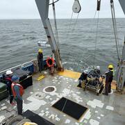
Coastal and Marine Science in Long Island Sound
Long Island Sound is a highly productive estuary and vital natural resource bordering New York and Connecticut. It’s essential for its massive economic impact, generating billions annually by supporting recreation, fisheries, and transportation, as well as its biodiversity, serving as a critical habitat for thousands of marine species. USGS research in Long Island Sound helps protect these...
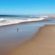
National Shoreline Change Data Publication Catalog
The U.S. Geological Survey (USGS) maintains shoreline positions for the United States from older sources, such as aerial photos and topographic surveys, and contemporary sources like digital elevation models (DEMs) and lidar elevation point cloud data. It's important to maintain, and make available, records of historical shoreline positions to allow monitoring of change over time, and to identify...
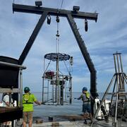
Offshore Analysis of Seafloor Instability and Sediments (OASIS)
The Offshore Analysis of Seafloor Instability and Sediments (OASIS) project is an interagency partnership coordinated by the Bureau of Ocean Energy Management to better understand underwater mudslides and their impacts in the Mississippi River Delta Front. The USGS plays a central role in the project, contributing long-term expertise in coastal and marine geology, seafloor mapping, and geohazard...