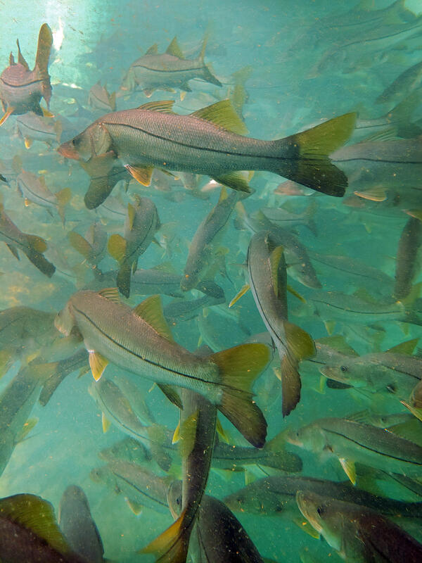
U.S. flag

An official website of the United States government

Images

Images

Filter Total Items: 9443
GIF showing bubbling lava in a lake
Lava Bubbling Inside of a Lava Lake

An animated GIF showing bubbling lava from inside the lava lake at Kīlauea Volcano, Hawaii on Jan 6, 2021.

An animated GIF showing bubbling lava from inside the lava lake at Kīlauea Volcano, Hawaii on Jan 6, 2021.

Image shows an aerial view of rolling hills and rock formations
Western North Slope Foothills

The Kukpowruk River cuts through folded Cretaceous rocks in the central North Slope. These rocks were assessed by the USGS in 2017 and lie above the rocks assessed in the USGS 2021 Western North Slope assessment.

The Kukpowruk River cuts through folded Cretaceous rocks in the central North Slope. These rocks were assessed by the USGS in 2017 and lie above the rocks assessed in the USGS 2021 Western North Slope assessment.

Image shows grass-covered rocks with rolling hills in the background
Tingmerkpuk Ridges
Tingmerkpuk Ridges
Tingmerkpuk Ridges

Jurassic rocks exposed in thurst-faulted structures near the southern limit of Western North Slope. In the subsurface farther north, these rocks may be reservoir rocks for natural gas.

Jurassic rocks exposed in thurst-faulted structures near the southern limit of Western North Slope. In the subsurface farther north, these rocks may be reservoir rocks for natural gas.

Image shows rocky ground with grasslands and a USGS scientist in the background
Western North Slope Foothills

Geologist hikes across folded Cretaceous rocks in the central North Slope. These rocks were assessed by the USGS in 2017 and lie above the rocks assessed in the USGS 2021 Western North Slope assessment.

Geologist hikes across folded Cretaceous rocks in the central North Slope. These rocks were assessed by the USGS in 2017 and lie above the rocks assessed in the USGS 2021 Western North Slope assessment.

A map with elevation showing an indefinite surface connector.
Elevation-Derived Hydrography READ Rules: Indefinite Surface Connector

Example of indefinite surface connector features providing network connectivity through an area without clear channelization.

a tower in the middle of a bright orange sky with trees in the foreground
forest tower at the Alaska Peatland Experiment

A forest tower after a storm at the Alaska Peatland Experiment, a permafrost thaw research site. The tower helps researchers understand the ecosystem’s carbon balance.

A forest tower after a storm at the Alaska Peatland Experiment, a permafrost thaw research site. The tower helps researchers understand the ecosystem’s carbon balance.

Camille Hopkins holds a military working dog.
Camille Hopkins with a military working dog in Iraq

Camille Hopkins, the Wildlife Disease Coordinator for the USGS Ecosystems Mission Area, with a military working dog in Iraq. Camille served in the United States Army as a Veterinary Corps officer, where she had the opportunity to care for military working dogs in the U.S. and overseas.

Camille Hopkins, the Wildlife Disease Coordinator for the USGS Ecosystems Mission Area, with a military working dog in Iraq. Camille served in the United States Army as a Veterinary Corps officer, where she had the opportunity to care for military working dogs in the U.S. and overseas.

A short animation showing lava spewing from a fissure and a rotating tower of smoke.
Lava Spewing from Fissure; Lavanado — Kīlauea

This animated GIF is captured from a USGS video which shows both lava erupting from a fissure and a wind vortex (lavanado) over the lava lake at Kīlauea Volcano.

This animated GIF is captured from a USGS video which shows both lava erupting from a fissure and a wind vortex (lavanado) over the lava lake at Kīlauea Volcano.

Lava bubbling out of a fissure at night time.
Lava Erupting from a Fissure

Animated GIF of lava erupting from a fissure at Kīlauea Volcano at night time on December 27, 2020. 

Animated GIF of lava erupting from a fissure at Kīlauea Volcano at night time on December 27, 2020. 

Lava bubbling out of a fissure at night time.
Lava Erupting from a Fissure

Animated GIF of lava erupting from a fissure at Kīlauea Volcano at night time on December 27, 2020. 

Animated GIF of lava erupting from a fissure at Kīlauea Volcano at night time on December 27, 2020. 

Animation showing bright orange lava erupting at night and flowing into a pool of lava.
Lava Erupting at Kīlauea (Dec 2020)

This animation shows lava erupting from Kīlauea Volcano on Dec 20, 2020. 

Click image for full description and details.
Department of the Interior Bison Conservation Initiative 2020

Bison
Since the late 19th century, the Department of the Interior, in collaboration with others, has been a leader in shared conservation stewardship of bison and manages...

Bison
Since the late 19th century, the Department of the Interior, in collaboration with others, has been a leader in shared conservation stewardship of bison and manages...

Airplane and helicopter
Cessna Grand Caravan fixed-wing and an Airbus A350 B3 helicopter

Survey aircraft include a Cessna Grand Caravan fixed-wing and an Airbus A350 B3 helicopter with magnetometer stinger and towed bird respectively. Photos courtesy of Dewberry Engineers, Inc.

Survey aircraft include a Cessna Grand Caravan fixed-wing and an Airbus A350 B3 helicopter with magnetometer stinger and towed bird respectively. Photos courtesy of Dewberry Engineers, Inc.

Map
Flight area for Trans-Pecos aeromagnetic and radiometric survey

Map indicating flight area for Trans-Pecos aeromagnetic and radiometric survey. The survey area includes parts of El Paso and Hudspeth counties, Texas, and Otero County, New Mexico. Flights will begin in November 2020 and are expected to conclude in mid-January 2021. 

Map indicating flight area for Trans-Pecos aeromagnetic and radiometric survey. The survey area includes parts of El Paso and Hudspeth counties, Texas, and Otero County, New Mexico. Flights will begin in November 2020 and are expected to conclude in mid-January 2021. 

Image shows three men in safety equipment standing next to a drill rig
USGS Technicians Prepare to Take a Core of the Austin Chalk in Texas

USGS technicians at the USGS Gulf Coast #4 Bonham borehole in preparation for geophysical logging of the Austin Chalk Group and the Eagle Ford Group mudstones, Fannin County, Texas.

Image shows a rock core in a trough
Austin Chalk Core
Austin Chalk Core
Austin Chalk Core

Bedding features in the core from the USGS Gulf Coast #4 Bonham borehole, in the Eagle Ford Group mudstones from a depth of about 401 feet, Fannin County, Texas. The Eagle Ford Group lies underneath the Austin Chalk and serves as the source rock for much of the Austin Chalk's petroleum.

Bedding features in the core from the USGS Gulf Coast #4 Bonham borehole, in the Eagle Ford Group mudstones from a depth of about 401 feet, Fannin County, Texas. The Eagle Ford Group lies underneath the Austin Chalk and serves as the source rock for much of the Austin Chalk's petroleum.

Image shows two pyramidal rock outcroppings with grass coverings
Kukpowruk Redwul
Kukpowruk Redwul
Kukpowruk Redwul

Geologist examines f Faulted and folded petroleum source rocks in Jurassic and Cretaceous rocks (Kingak Shale, pebble shale unit, and gamma-ray zone of Hue Shale) in southern part of Western North Slope. Thermal maturity of these rocks is at the upper limit of oil preservations.

Geologist examines f Faulted and folded petroleum source rocks in Jurassic and Cretaceous rocks (Kingak Shale, pebble shale unit, and gamma-ray zone of Hue Shale) in southern part of Western North Slope. Thermal maturity of these rocks is at the upper limit of oil preservations.

Was this page helpful?