
Thirty-eight new surface water gages established
June 2024 - Sept 2025
June 2024 - Sept 2025
Dust from the Great Salt Lake dry lakebed: a possible health risk for communities in northern Utah
New HIVIS Camera Installed
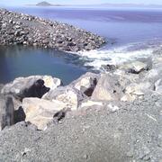
North Fork Virgin River in Zion National Park (09405500)
North Fork Virgin River in Zion National Park (09405500)
Great Salt Lake Hydro Mapper
Great Salt Lake Elevations
USGS Science Collaboration Portal for the Colorado River Basin
Groundwater in Utah
Bear Lake Water Quality
Utah Water Science Center
Welcome to the USGS Utah Water Science Center webpage. We collaborate with many partners to monitor, assess, conduct targeted research, and deliver information on a wide range of water resources. Explore some of our work through these pages.
Water Dashboard
Water Dashboard

Use the National Water Dashboard to access real-time stream, lake, reservoir, and groundwater information.
Groundwater App
Groundwater App

Use the National Groundwater App to view actively monitored well locations. See water levels at a glance and access hydrographs easily.
Quick Links
Quick Links
News
Geospatial Applications to Visualize Science and Support Decision‑Making Across Scales
Geospatial Applications to Visualize Science and Support Decision‑Making Across Scales
2025 in Review: The Saline Lake Ecosystems Integrated Water Availability Assessment
2025 in Review: The Saline Lake Ecosystems Integrated Water Availability Assessment
Saline Lake Ecosystems IWAA February 2025 Seminar
Saline Lake Ecosystems IWAA February 2025 Seminar
Publications
Contributions of Great Salt Lake playa- and industrially-sourced priority pollutant metals in dust contribute to possible health hazards in the communities of northern Utah Contributions of Great Salt Lake playa- and industrially-sourced priority pollutant metals in dust contribute to possible health hazards in the communities of northern Utah
Communities and ecosystems of northern Utah, USA receive particulate pollution from anthropogenic activity and dust emissions from sources including the Great Salt Lake (“the Lake”) playa. In addition to affecting communities, anthropogenic pollution is delivered to the Lake's playa sediments, which are eroded during dust events. Yet, spatial variability in dust flux and composition and...
Application of mercury stable isotopes to examine sources and hydrologic factors impacting mercury bioaccumulation and cycling in invertebrates of a model saline lake Application of mercury stable isotopes to examine sources and hydrologic factors impacting mercury bioaccumulation and cycling in invertebrates of a model saline lake
Invertebrates, such as brine shrimp and brine flies, are key prey items for millions of resident and migratory birds that utilize saline lakes such as Great Salt Lake (GSL). Elevated methylmercury (MeHg) in invertebrate and waterfowl species of GSL has been assumed to be linked to elevated MeHg in GSL’s anoxic Deep Brine Layer (DBL) where aqueous concentrations can exceed 30 ng/L. Here...
Estimation of baseflow and flooding characteristics for East Canyon Creek, Summit and Morgan Counties, Utah Estimation of baseflow and flooding characteristics for East Canyon Creek, Summit and Morgan Counties, Utah
An improved understanding of hydrologic responses to changing climatic conditions is needed to better inform water management practices. East Canyon Creek, a perennial, snowmelt-dominated stream in the Wasatch Mountains of northern Utah, is subjected to increasing development and demands on water in the Snyderville Basin and adjacent areas. In this study, streamflow and specific...
Science
Dust from the Great Salt Lake dry lakebed: a possible health risk for communities in northern Utah
By analyzing dust samples in northern Utah, the USGS is providing crucial insights about the importance of water and lakebed management to mitigate dust pollution and protect vulnerable communities in northern Utah.

Navigating PFAS Contamination: Insights from the USGS Potomac River Watershed Study
The Potomac River is a major watershed in the eastern United States that serves as a crucial water supply for millions of people. USGS researchers conducted a comprehensive investigation to identify the contributions of municipal and industrial wastewater treatment plant effluent to the levels of per-and polyfluoroalkyl substances (PFAS) in the Potomac River. This study included measuring PFAS...

Leading the Way: Specialized Laboratory Contributions to Environmental Health
The Environmental Health Program features a Unified Core Technology Team comprised of multiple laboratories with specialized expertise that support the overall program research assessing actual and perceived risks from environmental contaminants and pathogens. Individual Core Technology Teams work closely with the Integrated Science Teams to ensure current and emerging techniques are being used to...
By
Ecosystems Mission Area, Contaminant Biology, Environmental Health Program, Toxic Substances Hydrology, California Water Science Center, Columbia Environmental Research Center, Eastern Ecological Science Center, Maryland-Delaware-D.C. Water Science Center, New England Water Science Center, New Jersey Water Science Center, Upper Midwest Water Science Center, Utah Water Science Center, Wetland and Aquatic Research Center