A cross-sectional view of a hypothetical coastline showing one possible arrangement of the three Federal Flood Risk Management Standard (FFRMS) floodplain elevations (Climate-Informed Science Approach, the Freeboard Value Approach, and the 0.2% Annual-Chance Flood Approach) above the current Base Flood Elevation, i.e., the 1% annual-chance flood elevation.
Faith A Fitzpatrick
Faith Fitzpatrick is a research hydrologist at the Upper Midwest Water Science Center.
She has spent much of her career studying geomorphic characteristics and sediment dynamics of rivers related to land use and climate change. Her area of expertise is in historical watershed geomorphology and sediment budgets, specifically identifying natural and human causes for accelerated erosion and sedimentation problems, flooding, habitat degradation, eutrophication, and sources of contaminants. She works closely with water resources and fisheries managers from a variety of agencies in a scientific support role for decision-making. She recently completed an assignment as scientific support coordinator for EPA for the pipeline release of diluted bitumen into the Kalamazoo River Michigan. She is a lecturer in the UW-Madison Geography Department and an instructor for the USGS Training Center.
Education and Certifications
Ph.D. Physical Geography (Fluvial Geomorphology), Minor in Civil Engineering, University of Wisconsin-Madison, Wisconsin. Dissertation: "Geomorphic and hydrologic responses to vegetation, climate, and
M.S. in Geology, University of Illinois, Illinois. Thesis: "Fluvial geomorphology of two contrasting tributaries of the Vermilion River, east-central Illinois", 1985-1988
B.S. in Geology, Minor in Chemistry, Lake Superior State University, Sault Ste. Marie, Michigan, 1981-1985
Science and Products
Assessing River Erosion and Sedimentation in Ecuador
MMSD Watercourse Corridor Study: Nutrient Evaluations
MMSD Watercourse Corridor Study: Geomorphology and Sediment Studies Related to Stream and Estuary Rehabilitation
Kalamazoo River AOC Dam Removal Geomorphic/Habitat Assessments – Reference Reach Identification
Hydrogeomorphic Classification and Conceptual Model
Environmental Effects of Agricultural Practices
Fluvial geomorphology studies
Measuring Suspended-Sediment Concentrations, Grain Sizes and Bedload using Acoustic Doppler Velocity Meters and Echologgers in the Lower Chippewa River, Wisconsin
Upper Pecatonica River Wisconsin Buffer Initiative pilot project
Rapid Deployment Gages (RDGs)
USGS Flood Information
Surge, Wave, and Tide Hydrodynamics (SWaTH) Network
Water level, inundation, longitudinal profile, geomorphic change, and landform data for the Bad River (Mashkiiziibii) Estuary, WI, between 2014 and 2023
Update DOI example
Kinnickinnic River Geochemistry and Rapid Geomorphic Assessments, Waukesha County, Wisconsin
Geomorphic Habitat Response Units Attributes for the Wisconsin DNR 24k Hydrography Flowline Network in the Milwaukee River Basin, Wisconsin
Geomorphic Reference Reach Data for the Kalamazoo River Basin, Michigan Area of Concern
Topobathymetric Digital Elevation Model (TBDEM) of the Milwaukee River Estuary, MIlwaukee, WI and adjacent terrestrial and Lake Michigan nearshore coastal areas
Fluvial Erosion Hazard Rapid Geomorphic Assessment Data from the Marengo Watershed, Ashland County, Wisconsin
Suspended-sediment, bedload, bed-sediment, and multibeam sonar data in the Chippewa River, WI
Code associated with analysis and modeling of benthic and pelagic inorganic nutrient processing rates at the interface between a river and lake
Black Creek Rapid Geomorphic Assessment, Allen County, Indiana
Historic Lake Superior shorelines near Odanah, Wisconsin (1852 - 2013)
Selected sediment data and results from regression models, modified Einstein Prodecure, and loads estimation for the Nemadji River, 1973-2016
A cross-sectional view of a hypothetical coastline showing one possible arrangement of the three Federal Flood Risk Management Standard (FFRMS) floodplain elevations (Climate-Informed Science Approach, the Freeboard Value Approach, and the 0.2% Annual-Chance Flood Approach) above the current Base Flood Elevation, i.e., the 1% annual-chance flood elevation.
A cross-sectional view of a hypothetical river showing one possible arrangement of the three Federal Flood Risk Management Standard (FFRMS) floodplain elevations (Climate-Informed Science Approach, the Freeboard Value Approach, and the 0.2% Annual-Chance Flood Approach) above the current Base Flood Elevation, i.e., the 1% annual-chance flood elevation.
A cross-sectional view of a hypothetical coastline showing one possible arrangement of the three Federal Flood Risk Management Standard (FFRMS) floodplain elevations (Climate-Informed Science Approach, the Freeboard Value Approach, and the 0.2% Annual-Chance Flood Approach) above the current Base Flood Elevation, i.e., the 1% annual-chance flood elevation.
Faith Fitzpatrick taking her Bernese Mountain dog on a hike to check out rock outcrops around southern Wisconsin.
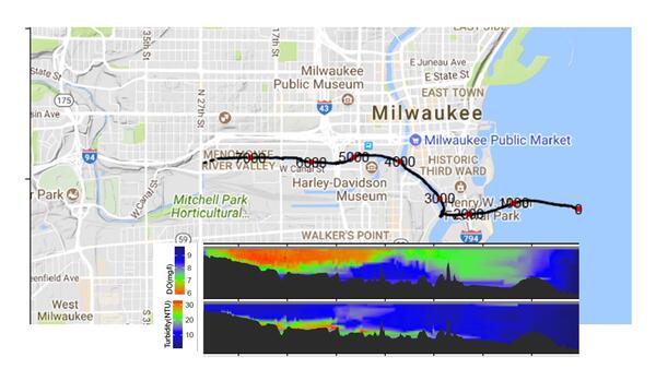
Map of dissolved oxygen and turbidity along the Milwaukee River.
These data are preliminary or provisional and are subject to revision. They are being provided to meet the need for timely best science.
Map of dissolved oxygen and turbidity along the Milwaukee River.
These data are preliminary or provisional and are subject to revision. They are being provided to meet the need for timely best science.
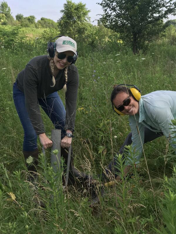
In this photo, USGS scientists Megan Haserodt (Hydrologist) and Jenelle Wempner (Student Intern) install a double ring infiltrometer along a recreated floodplain of Underwood Creek, a tributary to the Milwaukee River and Lake Michigan in Milwaukee, Wisconsin.
Bank erosion along an upstream reach of the Kinnickinnic River, October 2018.
An example stream reach of Underwood Creek’s channel in 2018 after rehabilitation.
Milwaukee River Estuary, March 2016
Confluence of inner harbor and the Milwaukee River along North Riverwalk Way, leading into downtown Milwaukee, Wisconsin in early spring.
Influences of meteorological conditions, runoff, and bathymetry on summer thermal regime of a Great Lakes estuary
Sediment budget of a Maumee River headwater tributary: How streambank erosion, streambed-sediment storage, and streambed-sediment source inform our understanding of legacy phosphorus
Connecting flood-related fluvial erosion and deposition with vulnerable downstream road-stream crossings
Stream corridor sediment budget for watershed sediment source apportionment for the forested Little Fork River, Minnesota
Stream corridor sources of suspended sediment and sediment-bound phosphorus from an urban tributary to the Great Lakes
A conceptual workflow for projecting future riverine and coastal flood hazards to support the federal flood risk management standard
Building a library of source samples for sediment fingerprinting – Potential and proof of concept
Stream corridor and upland sources of fluvial sediment and phosphorus from a mixed urban-agricultural tributary to the Great Lakes
FluOil: A novel tool for modeling the transport of oil-particle aggregates in inland waterways
The use of continuous sediment-transport measurements to improve sand-load estimates in a large sand-bedded river: The Lower Chippewa River, WI
Geomorphic responses of fluvial systems to climate change: A habitat perspective
Benthic and planktonic inorganic nutrient processing rates at the interface between a river and lake
Science and Products
Assessing River Erosion and Sedimentation in Ecuador
MMSD Watercourse Corridor Study: Nutrient Evaluations
MMSD Watercourse Corridor Study: Geomorphology and Sediment Studies Related to Stream and Estuary Rehabilitation
Kalamazoo River AOC Dam Removal Geomorphic/Habitat Assessments – Reference Reach Identification
Hydrogeomorphic Classification and Conceptual Model
Environmental Effects of Agricultural Practices
Fluvial geomorphology studies
Measuring Suspended-Sediment Concentrations, Grain Sizes and Bedload using Acoustic Doppler Velocity Meters and Echologgers in the Lower Chippewa River, Wisconsin
Upper Pecatonica River Wisconsin Buffer Initiative pilot project
Rapid Deployment Gages (RDGs)
USGS Flood Information
Surge, Wave, and Tide Hydrodynamics (SWaTH) Network
Water level, inundation, longitudinal profile, geomorphic change, and landform data for the Bad River (Mashkiiziibii) Estuary, WI, between 2014 and 2023
Update DOI example
Kinnickinnic River Geochemistry and Rapid Geomorphic Assessments, Waukesha County, Wisconsin
Geomorphic Habitat Response Units Attributes for the Wisconsin DNR 24k Hydrography Flowline Network in the Milwaukee River Basin, Wisconsin
Geomorphic Reference Reach Data for the Kalamazoo River Basin, Michigan Area of Concern
Topobathymetric Digital Elevation Model (TBDEM) of the Milwaukee River Estuary, MIlwaukee, WI and adjacent terrestrial and Lake Michigan nearshore coastal areas
Fluvial Erosion Hazard Rapid Geomorphic Assessment Data from the Marengo Watershed, Ashland County, Wisconsin
Suspended-sediment, bedload, bed-sediment, and multibeam sonar data in the Chippewa River, WI
Code associated with analysis and modeling of benthic and pelagic inorganic nutrient processing rates at the interface between a river and lake
Black Creek Rapid Geomorphic Assessment, Allen County, Indiana
Historic Lake Superior shorelines near Odanah, Wisconsin (1852 - 2013)
Selected sediment data and results from regression models, modified Einstein Prodecure, and loads estimation for the Nemadji River, 1973-2016
A cross-sectional view of a hypothetical coastline showing one possible arrangement of the three Federal Flood Risk Management Standard (FFRMS) floodplain elevations (Climate-Informed Science Approach, the Freeboard Value Approach, and the 0.2% Annual-Chance Flood Approach) above the current Base Flood Elevation, i.e., the 1% annual-chance flood elevation.
A cross-sectional view of a hypothetical river showing one possible arrangement of the three Federal Flood Risk Management Standard (FFRMS) floodplain elevations (Climate-Informed Science Approach, the Freeboard Value Approach, and the 0.2% Annual-Chance Flood Approach) above the current Base Flood Elevation, i.e., the 1% annual-chance flood elevation.
A cross-sectional view of a hypothetical coastline showing one possible arrangement of the three Federal Flood Risk Management Standard (FFRMS) floodplain elevations (Climate-Informed Science Approach, the Freeboard Value Approach, and the 0.2% Annual-Chance Flood Approach) above the current Base Flood Elevation, i.e., the 1% annual-chance flood elevation.
Faith Fitzpatrick taking her Bernese Mountain dog on a hike to check out rock outcrops around southern Wisconsin.
Map of dissolved oxygen and turbidity along the Milwaukee River.
These data are preliminary or provisional and are subject to revision. They are being provided to meet the need for timely best science.
Map of dissolved oxygen and turbidity along the Milwaukee River.
These data are preliminary or provisional and are subject to revision. They are being provided to meet the need for timely best science.
In this photo, USGS scientists Megan Haserodt (Hydrologist) and Jenelle Wempner (Student Intern) install a double ring infiltrometer along a recreated floodplain of Underwood Creek, a tributary to the Milwaukee River and Lake Michigan in Milwaukee, Wisconsin.
Bank erosion along an upstream reach of the Kinnickinnic River, October 2018.
An example stream reach of Underwood Creek’s channel in 2018 after rehabilitation.
Milwaukee River Estuary, March 2016
Confluence of inner harbor and the Milwaukee River along North Riverwalk Way, leading into downtown Milwaukee, Wisconsin in early spring.