A floating sled that enables sub‐bottom surveying in shallow water, nearshore, and shore‐face environments. The sled is equipped with an EdgeTech SB‐512i chirp system and single‐beam sonar. This equipment is used to collect seismic sub‐bottom profiles and single‐beam bathymetry.
Jennifer L Miselis, Ph.D.
I study the geology of coastal margins, specifically how sediment availability and fluxes influence coastal evolution over a variety of time and space scales. My work, which spans the Atlantic and Gulf coasts, supports coastal management by providing insight into modern and future coastal behavior, the extent and quality of sediment resources, and spatial variability in ecosystem resilience.
I received a B.S. in Marine Science and a B.A. in Spanish from the University of South Carolina and a Ph.D. in Marine Science with a specialization in Coastal Geology from the Virginia Institute of Marine Science. In 2008, I started an NRC Postdoctoral Research Associateship at the Naval Research Laboratory at Stennis Space Center in Mississippi. In 2010, I began working for the USGS at the Saint Petersburg Coastal and Marine Science Center, where I explore how geologic variability influences coastal system change over a range of time scales. Using geophysics, remote sensing, and sediment sampling, I characterize coastal geology and identify relationships between geology and coastal system response to climate and storms. Also, I integrate observations with models to quantify the impact of existing variability on future coastal response.
Professional Experience
2010-present: Research Geologist, USGS, St. Petersburg Coastal and Marine Science Center
2008-2010: National Research Council Postdoctoral Fellow, Naval Research Laboratory, Stennis Space Center
Education and Certifications
2008: Ph.D., Marine Science, Coastal Geology concentration, Virginia Institute of Marine Science, College of William and Mary
2001: B.S. with Honors, Marine Science, University of South Carolina, Magna Cum Laude
2001: B.A. with Honors, Spanish, University of South Carolina, Magna Cum Laude
Science and Products
DUNEX Nearshore Geology
USGS DUNEX Operations on the Outer Banks
Storm-Related Barrier Island Morphological Evolution
Barrier Island Sensitivity to Changes in Sediment Supply
Shoreface Morphology and Geology
Modeling Barrier Island Evolution, Shoreface Morphology, and Overwash
Coastal Sediment Availability and Flux (CSAF) Capabilities
Coastal Sediment Availability and Flux (CSAF)
Coastal Change at Fire Island, a geonarrative
Coastal System Change at Fire Island, New York
Breach Evolution - Coastal System Change at Fire Island, New York
Hurricane Sandy - Coastal System Change at Fire Island, New York
Sediment Data from Vibracores Collected in 2021 From Central Florida Gulf Coast Barrier Islands
Chirp Sub-Bottom Profile Geophysical Data Collected in 2021 and 2022 From Duck, North Carolina
Chirp Sub-Bottom Profile Geophysical Data Collected in 2014 From Fire Island, New York
Chirp Sub-Bottom Profile Geophysical Data Collected in 2023 From the Chandeleur Islands, Louisiana
Coastal Multibeam Bathymetry and Backscatter Data Collected in May 2023 From Seven Mile Island, New Jersey
Coastal Bathymetry and Backscatter Data Collected in May 2023 From Rockaway Peninsula, New York
Ground Penetrating Radar and Global Positioning System Data collected in 2021 from Pinellas County Barrier Islands, Florida
Coastal Land-Cover and Feature Datasets Derived from Landsat Satellite Imagery, Delaware Bay, New Jersey to Shinnecock Bay, New York
Archive of Chirp Subbottom Profile Data Collected in 2022 From Seven Mile Island, New Jersey
As part of the Coastal Sediment Availability and Flux project, scientists from the U.S. Geological Survey (USGS) St. Petersburg Coastal and Marine Science Center (SPCMSC) conducted a nearshore geophysical survey to map the shoreface and inner shelf, as well as characterizing stratigraphy near Seven Mile Island, New Jersey (NJ) in April and May 2022. The objective of the project is to improve the u
Coastal Single-beam Bathymetry Data Collected in 2022 off Seven Mile Island, New Jersey
Sediment Data From Vibracores and Sand Augers Collected in 2021 and 2022 From Fire Island, New York
Ground Penetrating Radar and Global Positioning System Data Collected in 2021 From Fire Island, New York
A floating sled that enables sub‐bottom surveying in shallow water, nearshore, and shore‐face environments. The sled is equipped with an EdgeTech SB‐512i chirp system and single‐beam sonar. This equipment is used to collect seismic sub‐bottom profiles and single‐beam bathymetry.
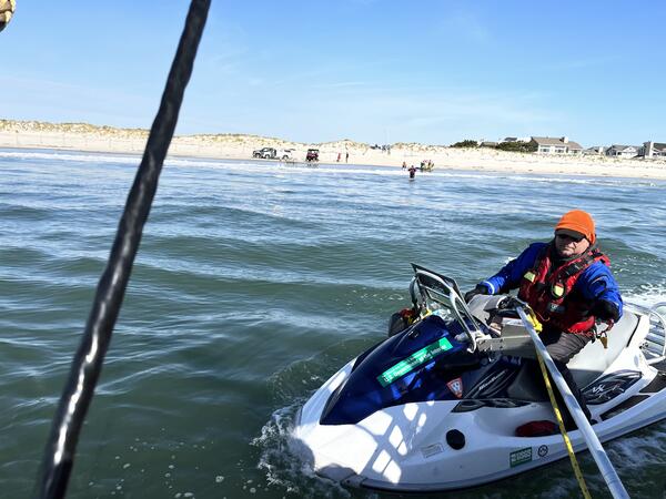
BJ Reynolds of the St. Petersburg Coastal and Marine Science Center operates a personal watercraft near the shoreline of Seven Mile Island, New Jersey. This vessel is used to collect single beam bathymetry (depth and seafloor shape) in the nearshore, and the equipment on the shoreline is used to collect chirp seismic reflection on the shoreface and inner shelf.
A scientist deploys a sound velocity cast from a boat while conducting a chirp geophysical survey offshore of the Rockaway Peninsula, New York. These geophysical data were used to quantify volumes of available shoreface sediment on this margin.
Implications for the resilience of modern coastal systems derived from mesoscale barrier dynamics at Fire Island, New York
Unlearning Racism in Geoscience (URGE): Summary of U.S. Geological Survey URGE pod deliverables
Exploring centennial barrier-inlet evolution: Insights from undeveloped and developed phases at Barnegat Inlet, New Jersey
This study aims to identify the natural processes and the subsequent responses to coastal engineering and development on the alongshore evolution of the IB-BI-LBI inlet-barrier system. The primary focus will be the quantification of barrier island and inlet sediment partitioning at decadal to centennial timescales, from 1839-1941. We analyze historical alongshore evolution and track coastal engine
Shoreface sediment availability offshore of a rapidly migrating, mixed-energy barrier island
Incorporating wave climate complexity into modeling lower shoreface morphology and transport
The lower shoreface, a transitional subaqueous region extending from the seaward limit of the surf zone to beyond the closure depth, serves as a sediment reservoir and pathway in sandy beach environments over annual to millennial time scales. Despite the important role this region plays in shoreline dynamics, the morphodynamics of the lower shoreface remain poorly quantified and understood. To bet
Contributions to uncertainty in runup forecasts
Reconstructing the geomorphic evolution and sediment budget history of a dynamic barrier island: Anclote Key, Florida
Decadal to centennial variations in sediment availability are a primary driver of coastal change within barrier systems. Models help explore how barrier morphology relates to past changes in magnitude of sediment availability, but this requires insights and validation from field efforts. In this study, we investigate the progradation of Anclote Key via its morphostratigraphy, a presently dynamic b
Contributions to uncertainty in runup forecasts
Reconstructing the geomorphic evolution and sediment budget history of a dynamic barrier island: Anclote Key, Florida
Undeveloped and developed phases in the centennial evolution of a barrier-marsh-lagoon system: The case of Long Beach Island, New Jersey
Barrier islands and their associated backbarrier environments protect mainland population centers and infrastructure from storm impacts, support biodiversity, and provide long-term carbon storage, among other ecosystem services. Despite their socio-economic and ecological importance, the response of coupled barrier-marsh-lagoon environments to sea-level rise is poorly understood. Undeveloped barri
Geologic framework, anthropogenic impacts, and hydrodynamics contribute to variable sediment availability and shoreface morphology at the Rockaway Peninsula, NY
Shoreface and Holocene sediment thickness offshore of Rockaway Peninsula, New York
Non-USGS Publications**
**Disclaimer: The views expressed in Non-USGS publications are those of the author and do not represent the views of the USGS, Department of the Interior, or the U.S. Government.
Python-based Subaerial Barrier Sediment Partitioning (pySBSP) model (ver. 1.0, February 2024)
Subaerial Barrier Sediment Partitioning (SBSP) Model Version 1.0
Science and Products
DUNEX Nearshore Geology
USGS DUNEX Operations on the Outer Banks
Storm-Related Barrier Island Morphological Evolution
Barrier Island Sensitivity to Changes in Sediment Supply
Shoreface Morphology and Geology
Modeling Barrier Island Evolution, Shoreface Morphology, and Overwash
Coastal Sediment Availability and Flux (CSAF) Capabilities
Coastal Sediment Availability and Flux (CSAF)
Coastal Change at Fire Island, a geonarrative
Coastal System Change at Fire Island, New York
Breach Evolution - Coastal System Change at Fire Island, New York
Hurricane Sandy - Coastal System Change at Fire Island, New York
Sediment Data from Vibracores Collected in 2021 From Central Florida Gulf Coast Barrier Islands
Chirp Sub-Bottom Profile Geophysical Data Collected in 2021 and 2022 From Duck, North Carolina
Chirp Sub-Bottom Profile Geophysical Data Collected in 2014 From Fire Island, New York
Chirp Sub-Bottom Profile Geophysical Data Collected in 2023 From the Chandeleur Islands, Louisiana
Coastal Multibeam Bathymetry and Backscatter Data Collected in May 2023 From Seven Mile Island, New Jersey
Coastal Bathymetry and Backscatter Data Collected in May 2023 From Rockaway Peninsula, New York
Ground Penetrating Radar and Global Positioning System Data collected in 2021 from Pinellas County Barrier Islands, Florida
Coastal Land-Cover and Feature Datasets Derived from Landsat Satellite Imagery, Delaware Bay, New Jersey to Shinnecock Bay, New York
Archive of Chirp Subbottom Profile Data Collected in 2022 From Seven Mile Island, New Jersey
As part of the Coastal Sediment Availability and Flux project, scientists from the U.S. Geological Survey (USGS) St. Petersburg Coastal and Marine Science Center (SPCMSC) conducted a nearshore geophysical survey to map the shoreface and inner shelf, as well as characterizing stratigraphy near Seven Mile Island, New Jersey (NJ) in April and May 2022. The objective of the project is to improve the u
Coastal Single-beam Bathymetry Data Collected in 2022 off Seven Mile Island, New Jersey
Sediment Data From Vibracores and Sand Augers Collected in 2021 and 2022 From Fire Island, New York
Ground Penetrating Radar and Global Positioning System Data Collected in 2021 From Fire Island, New York
A floating sled that enables sub‐bottom surveying in shallow water, nearshore, and shore‐face environments. The sled is equipped with an EdgeTech SB‐512i chirp system and single‐beam sonar. This equipment is used to collect seismic sub‐bottom profiles and single‐beam bathymetry.
BJ Reynolds of the St. Petersburg Coastal and Marine Science Center operates a personal watercraft near the shoreline of Seven Mile Island, New Jersey. This vessel is used to collect single beam bathymetry (depth and seafloor shape) in the nearshore, and the equipment on the shoreline is used to collect chirp seismic reflection on the shoreface and inner shelf.
A scientist deploys a sound velocity cast from a boat while conducting a chirp geophysical survey offshore of the Rockaway Peninsula, New York. These geophysical data were used to quantify volumes of available shoreface sediment on this margin.
Implications for the resilience of modern coastal systems derived from mesoscale barrier dynamics at Fire Island, New York
Unlearning Racism in Geoscience (URGE): Summary of U.S. Geological Survey URGE pod deliverables
Exploring centennial barrier-inlet evolution: Insights from undeveloped and developed phases at Barnegat Inlet, New Jersey
This study aims to identify the natural processes and the subsequent responses to coastal engineering and development on the alongshore evolution of the IB-BI-LBI inlet-barrier system. The primary focus will be the quantification of barrier island and inlet sediment partitioning at decadal to centennial timescales, from 1839-1941. We analyze historical alongshore evolution and track coastal engine
Shoreface sediment availability offshore of a rapidly migrating, mixed-energy barrier island
Incorporating wave climate complexity into modeling lower shoreface morphology and transport
The lower shoreface, a transitional subaqueous region extending from the seaward limit of the surf zone to beyond the closure depth, serves as a sediment reservoir and pathway in sandy beach environments over annual to millennial time scales. Despite the important role this region plays in shoreline dynamics, the morphodynamics of the lower shoreface remain poorly quantified and understood. To bet
Contributions to uncertainty in runup forecasts
Reconstructing the geomorphic evolution and sediment budget history of a dynamic barrier island: Anclote Key, Florida
Decadal to centennial variations in sediment availability are a primary driver of coastal change within barrier systems. Models help explore how barrier morphology relates to past changes in magnitude of sediment availability, but this requires insights and validation from field efforts. In this study, we investigate the progradation of Anclote Key via its morphostratigraphy, a presently dynamic b
Contributions to uncertainty in runup forecasts
Reconstructing the geomorphic evolution and sediment budget history of a dynamic barrier island: Anclote Key, Florida
Undeveloped and developed phases in the centennial evolution of a barrier-marsh-lagoon system: The case of Long Beach Island, New Jersey
Barrier islands and their associated backbarrier environments protect mainland population centers and infrastructure from storm impacts, support biodiversity, and provide long-term carbon storage, among other ecosystem services. Despite their socio-economic and ecological importance, the response of coupled barrier-marsh-lagoon environments to sea-level rise is poorly understood. Undeveloped barri
Geologic framework, anthropogenic impacts, and hydrodynamics contribute to variable sediment availability and shoreface morphology at the Rockaway Peninsula, NY
Shoreface and Holocene sediment thickness offshore of Rockaway Peninsula, New York
Non-USGS Publications**
**Disclaimer: The views expressed in Non-USGS publications are those of the author and do not represent the views of the USGS, Department of the Interior, or the U.S. Government.