RestoreNet ConMod with flowers in the Sonoran Desert
RestoreNet ConMod with flowers in the Sonoran DesertDiverse plants growing in a connectivity modified (ConMod) treatment in the Sonoran Desert. Photo by Molly McCormick.

Official websites use .gov
A .gov website belongs to an official government organization in the United States.
Secure .gov websites use HTTPS
A lock () or https:// means you’ve safely connected to the .gov website. Share sensitive information only on official, secure websites.
See our science through the images below.

Diverse plants growing in a connectivity modified (ConMod) treatment in the Sonoran Desert. Photo by Molly McCormick.
Diverse plants growing in a connectivity modified (ConMod) treatment in the Sonoran Desert. Photo by Molly McCormick.

USGS scientist Mike Tate sets up the mass spectrometer for mercury isotope measurements.
USGS scientist Mike Tate sets up the mass spectrometer for mercury isotope measurements.
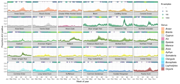
Percentage of individuals predicted to test positive for avian influenza virus (± 95% CI) for each species for each week ignoring spatial effects. Predictions are based on the overall prevalence values in the USDA dataset, which had a higher detection rate. Circles running along the x-axis indicate the number of samples for each species taken during that week.
Percentage of individuals predicted to test positive for avian influenza virus (± 95% CI) for each species for each week ignoring spatial effects. Predictions are based on the overall prevalence values in the USDA dataset, which had a higher detection rate. Circles running along the x-axis indicate the number of samples for each species taken during that week.

USGS scientist Andres Fritts holding a telemetered invasive bighead carp on the Mississippi River near Keokuk, Iowa.
USGS scientist Andres Fritts holding a telemetered invasive bighead carp on the Mississippi River near Keokuk, Iowa.

In 2022, we piloted RestoreNet V2.0 testing soil inoculation from undegraded reference sites, seed balls (white balls in photo), and pitting treatments (small indentions). Soil inoculation with healthy soils is expected to increase beneficial microbes at the degraded restoration site. Soil microbes can help reduce water stress in plants. Photo by Hannah Farrell.
In 2022, we piloted RestoreNet V2.0 testing soil inoculation from undegraded reference sites, seed balls (white balls in photo), and pitting treatments (small indentions). Soil inoculation with healthy soils is expected to increase beneficial microbes at the degraded restoration site. Soil microbes can help reduce water stress in plants. Photo by Hannah Farrell.

Invasion by annual brome grasses (cheatgrass and Japanese brome) on a trail across native prairie into National Park Service units in the Northern Great Plains.
Invasion by annual brome grasses (cheatgrass and Japanese brome) on a trail across native prairie into National Park Service units in the Northern Great Plains.

What can you do to conserve the birds and the bees, even in the face of climate change? In some cases, small actions, such as maintaining a pollinator garden or avoiding pesticides can be important. Take the rusty patched bumble bee, once one of the most common pollinators in eastern North America.
What can you do to conserve the birds and the bees, even in the face of climate change? In some cases, small actions, such as maintaining a pollinator garden or avoiding pesticides can be important. Take the rusty patched bumble bee, once one of the most common pollinators in eastern North America.

A group of controlled Culex mosquito eggs are viewed under a microscope in a California laboratory as part of an effort to mitigate avian malaria throughout the Hawaiian Islands. Image by Mia Takai
A group of controlled Culex mosquito eggs are viewed under a microscope in a California laboratory as part of an effort to mitigate avian malaria throughout the Hawaiian Islands. Image by Mia Takai
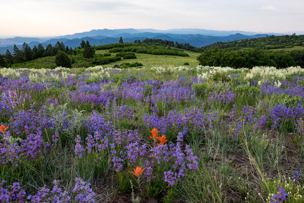
High Mesa Grassland Wilderness Study Area in Colorado with purple and orange wildflowers, Credit: Bob Wick, BLM.
High Mesa Grassland Wilderness Study Area in Colorado with purple and orange wildflowers, Credit: Bob Wick, BLM.
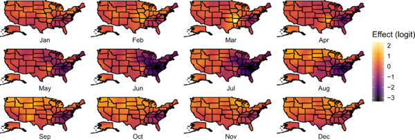
Monthly realizations of the spatial random field for the continental United States, with brighter colors indicating locations within a month with relatively greater avian influenza virus prevalence. Originally published in Kent et al.
Monthly realizations of the spatial random field for the continental United States, with brighter colors indicating locations within a month with relatively greater avian influenza virus prevalence. Originally published in Kent et al.
This research effort is an interagency partnership between U.S. Geological Survey and U.S. Fish and Wildlife Service to model the social-ecological system that encompasses chronic wasting disease management in the United States.
This research effort is an interagency partnership between U.S. Geological Survey and U.S. Fish and Wildlife Service to model the social-ecological system that encompasses chronic wasting disease management in the United States.

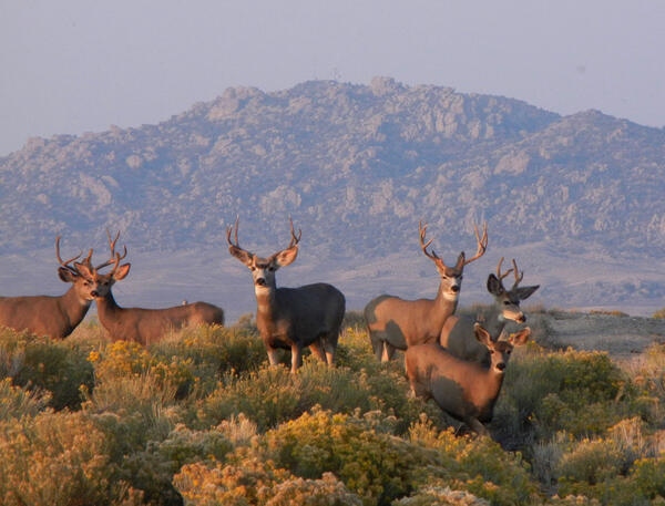
Nine-banded armadillos—the only armadillo species found in the United States—are distributed widely across southern states.
Nine-banded armadillos—the only armadillo species found in the United States—are distributed widely across southern states.

A polar bear walking along the Beaufort Sea coast with storm waves breaking behind it, filmed during fieldwork at Barter Island, Alaska.
A polar bear walking along the Beaufort Sea coast with storm waves breaking behind it, filmed during fieldwork at Barter Island, Alaska.

A map of black carp observations in the Mississippi River basin reported to the USGS Nonindigenous Aquatic Species database as of November 30, 2022. This map is not a complete representation of species abundance or distribution. These data include incidental captures by the public and reports from federal and state agencies.
A map of black carp observations in the Mississippi River basin reported to the USGS Nonindigenous Aquatic Species database as of November 30, 2022. This map is not a complete representation of species abundance or distribution. These data include incidental captures by the public and reports from federal and state agencies.

The words "5 Ways Climate Change Affects Caribou" are written in yellow with an icon of a brown caribou with large antlers in the bottom right corner.
Text reads:
"More wildfires lead to less lichen, as lichen can take decades to recover, and is an important food source for caribou in the winter."
The words "5 Ways Climate Change Affects Caribou" are written in yellow with an icon of a brown caribou with large antlers in the bottom right corner.
Text reads:
"More wildfires lead to less lichen, as lichen can take decades to recover, and is an important food source for caribou in the winter."

Distribution of Highly Pathogenic Avian Influenza H5 and H5N1 in North America, in Relation to U.S. Fish & Wildlife Service Refuges and National Park Service Lands, 2021/2022. Updated November 27, 2022.
Distribution of Highly Pathogenic Avian Influenza H5 and H5N1 in North America, in Relation to U.S. Fish & Wildlife Service Refuges and National Park Service Lands, 2021/2022. Updated November 27, 2022.

Distribution of Highly Pathogenic Avian Influenza H5 and H5N1 in North America, in Relation to Tribal Lands in the United States, 2021/2022. Updated November 27, 2022.
Distribution of Highly Pathogenic Avian Influenza H5 and H5N1 in North America, in Relation to Tribal Lands in the United States, 2021/2022. Updated November 27, 2022.

Five ways climate change affects manatees.
Graphic created by VSFS intern, Louise Johansson
Five ways climate change affects manatees.
Graphic created by VSFS intern, Louise Johansson

5 Ways Climate Change Affects Bats.
Graphic created by VSFS intern Louise Johansson.
5 Ways Climate Change Affects Bats.
Graphic created by VSFS intern Louise Johansson.

Scientist collected a stream sample during an urban stormwater runoff event in Seattle, WA
Scientist collected a stream sample during an urban stormwater runoff event in Seattle, WA

Researchers identified plants along a transect at a site invaded by cheatgrass at Kuna Butte near Caldwell, Idaho.
Researchers identified plants along a transect at a site invaded by cheatgrass at Kuna Butte near Caldwell, Idaho.