
This remote area along the southern Idaho-Oregon border was affected by the 2015 Soda Fire, which burned nearly 400 square miles of sagebrush habitat important to many species of wildlife, as well as federal and private ranchlands.
Images
See our science through the images below.
Filter Total Items: 3543

Crossing the Idaho-Oregon border in winter
This remote area along the southern Idaho-Oregon border was affected by the 2015 Soda Fire, which burned nearly 400 square miles of sagebrush habitat important to many species of wildlife, as well as federal and private ranchlands.
Wastewater from oil production in the Williston Basin leaked from a pipeline
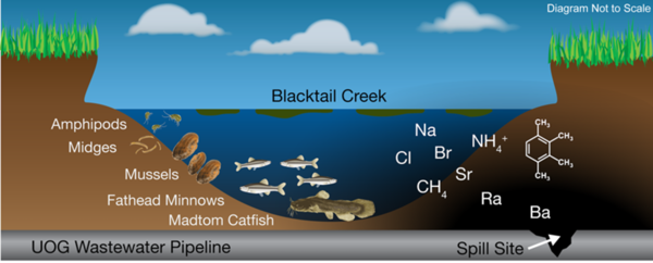
Wastewater from oil production in the Williston Basin leaked from a pipelineWastewater from oil production in the Williston Basin leaked from a pipeline, spilling into Blacktail Creek, North Dakota. Geochemical and biological samples were to identify geochemical signatures of spilled wastewaters as well as biological responses.
Wastewater from oil production in the Williston Basin leaked from a pipeline
Wastewater from oil production in the Williston Basin leaked from a pipelineWastewater from oil production in the Williston Basin leaked from a pipeline, spilling into Blacktail Creek, North Dakota. Geochemical and biological samples were to identify geochemical signatures of spilled wastewaters as well as biological responses.

A snowflake chain? Nope. A one-celled green alga.
The desmid family of single-celled green algae are never found in abundance, says USGS biologist Barry Rosen. They inhabit the soft, slightly acidic water of wetlands that depend on rainwater, like Florida’s Arthur R. Marshall Loxahatchee National Wildlife Refuge. They don’t “bloom” en masse, but their presence is an indicator of good water quality.
The desmid family of single-celled green algae are never found in abundance, says USGS biologist Barry Rosen. They inhabit the soft, slightly acidic water of wetlands that depend on rainwater, like Florida’s Arthur R. Marshall Loxahatchee National Wildlife Refuge. They don’t “bloom” en masse, but their presence is an indicator of good water quality.

Manatee Health Assessment
USGS conducts a health assessment on a mantee in Crystal River, Florida.
USGS conducts a health assessment on a mantee in Crystal River, Florida.

Manatee Health Assessment
USGS conducts a health assessment on a mantee in Crystal River, Florida.
USGS conducts a health assessment on a mantee in Crystal River, Florida.

Manatee Health Assessment
USGS conducts a health assessment on a mantee in Crystal River, Florida.
USGS conducts a health assessment on a mantee in Crystal River, Florida.

Manatee Health Assessment
USGS conducts a health assessment on a mantee in Crystal River, Florida.
USGS conducts a health assessment on a mantee in Crystal River, Florida.

Chinese Firebelly Newt
A Chinese firebelly newt (Cynops orientalis), the first salamander species found to be infected with the spring viraemia of carp virus.
A Chinese firebelly newt (Cynops orientalis), the first salamander species found to be infected with the spring viraemia of carp virus.

Largest American Alligator Satellite Telemetry-Tracking Study
Largest American Alligator Satellite Telemetry-Tracking StudySouth Carolina alligators occupy a patchwork of diverse habitats, including rivers, lakes, wooded swamps, tidal marshes, and impounded freshwater wetlands. As a mobile, opportunistic predator, alligators seasonally adjust their habitat use for feeding.

Collecting soil cores for a SageSTEP carbon budget study
Collecting soil cores for a SageSTEP carbon budget studyThis auger is used to collect 1 meter deep soil cores for a carbon budget study associated with the SageSTEP project. SageSTEP is a long-term, multi-disciplinary experiment evaluating sagebrush restoration methods in the Great Basin.

Turbid glacial runoff in Lake Clark National Park, Alaska
Turbid glacial runoff in Lake Clark National Park, AlaskaTurbid glacial runoff in roaring river, surrounded by mountains in Lake Clark National Park, Alaska.
Turbid glacial runoff in Lake Clark National Park, Alaska
Turbid glacial runoff in Lake Clark National Park, AlaskaTurbid glacial runoff in roaring river, surrounded by mountains in Lake Clark National Park, Alaska.

Eastern Tiger Salamander
Eastern tiger salamanders are on the move! This one was spotted crossing the road at St. Croix Wetland Management District in Wisconsin. Tiger salamanders mostly eat small insects and worms.
Photo by Caitlin Smith/USFWS.
Eastern tiger salamanders are on the move! This one was spotted crossing the road at St. Croix Wetland Management District in Wisconsin. Tiger salamanders mostly eat small insects and worms.
Photo by Caitlin Smith/USFWS.

Frosted flatwoods salamander
Frosted flatwoods salamander in St. Marks National Wildlife Refuge, Florida
Frosted flatwoods salamander in St. Marks National Wildlife Refuge, Florida

Native and invasive plants in desert southwest.
Native and invasive plants in desert southwest.
Native and invasive plants in desert southwest.

Water sampling on pontoon of a seaplane in Lake Clark National Park
Water sampling on pontoon of a seaplane in Lake Clark National ParkWater sampling on the pontoon of a seaplane in Lake Clark National Park, Alaska.
Water sampling on pontoon of a seaplane in Lake Clark National Park
Water sampling on pontoon of a seaplane in Lake Clark National ParkWater sampling on the pontoon of a seaplane in Lake Clark National Park, Alaska.

fishing off rock.jpg
Picture of boys fishing off rocks in the middle of a river with a beautiful background
Picture of boys fishing off rocks in the middle of a river with a beautiful background

Golden eagle fitted with Global Positioning System (GPS) backpack
Golden eagle fitted with Global Positioning System (GPS) backpackReports of golden eagle mortality linked to wind energy facilities are cause for concern especially when coupled with the knowledge that golden eagles move great distances between breeding and wintering areas. Mortalities at a particular wind energy facility can consequently affect breeding populations of golden eagles at local and continent-wide scales.

Testing for Bsal
Scientists sample a rough-skinned newt for the fungal pathogen Batrachochytrium salamandrivorans, or Bsal, at a pond near Portland, Oregon. Bsal is decimating wild salamander populations in Europe and could emerge in the U.S. thro
Scientists sample a rough-skinned newt for the fungal pathogen Batrachochytrium salamandrivorans, or Bsal, at a pond near Portland, Oregon. Bsal is decimating wild salamander populations in Europe and could emerge in the U.S. thro

Invasive black and white tegu lizards (Salvator merianae).
Invasive black and white tegu lizards (Salvator merianae).Invasive black and white tegu lizards (Salvator merianae). USGS is working on development of tools for the detection and capture of invasive reptiles in Florida.
Invasive black and white tegu lizards (Salvator merianae).
Invasive black and white tegu lizards (Salvator merianae).Invasive black and white tegu lizards (Salvator merianae). USGS is working on development of tools for the detection and capture of invasive reptiles in Florida.

Photomontage created to highlight the environment
Photomontage of multiple pictures showing environmental changes including within wildlife and urban environments
Photomontage of multiple pictures showing environmental changes including within wildlife and urban environments

Chinese Firebelly Newt
A Chinese firebelly newt (Cynops orientalis), the salamander species recently found to be infected with the spring viraemia of carp virus, or SVCV.
A Chinese firebelly newt (Cynops orientalis), the salamander species recently found to be infected with the spring viraemia of carp virus, or SVCV.